Exxaro Resources Limited
Consolidated Mineral Resources and Mineral Reserves report 2022
Grootegeluk is a large multi-seam, multi-product surface coal mining operation that has been operating since 1980. Grootegeluk has a long-term CSA with Eskom. The RoM is hauled to five tipping areas, which feeds six different beneficiation plants. The largest portion of the beneficiated product is power station coal, which is continuously dispatched to the Matimba and Medupi power stations via a conveyor belt system. Several sized metallurgical coal products, semi-soft coking coal and steam coal are railed to various customers and shipped internationally. A small portion of the total product is sold on site to smaller customers and dispatched by road.
Table 40: Grootegeluk overview
| Topic | Information | |
| Location | 25km west of the town of Lephalale in Limpopo, South Africa | |
| History |
Previous ownership |
Material notes |
| 1960s to 1980 |
Yskor - Iscor - Iscor mining - Kumba |
Exploration drilling |
| 1980 to present |
Kumba - Kumba coal - Exxaro Resources |
Mine commissioned in 1980. Mine in operation approximately 42 years. Continuous exploration drilling to increase Resource confidence as well as aid structural delineation and overburden classification. |
| Adjacent properties |
Thabametsi to the west |
|
| Infrastructure |
Grootegeluk can be reached from Lephalale via the hard-topped Nelson Mandela Drive, which is linked to the R510 road connecting Lephalale to the town of Vaalwater to the south and the Stockpoort border post between South Africa and Botswana to the north. Power supply to the mine is obtained directly from Matimba power station via two 132kV lines that supply the mine's three 840MVA transformers. Raw water is delivered to the mine and to a water treatment plant on the farm Zeeland by the 700mm diameter Hans Strijdom pipeline. The pipeline originates at the Mokolo Dam. Potable water from the Zeeland water-treatment plant is in turn routed to the mine and local communities. |
|
| Coalfield |
Grootegeluk is located in the Waterberg coalfield and the coal seams are from the Volksrust and Vryheid formations. |
|
| Main seams |
The upper part of the coal deposit, the Volksrust Formation (approximately 60m thick) is classified as a thick interbedded seam deposit type, comprising intercalated mudstone or carbonaceous shale and bright coal layers. The Vryheid Formation (approximately 55m thick) forms the lower part of the coal deposit and comprises carbonaceous shale and sandstone with interbedded dull coal seams varying in thickness from 1.5m to 9m. It is therefore classified as a multiple seam deposit type. |
|
| Seam development |
These coal seams are subdivided into 11 coal zones which are further divided into separate coal and non-coal samples for analysis. A total of 77 samples are analysed per full succession drill hole. The Volksrust Formation consists of 30 coal samples and 30 non-coal samples whereas the Vryheid Formation consists of 13 coal samples and four non-coal samples for the Vryheid Formation. |
|
| Depositional control |
The Zoetfontein fault forms the boundary of the Waterberg coalfield in the north while the Eenzaamheid fault forms the boundary in the south. The Daarby fault, with a throw of some 350m, divides the coalfield into a deep north-eastern portion and a shallow south-western portion. The first fresh coal in the shallow south-western portion is on average 20m below surface. The lowermost coal seam (Zone 1) occurs at a depth of about 130m in the shallow portion of the coalfield but this may vary depending on the local structure. The predominantly horizontal coal-bearing formations have a very gentle dip to the south-east near Grootegeluk. Only a few dolerite dykes outcrop in the south-eastern portion of the Waterberg coalfield and no sills have been encountered in any exploration drill holes drilled in the mine right area to date. |
|
| Resources and Reserves |
The Resource extent is restricted by the depositional controls discussed above. The Reserves are restricted within the Resource blocks. The reporting of LoM is limited to the lapse of the mining right although Coal Reserves exist well beyond this date. There is a small area of the Thabametsi mining right included in the Grootegeluk LoM (Figure 14) due to practical considerations. Both rights are owned by Exxaro. |
|
| Mining method |
Grootegeluk comprises one open-pit mine, which includes three overburden benches, 10 RoM benches and four interburden benches. A series of parallel benches are advanced progressively across the deposit via a process of drilling, blasting, loading and hauling with truck-and-shovel fleets. RoM is transported to the Grootegeluk beneficiation complex via haul trucks and in-pit crushing and conveying systems. |
|
| Beneficiation |
Grootegeluk makes use of six processing plants to beneficiate coal. This includes four dense medium separation beneficiation plants and two crushing and screening plants. |
|
| Product |
Various sized metallurgical coal products at 15% ash and 11.25% ash, semi-soft coking coal at 10.3% ash, as well as steam coal at 12.5% ash are railed to various customers and shipped to international customers via an export harbour. A small portion of the total product is sold on site to smaller customers and dispatched by road. |
|
| Market |
Local and export markets |
|
| Mining right |
Grootegeluk has an approved mining right that covers some 8 703.35ha. |
|
| Environmental approvals |
All environmental appeals have been favourably addressed for the declared Reserves. |
|
| Projects/feasibility studies |
The Grootegeluk Alternative Mining Solution (GGAMS) BFS project was aimed at reviewing various technology alternatives for the transportation of OVB material from Grootegeluk's mining pit to its In-Pit Discard Backfill system. To achieve this, the overburden was modelled in various material types with associated levels of confidence (Measured/Indicated/Inferred). The results indicated that the confidence levels of the OVB material types, OVB volumes and tonnages, top of coal and geological structures vary throughout the LoMP areas. For the areas of low confidence, proactive exploration drilling campaigns are required to ensure that increased levels of OVB confidence are available for accurate mine design and planning. The GG AMS study concluded that the base case trucking solution was still the most economical mining solution as opposed to an OVB impact crush and convey system. |
|
Figure 14: Grootegeluk mine
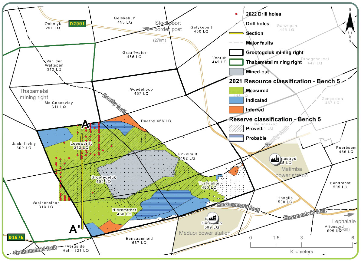
Figure 15: Grootegeluk cross-section
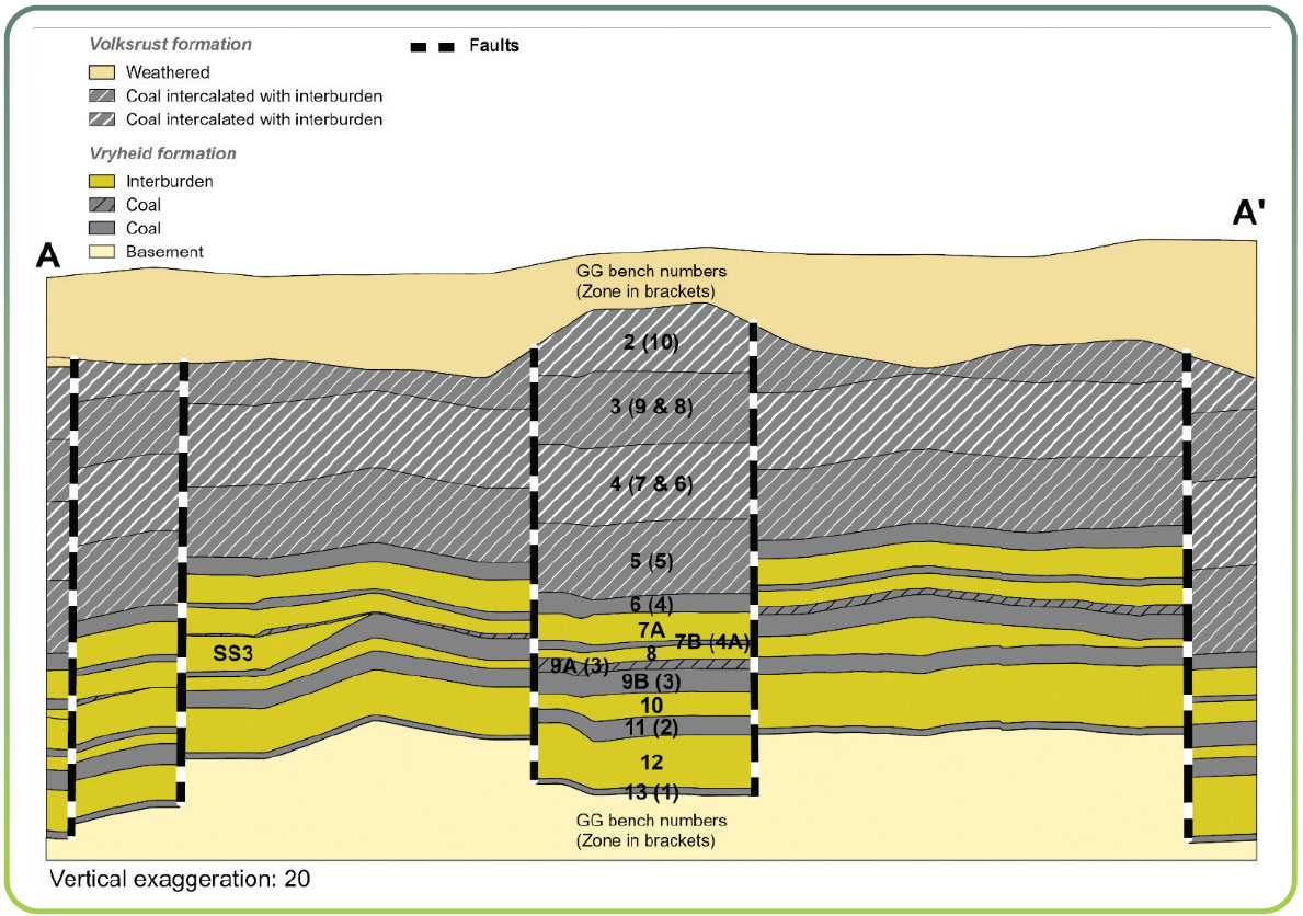
Table 41: Resource estimation methodology and reporting
| Process | Information |
| Drilling, logging and sampling |
In order to have sufficient material available from each sample for the required suite of analyses to relative densities of 2.20g/m3, large-diameter: 123mm diameter rotary core drill holes. The large diameter drill holes are drilled in between the existing 500m x 500m grid of small diameter drill holes. The reason for this placement of large diameter drill holes was that the analysis of samples from the large diameter drill holes could be used to supplement the analysis of existing small diameter drill holes where samples and density fractions were absent. Sampling of drill holes is only conducted after the stratigraphy has been correlated. The geologist in charge supervises all drill hole drilling and is responsible for logging and sampling. |
| Laboratory and accreditation |
Bureau Veritas, SANAS T0469. |
| Laboratory dispatch and receiving process |
Each sample submitted to the laboratory is accompanied by a unique sample number for validation and tracking, as well as a submission list that serves as a sample advice sheet with instructions for analysis. |
| Laboratory QAQC |
As part of the QAQC, audits are performed internally and externally. Bureau Veritas is accredited for analytical work and participates in monthly local and international round robins. |
| Data datum |
WGS84 - LO27 |
| Drill hole database |
acQuire |
| Number of drill holes in MR |
1 496 |
| Number of drill holes used for Resource estimation |
1 341 |
| Number of drill holes used for classification |
581 |
| Data compositing and weighting |
Data compositing is conducted per seam using a weighted value from individual samples that make up the seam, along with the relative density and length of each individual sample. This is conducted in acQuire. |
| Data validation |
Conducted using queries in acQuire, MinexTM and Excel |
| Geological modelling software |
GEOVIA MinexTM |
| Estimation technique |
Growth algorithm |
| Previous model date |
2020 |
| Last model update |
2022 |
| Grid mesh size |
20m x 20m |
| Scan distance |
1 000m |
| Data boundary |
100m |
| Model build limits |
Upper: limit of weathering and topography/collar |
| Model outputs |
Roof, floor and thickness grids generated for structure Raw and wash quality grids |
| Changes to modelling process |
None |
| Thickness cut-off and extraction height considerations |
Opencast ≤0.5m |
| Quality cut-offs (adb) |
≥65% ash Volksrust Formation coal, ≥50% ash Vryheid Formation coal |
| Geological loss applied |
Variable per bench, calculated each year considering geological model estimation error and physical geological loss. |
Table 42: Resource classification criteria
| Category | Type of drill holes | Drill hole spacing | Structurally complex areas | Drill holes/ha |
| Measured |
Cored drill holes with applicable coal qualities |
0m to 500m |
(Matrix) Additional geophysically logged drill holes needed |
0.10 |
| Indicated |
Cored drill holes with applicable coal qualities |
500m to 1 000m |
(Matrix) Additional geophysically logged drill holes needed |
0.05 |
| Inferred |
Cored drill holes with applicable coal qualities |
1 000m to 3 000m |
(Matrix) Additional geophysically logged drill holes needed |
0.02 |
Table 43: RPEEE considerations
| Item | Criteria | Criteria met | Comment |
| Geological data |
Data has been validated and signed off by Competent Person |
Yes |
Geological structures, seam thickness ≤0.5m, ash content ≥65% ash Volksrust Formation coal and ≥50% Ash Vryheid Formation coal. Coal qualities reported on an adb. |
| Geological model |
Geological model has been considered and signed off |
Yes |
2022 |
| Structural model |
Structural model was considered and signed |
Yes |
2022 |
| Mining |
Mining assumptions were considered and defined |
Yes |
Opencast |
| Assurance |
Exxaro internal audits and external audit were conducted |
Yes |
Internal review on Resource processes and LoM in 2022. |
| Economic evaluation |
Conducted an exploitation study with economic and mining assumptions, including geotechnical and geohydrological assumptions |
Yes |
Exploitation strategy over mining right. |
| Environmental |
Reasonable demonstration that environmental approvals can be obtained within the context of local, regional and national governmental legislation |
Yes |
All applicable approvals are in place. |
| Tenure |
Formal tenure must be demonstrated with reasonable demonstration that a mining right approval can be obtained within the context of local, regional and national governmental legislation |
Yes |
Mining right with no impediments is valid until 2041 and there is a reasonable expectation that the right will be renewed. |
| Infrastructure |
Assumptions used should be reasonable and within known/assumed tolerances or have examples of precedence |
Yes |
Existing infrastructure adequate and can be upgraded with new required infrastructure under construction. |
| Market |
A potential market for the product with a reasonable assumption that this market is sustainable |
Yes |
Current CSAs for local and export markets. |
Table 44: Reserve estimation
| Topic | Information |
| Software | OCCS |
| Reserving process | Production scenarios are defined by scrutinising different market demand scenarios for product sales, as well as evaluating estimated future installed production capacity. Ultimately, care is taken to select the most probable scenario to be scheduled as the LoMP. Once the RoM and product schedule are completed, a process is followed whereby the OVB and interburden scheduling is altered, to obtain a "smoothed" year-on-year ex-pit profile, to prevent erratic mining equipment requirements. The pit shell is designed from an economic and product quality perspective to ensure the longevity of the Grootegeluk operation. |
| Conversion classification | Indicated Resources are generally converted to Probable Reserves and Measured Resources to Proved Reserves after consideration of all applicable modifying factors. If one or more of the modifying factors have not been fulfilled, Measured Resources are either not converted or the Measured Resources are converted but downgraded to Probable and the associated risk is clearly stated. Inferred Resources are not converted to Coal Reserves. |
| Inferred Resources inside LoM | Some 73Mt of Inferred Resources are included in the LoM plan, representing 2.8% of the LoM plan, and are not considered material. The impact of the Inferred Resources is known with the majority thereof occurring at the tail end of the LoMP and addressed by an integrated exploration plan that is reviewed every year. |
| Modifying factors | |
| Average thickness cut-off | ≤0.5m |
| Quality cut-offs | ≥65% ash content (raw in situ) |
| Mining loss | No loss applied as all mining boundaries are reached, and no pillars are left |
| Boundary pillar | N/A |
| Dilution | No dilution is planned |
| Contamination | No contamination factor is applied |
| Mining recovery efficiency | Varies per bench 0 to 0.75m depending on bench height |
| Planned average slope angles | <61.7 degrees |
| Practical plant yield | Considered in the reserving process as per wash table information per combination of blocks per planning increment and the empirically determined practical yield adjustment factor. |
| Strip ratio cut-off | Energy strip ratio >7GJ/ex-pit tonne |
| Environmentally sensitive areas | Areas underlying wetlands and other eco-sensitive areas are excluded from the Reserves, distance as per environmental requirements. |
| Legal | The layout is within the mining right boundary and not closer than 15m. |
| Social | There are no known socially sensitive areas in the pit layout (for example, graveyards and dwellings). |
| Geohydrological | Areas identified are flagged and excluded or reclassified in the reserving process. |
Table 45: Grootegeluk Coal Resources and Coal Reserves statement
| Category | 2022 (Mt) |
2021 (Mt) |
Difference in tonnes (Mt) |
Difference (%) |
Reason for change |
| Measured | 3 039 | 2 481 | 558 | 22 | The decrease is the result of mining (~59Mt) and the removal of a portion of bench 7B due to high ash content (~4Mt), which was offset by new information (621Mt). |
| Indicated | 967 | 1 421 | (455) | (32) | The decrease is the result of the removal of bench 7B to waste (4Mt) and new information (451Mt). |
| Inferred | 178 | 338 | (160) | (47) | The decrease is due to new information (160Mt). |
| Total Coal Resources | 4 184 | 4 240 | (56) | (1) | |
| Proved | 2 034 | 1 682 | 352 | 21 | The overall increase due to mining (58Mt) and the removal of bench 7B (28Mt) was offset by reconciliation (1Mt) and the change in Resource base (437Mt). |
| Probable | 550 | 898 | (348) | (39) | The decrease is the result of the removal of bench 7B (11Mt) and new information (337Mt). |
| Total Coal Reserves | 2 584 | 2 580 | 4 | 0 |
| Rounding of figures may cause computational discrepancies. |
| Tonnages quoted in metric tonnes and million tonnes (Mt). Coal Resources quoted as MTIS. |
Table 46 outlines the exploration for the reporting year. For detailed expenditure, please refer to Table 64.
Table 46: Exploration summary
| Objective | Progress in reporting year | Plans for the next reporting year |
|
Geological and geotechnical overburden material characterisation, delineation of structures and resource classification |
Seventy six (76) percussion holes drilled for OVB material classification and to aide in the delineation of faults in structurally complex areas Four (4) shallow rotary core drill holes drilled for geotechnical characterisation of the OVB. Ten (10) deep rotary core drill holes drilled to obtain samples for quality analysis and to aide in Resource classification |
Ten (10) rotary core drill holes for Resource estimation and classification. Two (2) rotary core drill holes for geometallurgical studies. Three (3) deep rotary core drill holes for geotechnical characterisation. Thirty (30) percussion drill holes for OVB classification and structural delineation. Three (3) percussion drill holes for water monitoring. |
Table 47: Grootegeluk risks
| Risk | Description | Mitigation |
| Unweathered OVB availability |
Material in the west is more weathered with less shale material available |
Borrow pit in the north to be constructed to source non-weathered material for backfill construction (included in the updated LoMP). |
| Management of excessive rainwater in the pit |
Risk of flooding pit floor if rainfall is above mean annual rainfall; impact on B11 mining |
Sump strategy and diversion of water from plant (included in updated LoMP). |
| GDIP phase 3 timelines |
The plant waste is stacked using two progressing vertical levels known as the upper system and the lower system. These systems are approximately 860m and 900m above sea level respectively (860m-level and 900m-level). The 860 plant waste system is reaching the turn and the mine is at risk of having only one waste system running |
Prolong utilisation of 860 plant waste area. |
| Delayed arrival of additional truck capacity |
Mining capacity shortage in H1 2023 |
Mining contractor appointed to start mining sumps, alleviating some of the constraints on the fleet. |
| Full product stockpiles |
TFR offtake challenges |
Reviewing options to address the shortcomings in the TFR offtake as well as considering alternatives to optimise the transport to our various customers. |
Strategic backfill is crucial to the effective execution of Grootegeluk. New information distinguishing between the various OVB material types contributed to the mine integrating backfill and mining activities into a consolidated plan that enables detailed material destination scheduling. The plan provisions for a sump strategy for effective in-pit water management, which addresses a historical operational challenge in the large open pit. In addition, the plan includes consolidating and redefining certain waste mining benches based on economical and practical considerations and improving mining activity sequencing to ensure the continuous supply of suitable material to all specified destinations. The conclusion of the plan is an exceptional achievement for Exxaro.