Exxaro Resource limited Report Selector 2018


Currently viewing Mineral Resources Report 2018
Currently viewing Mineral Resources Report 2018

Exxaro Resources Limited Mineral Resources Report
Operation overview
Figure 13: Belfast mine |
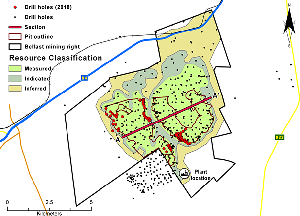 |
The Belfast mine is located some 10km south-west of the town of Belfast in Mpumalanga, South Africa, on the far eastern edge of the Witbank coalfield. The coalfield extends about 190km east-west between the towns of Springs
and Belfast, and about 60km in a north-south direction between the towns of Middelburg and Ermelo. The mineral tenure areas of Umsimbithi Mining and Universal Coal (Paardeplaats) are
to the north of Belfast, with the Umsimbithi Mining, Wonderfontein coal mine to the far west.
The Belfast mine is adjacent to the N4 highway connecting Pretoria and Maputo and
can be accessed from the N4 via two district roads, namely D1110 and D1770. The mine
is also adjacent to the railway line to Maputo. There are nearby loading facilities that link to the railway line to Richards Bay. Once fully developed, the mine will have seven opencast pits. There are prospects for additional opencast pits and an underground mining section.
Thermal coal will be beneficiated in a two-stage dense medium separation plant (currently under construction that will handle ROM at 500t/hr) to produce a primary product of 6 000kcal/kg net as received (NAR) and a secondary product of 21.6Mj/kg. Both products are suitable for the export market, but the secondary product can also
be sold in the domestic market. Mobile crush-and-screen plants may be brought on site as needed. There are existing Eskom power lines on the property for electricity supply.
The mining right has been approved and all environmental appeals have been favourably addressed. Mining operations will start in Q1, 2019.
Operation history
Belfast Coal has an approved mining right that covers 7 198 hectares. The geological model incorporates 387 drillholes.
Table 18: Belfast operation history
| Date range | Company | Material notes | ||||||
| 1967 | Fuel Research Institute of South Africa (FRI) | 25 drillholes | ||||||
| 1969 | Trans-Natal Steenkoolkorporasie Beperk (TNS) | 10 drillholes | ||||||
| 1975 — 1983 | Gold Fields Mining and Development (GFM&D) | 43 drillholes | ||||||
| 2001 — 2003 | Eyesizwe | 155 drillholes | ||||||
| 2008 — 2009 | Exxaro | 153 drillholes, to refine classification and potential box-cut positions |
Operation geology
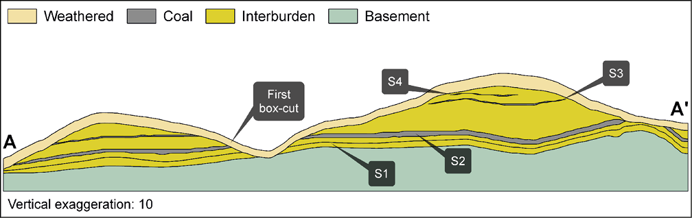
The Witbank coalfield, which has up to five coal seams contained in the middle Ecca group sediments of the Karoo supergroup. The Karoo sequence in the area is represented by the Dwyka formation and the middle Ecca, with little or no lower Ecca development. The middle Ecca sequence of coal horizons interbedded with sediments is highly truncated due to erosion, with only very minor areas where the full sequence is developed. The no 2 seam dips gently to the south. Locally, there are mainly three seams, seams 2, 3 and 4. Seam 5 was intersected in only two drillholes in the northern part of the project area. The target seams, with seam 2 being most prevalent, make up 86% of the Coal Resource. The seam is consistently developed, except in areas where it has been eroded, and has an average thickness of 2.8m. Seam 3 is also sporadically developed due to erosion and has an average thickness of 0.6m at an average depth of 60m. Due to the proximity of the northern edge of the Witbank Basin, the primary control of the coal development is the current weathering surface. The deposit is therefore divided by a perennial stream into two resource blocks under two distinct spurs in the surface topography. There is no indication of pertinent faulting from the borehole information, but potential intrusions of dolerite dykes are outlined by regional airborne magnetics, indicating the possible occurrence of regional north-south trending dykes.
There are no known geological structures that may affect the geology or coal seam continuity.
Figure 14: Belfast west-east cross section
Operation resource evaluation
The geologist in charge supervises all borehole drilling and is responsible for logging and sampling, aligned and in compliance to logging and sampling standards and standard operating procedures (SOPs). Sampling of boreholes is only conducted after the stratigraphy has been correlated. All samples collected and bagged are registered in a sample sheet which is also used as a dispatch sheet. The dispatch sheet is signed by the receiving laboratory personnel after ensuring that the number and sample ID on the dispatch sheet matches that of the actual samples to be analysed. The analysis required is clearly explained in the sample dispatch sheet. The turnaround time is calculated as the time from which the laboratory receives the samples to the time when the last batch of analysis is reported. Once the laboratory receives and signed the dispatch sheet, the safekeeping and storage of that batch of samples lies with the laboratory.
All coal analysis was conducted at Bureau Veritas and is ISO/IEC 17025:2005 accredited. Due to the nature of coal, quality assurance and control procedures are limited as matrix-matched blanks and coal material standards are not commonly available or used. Great emphasis is, however, placed on ensuring data integrity though rigorous procedures and supervision during processing. As part of the assurance and control process, audits are performed internally and externally. Internal audits are periodically done by the laboratory accreditation department using SANAS F48 and F49, which cover management and technical requirements as per ISO 17025. Customer audits are performed by clients to ensure they receive quality service.
No changes in the Coal Resources or Coal Reserves are reported.
Table 19: Belfast Coal Resource reporting criteria
| Thickness cut-off (thickness and extraction height considerations) | Quality cut-offs (adb) | Geological loss | ||||||
| <1.0m | Ash >50% | 5% |
Table 20: Belfast Coal Resource estimation criteria
| Item | Description | ||||||||
| Database | Drillhole database | acQuire | |||||||
| Data datum | Cape LO29 | ||||||||
| No drillholes used for resource estimation | 387 | ||||||||
| Validation | Conducted using queries in acQuire Excel | ||||||||
| Data compositing and weighting | Minex | ||||||||
| Model | Previous model date | 2012 | |||||||
| Last model update | 2009 | ||||||||
| Geological modelling software | Geovia Minex | ||||||||
| Estimation technique | Growth algorithm | ||||||||
| Grid mesh size | 25m x 25m | ||||||||
| Scan distance | 2 000m | ||||||||
| Data boundary | 200m | ||||||||
| Model build limits | Upper: limit of weathering and topography/collar Lower: basement/Dwyka | ||||||||
| Model outputs | Roof, floor and thickness grids generated for structure. Raw quality grids | ||||||||
| Changes to modelling process | None |
Table 21: Belfast Coal Resource classification criteria
| Category | Type of boreholes | Borehole spacing | Structurally complex areas | BH/ha | |||||||||||||
| Measured | Cored boreholes with applicable coal qualities | 0 – 350m | RODA | 0.08 | |||||||||||||
| Indicated | Cored boreholes with applicable coal qualities | 350 – 500m | RODA | 0.04 | |||||||||||||
| Inferred | Cored boreholes with applicable coal qualities | 500 – 1 000m | RODA | 0.01 |
Table 22: Belfast Resource and Reserve statement
| Category | 2018 (Mt) (OC) |
2017 (Mt) (OC) |
Difference (%) |
||
| Measured | 81.1 | 81.1 | – | ||
| Indicated | 22.4 | 22.4 | – | ||
| Inferred | 34.4 | 34.4 | – | ||
| Total Resources | 137.8 | 137.8 | – | ||
| Proved | 45.7 | 45.7 | – | ||
| Probable | – | ||||
| Total Reserves | 45.7 | 45.7 | – |
| Rounding of figures may cause computational discrepancies |
| All changes more than 10% are explained |
| Mining method: OC — opencast |
| Figures are reported at 100% irrespective of percentage attributable to Exxaro |
| The tonnages are quoted in metric tonnes and million tonnes is abbreviated as Mt. Coal Resources are quoted as minable tonnes in-situ and refer to remaining resources after 31 December 2018 and 31 December 2017 |
| Coal Resources are reported on a mineable in-situ (MTIS) basis |
| Coal Resources are quoted inclusive of Coal Reserves |
Table 23: Belfast RPEEE considerations
| Item | Criteria | Criteria met (Y/N) |
Comment | ||||||||||
| Geological data | Data has been validated and signed-off by competent person | Yes | Geological structures and depositional extent, seam thickness <1.0m (OC), >50% ash content. Coal qualities reported on an air-dry basis | ||||||||||
| Geological model | Geological model has been considered and signed off | Yes | |||||||||||
| Structural model | Structural model was considered and signed off | Yes | 2017 | ||||||||||
| Mining | Mining assumptions considered and defined | Yes | Opencast | ||||||||||
| Assurance | Exxaro internal audits and external audit conducted | Yes | External audit conducted in 2015 | ||||||||||
| Economic Evaluation | Exploitation study with economic and mining assumptions, including geotechnical and geohydrological assumptions | Yes | Belfast exploitation strategy over mining right | ||||||||||
| Environmental | Reasonable demonstration that environmental approvals can be obtained within the context of local, regional and national governmental legislation | Yes | EMP, IWUL and NEMA licences in place and compliant | ||||||||||
| Tenure | Formal tenure must be demonstrated. Reasonable demonstration that a mining right approval can be obtained within the context of local, regional and national governmental legislation | Yes | Mining right in place Land acquisitions will be done with expansions |
||||||||||
| Infrastructure | Assumptions used should be reasonable and within known/assumed tolerances or have examples of precedence | Yes | Existing infrastructure adequate or can be upgraded. New required infrastructure under construction | ||||||||||
| Market | A potential market for the product with a reasonable assumption that this market is sustainable | Yes | Primary product qualities suitable for A-grade export market and middlings suitable for domestic power generation |
Operation reserve estimation
Scheduling of the reserve is determined using mining scheduling applications from XPAC. This is the same software used to develop the LoMP schedule. The geological 3D model used for the resource statement is referred to as the reserve geological 3D model. This reserve model differs from the resource model. The resource model uses the full coal seam while the reserve model uses a select mining height from the drillhole profile.
The geological model has been created by Exxaro geosciences, using Minex software, and this is then supplied to mining processes in the form of Minex grids. The grids and DXF files were converted by mining processes to Surpac files. The methodology used by mining processes is to initially validate the geological information received, check the integrity of the structure, and that quality and wash-table values are consistent.
Indicated Resources are generally converted to Probable Reserves and Measured Resources to Proved Reserves except if one of the modifying factors have not been fulfilled, where the Measured Resource is either not converted or the Measured Resource is converted but downgraded to Probable and the risk is clearly stated. Inferred Resources are not converted to Coal Reserves.
Some 0.5Mt of Inferred Resources are included in the life-of-mine plan and are not considered material. The area with Inferred Resources, on the western edge of the pit will only be reached towards the end of life-of-mine. This is a new mine, yet to be exploited, and there are thus no production figures.
Table 24: Belfast modifying factors in the conversion of Coal Resources to Coal Reserves
| Modifying factors | Value | ||||
| Geological loss | 5% | ||||
| Average thickness cut-off | 1.0m | ||||
| Quality cut-offs | No quality cut-offs, economic cut-offs | ||||
| Mining loss | 5% | ||||
| Boundary pillar | – | ||||
| Dilution | 0% | ||||
| Contamination | 0.1m (8.94%) | ||||
| Mining recovery efficiency | 100% (already accounted in mining loss) | ||||
| Planned average slope angles | – | ||||
| Practical plant yield | 88.11% | ||||
| Strip ratio cut-off | – | ||||
| Environmentally sensitive areas | Environmentally sensitive areas excluded, or applications made | ||||
| Legal | Applicable mining right considered | ||||
| Social | Applicable communities considered | ||||
| Geohydrological | Applicable surface and groundwater models considered |

Known risks
Modifying factors are currently theoretical and will be reviewed after actual mining has started and reconciliation data is available. Risk of weathered material in the proposed box-cuts has been investigated through drilling and box-cut outlines adjusted. We do not know of any pertinent risks or other material conditions that may impact on the company's ability to mine or explore, including technical, environmental, social, economic, political and other key risks.
Operational excellence
Early cash-generating mining activities have started, which will see mining operations begin in 2019. Further expansion for both opencast and underground potential towards the north of the current LoMP area is under investigation.