Exxaro Resource limited Report Selector 2018


Currently viewing Mineral Resources Report 2018
Currently viewing Mineral Resources Report 2018

Exxaro Resources Limited Mineral Resources Report
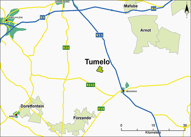
| Figure 29: Tumelo locality map |
|
Project overview
Tumelo Coal Mine forms part of Exxaro Coal Central (ECC), and is in Mpumalanga, 15km north-west of the town of Hendrina and 5km south-east of Hendrina power station. The Hendrina-Middelburg tarred road passes 6km east of the property. An all-weather dirt road linking the town of Hendrina and the power station runs 500m to the west of the property, while the Wonderfontein-Broodsnyersplaas railway line lies 2km west, with the closest siding being Pullenshope, 3.5km away.
Tumelo's mining right (116 MR) covers 462.9ha on the farm Boschmanskop 154 IS. Following the purchase of Total Coal South Africa (TCSA) assets by Exxaro in August 2015, the current Tumelo shareholding is 51% Mmakau Mining and 49% ECC.
Surface infrastructure still in use includes: mine buildings (offices, workshops and change houses), box-cuts to access the coal seam, conveyor belt systems and a ROM stockpile facility. After operating for six years, Tumelo ceased production in January 2014 after its mining contract expired, and it was placed on care and maintenance.
Since then, a series of technical and economic evaluations were conducted by both TCSA and Mmakau Mining, reviewing the potential of the remaining mineable reserves, mining method and production rate. Mmakau Mining is currently reviewing the option to recommission the operation in Q2 2019.
Tumelo exploits seam 2 on the edge of the Springs-Witbank coalfield and RoM was trucked using existing roadways to Forzando North (FZON) where it was beneficiated for a 5 800kcal/kg export product.
Project history
Exploration activities started in the early 1990s, with a mining right submitted in 2006 and first coal production in 2009. To date, there are 132 boreholes (103 with coal wash data) in Tumelo's mining right area. The 2017 geological model update incorporated all existing boreholes with wash quality information. In general, Tumelo has a borehole distribution of 0.22bh/ha.
Table 72: Tumelo project history
| Date range | Company | Material notes | |||||||
| 1990 | Senekal Mine | The first company to conduct exploration programme, drilling 26 boreholes | |||||||
| 1991 | Hanover Mining | Further exploration work, 34 boreholes drilled | |||||||
| 2002 | Total Exploration South Africa (TESA) | TESA acquired the project, with 18 boreholes drilled during its tenure. A feasibility study in 2002 confirmed the presence of economic Coal Reserves. The Boschmanskop project would later become known as Tumelo | |||||||
| 2004 - 2013 | Total Coal South Africa (TCSA) | Further exploration work undertaken by TCSA. Mining right applied for in 2006 in the name of Tumelo Coal Mine. First coal recorded in 2009, exploiting S2 via bord-and-pillar method. Mining outsourced to SBS Mining Proprietary Limited, a mining contractor. Initially ROM coal was custom washed for an export product at the Shanduka (Glencore)-owned Koornfontein Colliery washing plant but would later be trucked to TCSA's FZON and washed for a 5 800kcal/kg export product | |||||||
| 2014 - 2015 | Total Coal South Africa (TCSA) | Production ceased in January 2014 when the mining contract expired. Failure to agree on a possible extension with the contractor led to the operation being placed under care and maintenance in February 2014 | |||||||
| 2015 - 2018 | Exxaro Coal Central (ECC) | TCSA became ECC after being taken over by Exxaro in August 2015. Tumelo remained under care and maintenance |
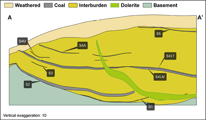
| Figure 30: Tumelo cross section |
|
Project geology
Tumelo is to the north of the Smithfield Ridge on the north-eastern edge of the Springs-Witbank coalfield. The area is part of the Karoo basin whose stratigraphy is similar to that of other ECC operations, Dorstfontein and Forzando, with subtle location-induced differences.
Six coal seams are developed in the area, named from the base up as S1, S2, S4L, S4U, S4A and S5. S1 is very thin, being only developed in the deepest part of the palaeo-valley. The thickest average seam is the S2 (0.5m to 5.3m), developed mainly in a palaeo-valley where it is either thin or absent over the adjacent palaeo-ridges. Seam 2 has been exploited since Tumelo production started in 2009. S4L is the most continuous and second-thickest seam while S4U is thin and has mostly been eroded. S4A is thin and patchily developed, and S5 is only present in a topographically high area in the south east. The only economically exploitable seam is S2.
Late Jurassic dolerite sills and dykes occur in the Tumelo area. The intrusions resulted in displacement of the various seams and devolatilisation of extensive areas of coal. The geological complexity and associated challenges are proactively managed by extensive infill drilling, downhole wireline logging for better contact definition and seam correlation as well as surface mapping, particularly of basement outcrops. This information is captured in a structural model, together with potential captured in a GIS based risk and opportunity domain analysis (RODA), allowing for a more integrated approach to risk management.
Project resource evaluation
All exploration boreholes are logged and sampled by qualified geologists, aligned with Exxaro logging and sampling standards and COPs. Samples are selected according to seam boundaries, visual variation in the vitrinite content, assisted by density logs, and non-coal material present in the seam boundaries. The geologist takes cognisance of the borehole purpose and drilling conforms to ECC standards.
ECC's sampling governance and chain of custody requires that each sample to be submitted to the laboratories is accompanied by a sample submission list that also serves as a sample advice sheet with instructions for analysis. The laboratory is notified of samples that are ready for collection. On collection, the laboratory representative cross-checks all samples against the submission list to confirm the names and number of samples they are receiving. All submission lists are managed in duplicates with signed copies scanned and saved electronically in the geology server.
All geological core sample are sent to the laboratory for coal quality analysis. Two major laboratories have been used at Tumelo: Australian Laboratory Services (ALS) and Societe Generale de Surveillance (SGS) with SANAS accreditation (T0611 and T0815, respectively). ISO and South African National Standards (SANS) have a standard set of tests and methods used for coal analysis by South African laboratories. These laboratories have committed to assuring the quality of results provided to the customer by ensuring quality assurance, quality control, data validation and proficiency testing procedures are observed.
Table 73: Tumelo Coal Resource reporting criteria
| Thickness cut-off (reporting and extraction considerations) | Quality cut-offs (adb) | Geological loss* | ||||||
| Underground <1.2M | DAFV <26% Raw ash >50% |
10 - 50% |
*A 10% standard geological loss is applied but may vary based on consideration of structural complexity (dolerite sill) breakthrough - 50% loss within determined spatial extent), seam gradient (>4 degrees - 50% loss), dolerite sill proximity to seam (25% loss). A 15% geological loss is applied (weighted average of the various risk domains).
Table 74: Tumelo Coal Resource estimation criteria
| Item | Description | ||||||||
| Database | Drillhole database | Sable Data Warehouse | |||||||
| Data datum | Cape LO29 | ||||||||
| Number of drillholes used for resource estimation | 103 of 132 boreholes in the database with washability data | ||||||||
| Validation | The laboratory conducts data validation and proficiency testing on samples submitted. In the Sable Database Warehouse, additional validations are conducted on points of observation where missing data and/or duplicate data are identified and corrected. Data is exported from Sable into csv files where it is subjected to 'coal sense' checks | ||||||||
| Data compositing and weighting | Data compositing is conducted per seam using a weighted value from individual samples that make up the seam, along with the RD and length of each sample. This is done in Geovia Minex | ||||||||
| Model | Previous model date | January 2010 in Stratmodel | |||||||
| Last model update | January 2017 | ||||||||
| Geological modelling software | Geovia Minex 6.3.2 | ||||||||
| Estimation technique | Growth algorithm - general purpose gridding | ||||||||
| Grid mesh size | 25m x 25m | ||||||||
| Scan distance | 2 000m | ||||||||
| Data boundary | 200m | ||||||||
| Model build limits | Upper: limit of weathering and topography/collarLower: basement/Dwyka | ||||||||
| Model outputs | Roof, floor and thickness grids generated for structure.Raw quality and washability grids | ||||||||
| Changes to modelling process | Change in modelling package from Stratmodel to Geovia Minex |
Table 75: Tumelo Coal Resource classification criteria
| Category | Type of boreholes | Borehole spacing | Structurally complex areas | BH/ha | |||||||||||||
| Measured | Cored boreholes with applicable coal qualities | 0 - 350m | Structural complexity and coal variability - additional infill drilling | 0.30 | |||||||||||||
| Indicated | Cored boreholes with applicable coal qualities | 350 - 500m | Structural complexity and coal variability - additional infill drilling | 0.20 | |||||||||||||
| Inferred | Cored boreholes with applicable coal qualities | 500 - 1000m | Structural complexity and coal variability - additional infill drilling | 0.11 |
Table 76: Tumelo Resource and Reserve statement
| Category | 2018 (Mt) | 2017 (Mt) | Difference (%) | |
| Measured | 8.7 | 8.7 | 0 | |
| Indicated | 0.2 | 0.2 | 0 | |
| Inferred | 1.8 | 1.8 | 0 | |
| Total Resources | 10.7 | 10.7 | 0 | |
| Proved | 0.7 | 0.7 | 0 | |
| Probable | 0.0 | 0.0 | 0 | |
| Total Reserves | 0.7 | 0.7 | 0 |
| Rounding of figures may cause computational discrepancies |
| All changes more than 10% are explained |
| Mining method: UG - underground |
| Figures reported at 100% irrespective of percentage attributable to Exxaro |
| Tonnages quoted in metric tonnes and million tonnes is abbreviated as Mt. Coal resources quoted as mineable tonnes in-situ and refer to remaining resources after 31 December 2018 and 31 December 2017 |
| Coal Resources reported on a mineable in-situ (MTIS) basis |
| Coal Resources quoted inclusive of Coal Reserves |
Table 77: Tumelo RPEEE considerations
| Item | Criteria | Considered | Comment | ||||||||||
| Geological data | Data validated and signed off by competent person | Yes | Geological structure and depositional extent, seam thickness >1.2m (UG), <50% ash content, >24% DAFV. Coal qualities reported on an air-dry basis | ||||||||||
| Geological model | 2017 geological model considered and signed off | Yes | |||||||||||
| Structural model | Structural model considered and signed off | Yes | |||||||||||
| Mining | Mining assumptions considered and defined | Yes | UG areas defined, aligned with exploitation strategy | ||||||||||
| Assurance | Policy-driven governance, internal and external audits | Yes | In place, internal review 2012 | ||||||||||
| Economic evaluation | Concept-level exploitation with economic and mining assumptions, including geotechnical and geohydrological assumptions | Yes | Only approved economic assumptions and parameters applied | ||||||||||
| Environmental | Reasonable demonstration that environmental approvals can be obtained within the context of local, regional and national governmental legislation | Done | Areas where there is reasonable expectation that mining will not be permitted are considered, ie wildlife sanctuary, river and streams, historical sites, monuments. Environmental and social concept assessment is done | ||||||||||
| Tenure | Only areas in acceptable prospecting and mining rights. In areas adjacent to existing rights where legal section application is pending with reasonable expectation of approval | Yes | MR/PR licences are valid. Extensions or annexations will be lodged as necessary | ||||||||||
| Infrastructure | Assumptions used should be reasonable and within known/assumed tolerances or have examples of precedence | Done | Current infrastructure | ||||||||||
| Market | Market/s identified - form part of an existing operation market strategy or potential market for which a conceptual market study exists | Done | Operational strategies aligned with existing markets |
Project reserve estimation
The 2010 geological model was used for coal reserving purposes. On receipt of the geological model, a Coal Reserve evaluation was conducted to determine areas that can be converted to reserves. The process ensures that only economically viable areas are reserved. The approach considers all applicable modifying factors: mining, beneficiation, material handling and transport costs, etc.
Table 78: Tumelo production figures
| Actual 2017 | FC 2018 | Actual 2018 | FC 2019 | FC 2020 | |||
| ROM (Mt) | – | – | – | 0.29 | 0.41 |
Note: With the operation on care and maintenance from February 2014, no production has taken place.
Known risks
The Tumelo mining right expired on 10 December 2015 and a renewal application was lodged with the DMR on 29 July 2015. ECC has a reasonable expectation that the application will be approved.
Deteriorating ground conditions to access coal, due to care-and-maintenance status, poses a risk. However, reassessment of current conditions will take place prior to beginning planned operations. Boreholes received from third parties and drilled between 1990 and 1991 lack wash information for specific fractions. A limited amount of drilling is required to address this data gap. We do not know of any further pertinent risks or other material conditions that may impact on the company's ability to mine or explore, including technical, environmental, social, economic, political and other key risks.
Operational excellence
Planning is under way to recommission Tumelo to realise the potential of the remaining S2L reserves.
Table 79: Tumelo modifying factor considerations in the conversion of Coal Resources to Coal Reserves
| Modifying factors | Value | ||||
| Geological loss | 10 - 25% (already included in model) | ||||
| Average thickness cut-off | >1.60m (UG) | ||||
| Quality specification | 5 800kcal/kg | ||||
| Mining loss | 2% | ||||
| Depth to roof | 20m, unless rock strength allows otherwise | ||||
| Safety factor | Tertiary panels 1.6, main development 2.0 | ||||
| Bord width | 6.5m | ||||
| Barrier pillar | At least equal to pillar width | ||||
| Boundary pillar | 15m | ||||
| Pillar centres | 14m x 14m | ||||
| Mining height | 1.6m | ||||
| Extraction factor | 65% | ||||
| Dilution | Already included in model | ||||
| Contamination | 0.1m | ||||
| Practical plant yield | N/A | ||||
| Environmentally sensitive areas | None | ||||
| Legal | All applicable mining and prospecting rights | ||||
| Social | Applicable communities and stakeholders | ||||
| Geohydrological | Applicable surface and groundwater models and compliance |