Exxaro Resources limited
Consolidated Mineral Resources and Mineral Reserves report 2021
Grootegeluk Mine is a large multi-seam, multi-product surface coal mining operation that had been in operation since 1980. Grootegeluk has a long-term CSA with Eskom. The RoM is hauled to five tipping areas, which in turn feeds eight different beneficiation plants. The largest portion of the beneficiated product is power station coal, which is continuously dispatched to the Matimba and Medupi power stations via a conveyor belt system. Several sized metallurgical coal products, semi-soft coking coal as well as steam coal are railed to various customers and shipped to international clients. A small portion of the total product is sold on site to smaller customers and dispatched by road.
| TOPIC | INFORMATION | |||
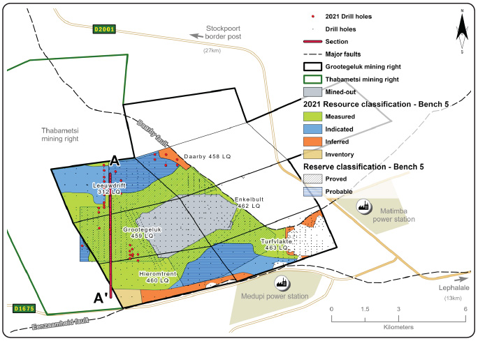
| Location | 25km west of the town of Lephalale in Limpopo, South Africa | |||
|---|---|---|---|---|
| History | Previous ownership | Material notes | ||
| 1960s to 1980 | Yskor – Iscor – Iscor mining – Kumba | Exploration drilling | ||
| 1980 to present | Kumba – Kumba coal – Exxaro Resources | Mine commissioned in 1980, continuous exploration drilling to increase Resource confidence. Mine in operation approximately 41 years. | ||
| Adjacent properties | Thabametsi to the west | |||
| Infrastructure | Grootegeluk can be reached from Lephalale via the hard-topped Nelson Mandela Drive, which is linked to the R510 road connecting Lephalale to the town of Vaalwater to the south and the Stockpoort border post between South Africa and Botswana to the north. Power supply to the mine is obtained directly from the power station via two 132kV lines that supply the mine's three 840MVA transformers. Raw water is delivered to the mine and to a water-treatment plant on the farm Zeeland by the 700mm-diameter Hans Strijdom pipeline. The pipeline originates at the Mokolo Dam. Potable water from the Zeeland water-treatment plant is in turn routed to the mine and local communities. | |||
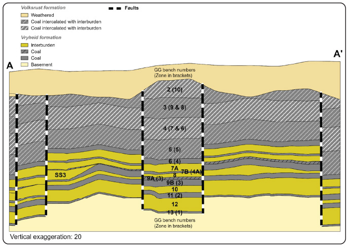
| Coalfield | Grootegeluk is located in the Waterberg coalfield and the coal seams are from the Volkrust and Vryheid formations. | |||
| Main seams | The upper part of the coal deposit, the Volksrust Formation (approximately 60m thick) is classified as a thick interbedded seam deposit type, comprising intercalated mudstone or carbonaceous shale and bright coal layers. The Vryheid Formation (approximately 55m thick) forms the lower part of the coal deposit and comprises carbonaceous shale and sandstone with interbedded dull coal seams varying in thickness from 1.5m to 9m. It is therefore classified as a multiple-seam deposit type. | |||
| Seam development | These coal seams are subdivided into 11 coal zones which are further divided into separate coal and non-coal samples for analysis. A total of 77 samples are analysed per full succession drill hole consisting of 30 coal samples and 30 non-coal samples for the Volksrust Formation and 13 coal samples and four non-coal samples for the Vryheid Formation. | |||
| Depositional control | The Zoetfontein fault forms the boundary of the Waterberg coalfield in the north while the Eenzaamheid fault forms the boundary in the south. The Daarby fault, with a throw of some 350m, divides the coalfield into a deep north-eastern portion and a shallow south-western portion. The first fresh coal in the shallow south-western portion is on average 20m below surface. The lowermost coal seam (Zone 1) occurs at a depth of about 130m in the shallow portion of the coalfield but this may vary depending on the local structure. The predominantly horizontal coal-bearing formations have a very gentle dip to the south-east near Grootegeluk. Only a few dolerite dykes outcrop in the south-eastern portion of the Waterberg coalfield and no sills have been encountered in any exploration drill holes drilled in the mine right area to date. | |||
| Resources and Reserves | The Resource extent is restricted by the depositional controls discussed above. The Reserves are restricted within the Resource blocks. | |||
| Mining method | Grootegeluk comprises of one open-pit mine, which includes two overburden benches, nine RoM benches and three interburden benches. A series of parallel benches are advanced progressively across the deposit via a process of drilling, blasting, loading and hauling with truck-and-shovel fleets. RoM is transported to the Grootegeluk beneficiation complex via haul trucks and in-pit crushing and conveying systems. | |||
| Beneficiation | Coal is beneficiated via eight different plants that produce power station coal (thermal coal) at 35% ash, variously sized metallurgical coal products at different quality specifications and semi-soft coking coal. | |||
| Product | Various sized metallurgical coal products at 15% ash and 11.25% ash, semi-soft coking coal at 10.3% ash, as well as steam coal at 12.5% ash are railed to various customers and shipped to international clients via an export harbour. A small portion of the total product is sold on site to smaller customers and dispatched by road. | |||
| Market | Local and export market. | |||
| Mining right | Grootegeluk has an approved mining right that covers some 26 325ha. | |||
| Environmental approvals | All environmental appeals have been favourably addressed for the declared Reserves. | |||
| Projects/Feasibility studies | The GGAMS project specifically refers to different methods of extracting, transporting, handling and placement of the OVB material at Grootegeluk mine by shifting it from the front of the advancing pit face to other destinations, especially the backfill area within the mined-out void of the pit. | |||
| PROCESS | INFORMATION | |||
| Drilling, logging and sampling | In order to have sufficient material available from each sample for the required suite of analyses to relative densities of 2.20g/m3, large-diameter: 123mm-diameter drill core are drilled. The large-diameter drill holes are drilled in between the existing 500m x 500m grid of small-diameter drill holes. The reason for this placement of large-diameter drill holes was that analysis of samples from the large-diameter drill holes could be used to supplement analysis of existing small-diameter drill holes where samples and density fractions were absent. Sampling of drill holes is only conducted after the stratigraphy has been correlated. The geologist in charge supervises all drill hole drilling and is responsible for logging and sampling. | |||
| Laboratory and accreditation | Bureau Veritas, SANAS T0469. | |||
| Laboratory dispatch and receiving process | Each sample submitted to the laboratory is accompanied by a unique sample number for validation and tracking, as well as a submission list that serves as a sample advice sheet with instructions for analysis. | |||
| Laboratory quality control and quality assurance | As part of the assurance and control process, audits are performed internally and externally. Bureau Veritas is accredited for analytical work and participates in monthly local and international round robins. | |||
| Data datum | WGS84 — LO27 | |||
| Drill hole database | acQuire | |||
| Number of drill holes in MR | 1240 | |||
| Number of drill holes used for Resource estimation | 1 083 | |||
| Number of drill holes used for classification | 545 | |||
| Data compositing and weighting | Conducted in acQuire | |||
| Data validation | Conducted using queries in acQuire and Excel | |||
| Geological modelling software | Geovia MinexTM | |||
| Estimation technique | Growth algorithm | |||
| Previous model date | 2016 | |||
| Last model update | 2020 | |||
| Grid mesh size | 20m x 20m | |||
| Scan distance | 2 000m | |||
| Data boundary | 200m | |||
| Model build limits | Upper: limit of weathering and topography/collar Lower: Zone 1 floor |
|||
| Model outputs | Roof, floor and thickness grids generated for structure Raw and wash quality grids | |||
| Changes to modelling process | Definition of Bench 9A to exclude sample 25 and 25S from the RoM bench | |||
| Thickness cut-off and extraction height considerations | Opencast ≤0.5m | |||
| Quality cut-offs (adb) | ≥65% ash Volksrust Formation coal, ≥50% ash Vryheid Formation coal | |||
| Geological loss applied | Variable per bench, calculated each year considering geological model estimation error and physical geological loss | |||
Table 40: Resource classification criteria
| CATEGORY | TYPE OF DRILL HOLES | DRILL HOLE SPACING | STRUCTURALLY COMPLEX AREAS | DRILL HOLES/HA | ||||||||
| Measured | Cored drill holes with applicable coal qualities | 0m to 500m | Matrix (additional geophysically logged drill holes needed to augment existing data and determine classification) | 0.1 | ||||||||
| Indicated | Cored drill holes with applicable coal qualities | 500m to 1 000m | Matrix (additional geophysically logged drill holes needed to augment existing data and determine classification) | 0.03 | ||||||||
| Inferred | Cored drill holes with applicable coal qualities | 1 000m to 3 000m | Matrix (additional geophysically logged drill holes needed to augment existing data and determine classification) | 0.03 | ||||||||
| ITEM | CRITERIA | CRITERIA MET | COMMENT | ||||||
| Geological data | Data has been validated and signed off by Competent Person | Yes | Geological structures, seam thickness ≤0.5m, ash content ≥65% ash Volksrust Formation coal and ≥50% Ash Vryheid Formation coal. Coal qualities reported on an air-dried basis | ||||||
| Geological model | Geological model has been considered and signed off | Yes | 2020 | ||||||
| Structural model | Structural model was considered and signed off | Yes | 2019 | ||||||
| Mining | Mining assumptions considered and defined | Yes | Opencast | ||||||
| Assurance | Exxaro internal audits and external audit conducted | Yes | Resource and LoM done in 2018 | ||||||
| Economic evaluation | Exploitation study with economic and mining assumptions, including geotechnical and geohydrological assumptions | Yes | Exploitation strategy over mining right | ||||||
| Environmental | Reasonable demonstration that environmental approvals can be obtained within the context of local, regional and national governmental legislation | Yes | All applicable approvals are in place | ||||||
| Tenure | Formal tenure must be demonstrated with reasonable demonstration that a mining right approval can be obtained within the context of local, regional and national governmental legislation | Yes | Mining right with no impediments noted is valid till 2041 and there is reasonable expectation that the right will be renewed | ||||||
| Infrastructure | Assumptions used should be reasonable and within known/assumed tolerances or have examples of precedence | Yes | Existing infrastructure adequate or can be upgraded with new required infrastructure under construction | ||||||
| Market | A potential market for the product with a reasonable assumption that this market is sustainable | Yes | Current CSAs for local and export markets | ||||||
Table 42: Reserve estimation
| TOPIC | INFORMATION | ||
| Software | XPAC | ||
| Reserving process | RPM Global’s XPAC mine-scheduling software is used to derive the remaining saleable Reserves from RoM Reserves in the approved pit layout. After converting the geological model’s grids to the appropriate format, the floor, roof and thickness data as well as quality data for each bench is imported into the XPAC model. In this model, validations are performed to evaluate the data for possible discrepancies, such as incremental yields anomalies for each bench, thus ensuring they rise with increases in the relative float densities. The Resource category areas are also loaded into the XPAC model for Reserve categorisation purposes. The XPAC model integrates new geometallurgical principles into the LoM planning process and scheduling model to better predict as-mined plant performance. This is an all-inclusive model that can simulate all the plants in the Grootegeluk complex from one integrated flow sheet. The washability tables for each blast block are imported into the geometallurgical model (XPAC). The geometallurgical schedule imitates reality at Grootegeluk as portions of a single blast block can be allocated to several beneficiation plants in a particular scheduling period. Once the production schedule has run, a blend of blast blocks from different benches is allocated to each plant for each scheduling period. A new composite wash table is then derived for each plant for each scheduling period, which represents the blend of material fed from the mine to that plant. This composite wash table is then used to derive the specific products required to be produced by that plant for that period. A set of calibrated plant factors is applied per plant to adjust theoretical product yields to practical expected levels. It is thus not assumed that a block in its entirety is allocated to one plant only, as this does not represent reality at Grootegeluk. The scheduled mining blocks are of the same size as current actual blast blocks in the mine. The fact that material from different benches is combined and beneficiated simultaneously creates difficulty in reporting saleable product tonnages per bench. The preferred reporting practice at Grootegeluk is therefore RoM tonnes per bench and saleable product tonnes per beneficiation plant. |
||
| Conversion classification | Indicated Resources are generally converted to Probable Reserves and Measured Resources to Proved Reserves after consideration of all applicable modifying factors. If one or more of the modifying factors have not been fulfilled, Measured Resource is either not converted or the Measured Resource is converted but downgraded to Probable and the associated risk is clearly stated. Inferred Resources are not converted to Coal Reserves. | ||
| Inferred Resources inside LoM | Some 137Mt of Inferred Resources are included in the LoM plan, representing 5.3% of the LoM plan, and are not considered material. The impact of the Inferred Resources are known with the majority thereof occurring at the tail end of the LoM plan and addressed by an integrated exploration plan that is reviewed every year. | ||
Modifying factors
| Average thickness cut-off | ≤0.5m | ||
| Quality cut-offs | ≥65% ash content (raw in situ) | ||
| Mining loss | No loss applied due to the fact that all mining boundaries are reached and no pillars are left | ||
| Boundary pillar | N/A | ||
| Dilution | Applied to in situ mineable Reserves due to the inter-layered composition of the deposit | ||
| Contamination | Varies per bench. 0 to 0.75m applied to interburden seams | ||
| Mining recovery efficiency | Varies per bench. 0 to 0.75m depending on bench height | ||
| Planned average slope angles | <61.7 degrees | ||
| Practical plant yield | Considered in the reserving process as per wash table information per combination of blocks per planning increment and the empirically determined practical yield adjustment factor | ||
| Strip ratio cut-off | Energy strip ratio >7GJ/ex-pit tonne | ||
| Environmentally sensitive areas | Areas underlying wetlands and other eco-sensitive areas are excluded from the Reserves, distance as per environmental requirements | ||
| Legal | The layout is within the mining right boundary and not closer than 15m | ||
| Social | There are no known socially sensitive areas in the pit layout (for example, graveyards and dwellings) | ||
| Geohydrological | Areas identified are flagged and excluded or reclassified in the reserving process | ||
Table 43: Grootegeluk Coal Resource and Coal Reserve statement
| Category | 2021 (Mt) |
2020 (Mt) |
Difference in tonnes (Mt) |
Difference (%) |
Reason for change |
| Measured | 2 481 | 2 532 | (52) | (2) | Reduction of 55Mt through mining depletion, increase of 2Mt from the survey adjustment relating to 2020 reporting, minor changes due to reconciliation and mining in previously sterilised areas. |
|---|---|---|---|---|---|
| Indicated | 1 421 | 1 422 | 0 | 0 | |
| Inferred | 338 | 338 | 0 | 0 | |
| Total Coal Resources | 4 240 | 4 292 | (52) | (1) | |
| Proved | 1 682 | 1 730 | (48) | (3) | Reduction of 55Mt through mining depletion, increase of 2Mt from the survey adjustment relating to 2020 reporting, 2Mt reduction due to reconciliation, 6Mt increase due to rounding of figures between the various benches. |
| Probable | 898 | 898 | 0 | 0 | |
| Total Coal Reserves | 2 580 | 2 628 | (49) | (2) |
Summary of the exploration for the reporting year can be seen in Table 44. For detailed expenditure, please refer to Table 54.
Table 44: Exploration summary
| OBJECTIVES | PROGRESS IN REPORTING YEAR | PLANS FOR NEXT REPORTING YEAR | ||||
| Primarily on geological and geotechnical overburden material characterisation for the GGAMS project. | The appointment of a new exploration drilling service provider resulted in a delay in the start-up, necessitating a revision of the exploration plan. Thirty six (36) drill holes were successfully completed during the year. Thirty one (31) percussion holes were drilled for overburden material classification and sampling. These drill holes were also used to improve delineation of faults in structurally complex areas. |
Nine thy seven (97) drill holes planned in 2022:
|
||||
Table 45: Grootegeluk risks
| RISK | DESCRIPTION | MITIGATION | ||||
| Fault position accuracy | The structure interpretation (fault positions) in the geological model is based on drill hole information that is widespread | Additional percussion drill holes are drilled in structurally complex areas after it is covered by the normal cored exploration drill hole grid. | ||||
| Removal for weathered material in the pit | If the weathered material is not removed properly, downstream problems are experienced in the beneficiation plants. | A strict block declaration procedure is followed to minimise the amount of weathered material left on a block before blasting and loading occurs. | ||||
| Semi-soft coking coal (SSCC) yield loss | The yield of the SSCC as obtained in the beneficiation plants at Grootegeluk is much lower than the theoretical yield as determined from exploration drill hole samples at Bureau Veritas laboratory. The main reason for this phenomenon is related to near density material that is inadvertently misplaced to the power station coal product and lost to slimes during the mining and beneficiation process. | Although the low actual SSCC yield has a negative impact on the mine’s profitability, it poses a low risk on the Resource because empirically calculated plant correlation factors are used in the Mine Planning department to compensate for the misplaced material in the plant. | ||||
| Power station coal sulphur content | Benches that are utilized for power station coal by means of crush and screen operations, have high sulphur concentrations. This is mainly due to the presence of pyrite nodules within the coal structure. Should this RoM material have to be beneficiated to lower the Sulphur content, an associated yield loss and additional beneficiation costs will be incurred. There will also be less dry coal material available for the management of the coal product moisture content. | To cater for the impact of pyritic sulphur in Vryheid Formation coal, the GG7 plant has the capacity to process the coarse fraction, where the pyritic sulphur typically reports. This assists in reducing the final sulphur in the product. | ||||
Grootegeluk mine continually strives to improve operational performance in all aspects. To this end, the mine has embarked on several initiatives to improve not only data accuracy, but also, readiness to assist in decision making and Resource optimisation. Building on the success of the short-term sample model, the mine is investigating the implementation of a sample-based long-term model that covers the entire Resource area and LoM thus unlocking the value in aligning actual mining conditions, increased flexibility and prevailing market conditions. In conjunction with the sample-based long-term model, the mine has implemented the OCCS mine planning software, which is a fully integrated mine planning solution that is envisaged to unlock incredible value across the MRM value chain. Lastly, the Grootegeluk Survey department has recently commissioned in-pit static scanners to augment their current survey capabilities (which include drones and mobile scanners) and to aid in in-time data collection. These scanners will aid in providing real-time data.
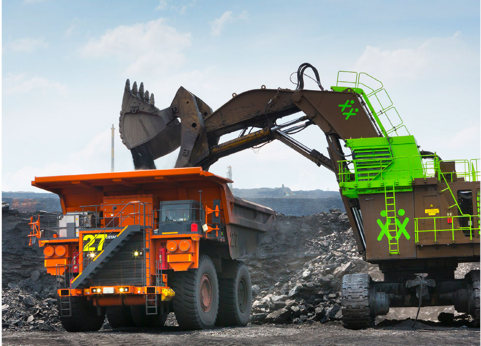
Truck and shovel at Grootegeluk