Exxaro Resources limited
Consolidated Mineral Resources and Mineral Reserves report 2021
Matla is a captive underground coal mine that extracts thermal coal that is crushed, screened and sized before it is delivered directly to the Eskom-owned Matla power station via a network of conveyor belts. There is potential to increase RoM through successfully implementing and executing the three major expansion projects that are at various stages of implementation. A major milestone was reached in 2021 for the Mine 1 relocation project through the completion of the boxcut. Through the review of the LoM and innovation from the Matla team, investigations on additional mining ground are ongoing.
Table 30: Matla overview
| TOPIC | INFORMATION | ||||
| Location | 15km west of the town of Kriel in Mpumalanga, South Africa | ||||
History 1976 to 1990 1990 to 2006 2006 to 2021 |
Previous ownership Trans Natal Mines Eyesizwe Exxaro |
Material notes Construction began in 1976 with full production in 1983 Rights ceded to Exxaro in 2006 Continuous exploration drilling. Mine in operation for approximately 38 years. |
|||
| Adjacent properties |
The well-known Kriel coal mine neighbours Matla mine to the east and the operations of Khutala (South32) and Zondagsfontein (Anglo American) to the north. |
||||
| Infrastructure |
Matla is on the P53-1 and R547 secondary roads branching off the R580 and R545. Existing infrastructure of the three shaft complexes includes three ventilation shafts, a network of conveyor belts, coal silos and stockpiles, a crushing and screening plant, four pollution-control dams, hospital, accommodation facilities, offices, workshops, and a water treatment plant. Potable water is received from Eskom and no potable water plant exists on the mine property. Electricity is sourced from Eskom (Matla power station) and transporting coal from the mine to Matla power station is via a network of conveyor belts. |
||||
| Coalfield |
Matla mine is in the Highveld coalfield, immediately south of the Witbank coalfield. The coal seams are found in the Vryheid Formation of the Karoo supergroup. The stratigraphy sequence in the Matla area includes five coal seams that can be easily correlated with seams found in the Witbank coalfield. |
||||
| Main seams |
The principal economic seams currently exploited are S2 and S4 with mining of S5 terminated in 1998 due to high levels of contamination and subsequent increase in abrasive index. |
||||
| Seam development |
Coal seams in the area are generally flat and continuous with subsequent igneous activity resulting in displacements and devolatilisation of coal seams at places. |
||||
| Depositional control |
The coal was deposited on glacial sediments of Dwyka tillite, which in turn was deposited over a granitic basement. The Matla mining area is characterised by two distinct dolerite types, the B8 (porphyritic) and B4 (olive-rich) types which have varying effects on seam displacements and coal burning and devolatilisation. A dolerite sill with an average thickness of 10m is generally found above S5 in mines 2 and 3. However, the sill intersects the coal seams and underlies S2 in Mine 1 and S4 on the south-western part of the Reserves. This sill has burned and devolatilised S2 on the southern part of the mining area in Mine 1. Floor rolls have been encountered in S2 workings and created some challenges in some mining sections. The floor rolls strike north-east-south-west, vary in width between 50m and 200m and have amplitudes up to 1.5m. The floor rolls are more prominent if the seam floor is close to the basement contact. Sandstone lenses encountered are generally less than 0.5m in width but can reach up to 1.5m in thickness. |
||||
| Resources and Reserves |
Coal Resources and Reserves occur within the domains of mines 1, 2 and 3. The Coal Reserves are aligned with the existing LoMP. |
||||
| Mining method |
Matla comprises three underground production facilities: Mine 1, Mine 2 and Mine 3. All three are long-life assets, each with a specific operating capacity comprising conventional coal circuits to produce bituminous coal. Work at Mine 1 was stopped in 2015 due to pillar instability but an Eskom-approved project to relocate |
||||
| TOPIC | INFORMATION | |||
| Beneficiation |
None of the coal mined at Matla is beneficiated but is crushed and screened (sized) before being conveyed to the power station. |
|||
| Product |
Matla mine produces thermal coal exclusively for Eskom. |
|||
| Market |
Captive market: Eskom |
|||
| Mining right |
Matla has an approved mining right that covers some 23 494ha. |
|||
| Environmental approvals |
All environmental appeals have been favourably addressed for the declared Reserves except for one that has expired but is under renewal. |
|||
| Projects/Feasibility studies |
Three major LoM projects exist at Matla, namely the Matla Mine 1 relocation project (MM1R), the Northwest Access Decline project (NWA decline) and the Northwest Access Incline project (NWA incline). The MM1R is currently in progress and includes the construction of a boxcut, portals, silos and overland conveyors which creates a new access point to Mine 1, with conveyor infrastructure transporting the coal directly to Matla Power Station. The NWA projects are two separate projects where a decline and incline will be constructed at Mine 3 and Mine 2 respectively to unlock future Coal Reserves. The NWA incline is currently in progress where the incline connects existing Seam 2 workings to the 4 Seam to allow extraction of the 4 Seam through Mine 2. |
|||
Figure 11: Matla mine
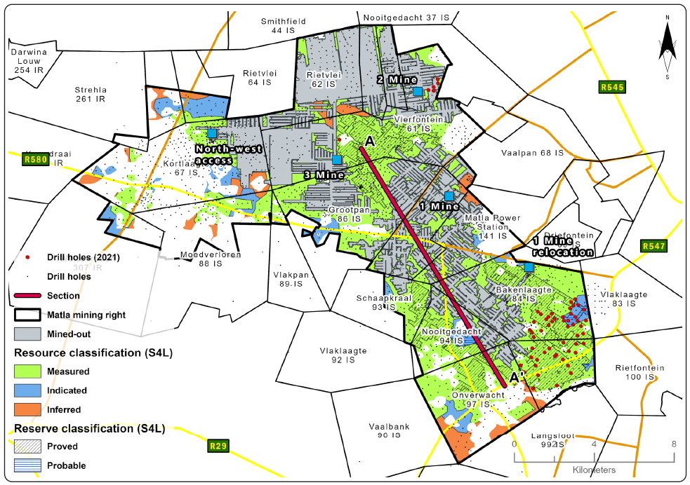
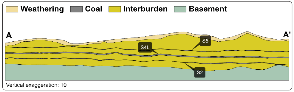
Figure 12: Matla cross-section
Resource estimation
Table 31: Resource estimation methodology and reporting
| TOPIC | INFORMATION | |||
| Drilling, logging and sampling |
Surface vertical, surface inclined and underground horizontal drilling methods are employed at Matla. Of these, only the vertical surface drill holes are used for resource modelling. All drill holes are geologically logged on a detailed log sheet with the content dictated by the Exxaro logging procedure. Logging is conducted by recording of lithology down to 1cm detail on logging sheets, according to the classification of the lithology. Once all core and sample markings are in place, the core is photographed on a 1m interval basis. Once correlated, sample intervals are defined based on lithological contacts and logical boundaries along the drill hole, across the named intervals or seams. If the entire unit is homogenous samples are then collected at 1.5m intervals. All samples are placed into plastic sample bags, and a sample tag is placed inside the bag, with a duplicated attached to a cable tie on the bag's exterior. The sample tags are used to identify the samples according to a sampling convention, which is recorded in the log sheet and geological database as to allow the laboratory results to be assigned to the correct interval in each specific drill hole. |
|||
| Laboratory and accreditation |
Siza Coal laboratory, SANAS T0447 |
|||
| Laboratory dispatch and receiving process |
All samples collected and bagged are registered in a sample sheet which is also used as a dispatch sheet. All exploration samples are weighed on site prior to dispatch and recorded at the mine. The laboratory reports the weight of each individual sample, and these results are compared to the mine weights to validate that the correct samples were conveyed correctly and safely to the laboratory. The dispatch sheet is signed by the receiving laboratory personnel after ensuring that the number and sample ID on the dispatch sheet matches that of the actual samples that should be analysed. The analyses required are also clearly explained in the sample dispatch sheet. |
|||
| Laboratory quality control and quality assurance |
Matla conducted QA/QC on Siza laboratory processes and equipment in 2020. Siza laboratory also does internal validations and checks as part of their QA/QC programme. Siza partakes in round robins. |
|||
| Data datum |
Cape datum - LO29 |
|||
| Drill hole database |
acQuire |
|||
| Number of drill holes in mining right |
3 321 |
|||
| Number of drill holes used for Resource estimation |
S2 – 2 523 S4 – 2 222 |
|||
| Number of drill holes used for classification |
S2 – 1 659 |
|||
| Data compositing and weighting |
Conducted in Geovia MinexTM |
|||
| Data validation | Conducted using queries in acQuire and Excel | |||
| Geological modelling software | Geovia MinexTM | |||
| Estimation technique | Growth algorithm | |||
| Previous model date | 2019 | |||
| Last model update | 2020 | |||
| Grid mesh size | 25m x 25m | |||
| Scan distance | 2 000m | |||
| Data boundary | 200m | |||
| Model build limits | Upper: limit of weathering and topography/collar Lower: basement/Dwyka |
|||
| Model outputs | Roof, floor and thickness grids generated for structure Raw quality grids |
|||
| Changes to modelling process | None | |||
| Thickness cut-off and extraction height considerations | ≤1.8m and ≥4.8m | |||
| Quality cut-offs (adb) | DAFV ≤26% CV ≤15MJ/kg, Ash ≥50% |
Geological loss applied |
10% (may vary considering RODA) |
|
Table 32: Resource classification criteria
| CATEGORY | TYPE OF DRILL HOLES | DRILL HOLE SPACING | STRUCTURALLY COMPLEX AREAS | DRILL HOLES/HA | ||||||||
| Measured | Cored drill holes with applicable coal qualities | 0m to 350m | Infill drilling is conducted where basement highs and or seam structure creates uncertainty around continuity. | S4 – 0.1 S2 – 0.1 |
||||||||
| Indicated | Cored drill holes with applicable coal qualities | 350m to 500m | Infill drilling is conducted where basement highs and or seam structure creates uncertainty around continuity. | S4 – 0.1 S2 – 0.1 |
||||||||
| Inferred | Cored drill holes with applicable coal qualities | 500m to 1 000m | Infill drilling is conducted where basement highs and or seam structure creates uncertainty around continuity. | S4 – 0.1 S2 – 0.4 |
||||||||
Table 33: RPEEE considerations
| ITEM | CRITERIA | CRITERIA MET | COMMENT | ||||||
| Geological data | Cored drill holes with applicable coal qualities | Yes | Seam depth ≤40m, seam thickness ≤1.8m and ≥4.8m, dry ash-free volatiles ≤26%, air-dried CV≤19.5MJ/kg and ash ≥50% with coal qualities reported on an air-dried basis. | ||||||
| Geological model | Geological model has been considered and signed off | Yes | 2020 | ||||||
| Structural model | Structural model was considered and signed off | Yes | 2020 | ||||||
| Mining | Mining assumptions considered and defined | Yes | underground | ||||||
| Assurance | Exxaro internal audits and external audit conducted | Yes | 2019 (model and chain of custody) | ||||||
| Economic evaluation | Exploitation study with economic and mining assumptions, including geotechnical and geohydrological assumptions | Yes | LoM exploitation study | ||||||
| Environmental | Reasonable demonstration that environmental approvals can be obtained within the context of local, regional and national governmental legislation | Yes | Current required approvals in place or there is reasonable expectation that outstanding approvals will be granted. Additional requirements can be demonstrated in the context of local, regional and national legislation. Land acquisitions for future stooping can be achieved based on the current acquisition strategy. | ||||||
| Tenure | Formal tenure must be demonstrated with reasonable demonstration that a mining right approval can be obtained within the context of local, regional and national governmental legislation | Yes | The mining right expires in 2025. Application to renew is in process and there is reasonable expectation that it will be extended with no impediments noted. | ||||||
| Infrastructure | Assumptions used should be reasonable and within known/assumed tolerances or have examples of precedence | Yes | Current infrastructure | ||||||
| Market | A potential market for the product with a reasonable assumption that this market is sustainable | Yes | Current coal supply agreement (CSA) in place until 2023. Negotiations to renew are in process. Exxaro has reasonable that the CSA will be renewed. | ||||||
Table 34: Reserve estimation
| TOPIC | INFORMATION | ||
| Software | XPAC | ||
| Reserving process | Scheduling of the Coal Reserve is determined using mine scheduling applications from XPAC and ProgCad. The geological 3D model used for the Coal Reserve estimation is referred to as the Reserve 3D model. The Coal Resource model uses the full coal seam while the Reserve model only defines a select mining height. The process ensures the model represents reality regarding the technical capability of current production equipment. Resources are converted to Reserves where the Resource confidence, continuity and other factors (including economic, environmental, safety and social aspects) allow for the reasonable expectation of successful extraction. Reserves are converted using modifying factors which account for layout design and associated losses. The Reserves stated are subject to verification according to an approved fact pack, which sets out the standards and considerations for all reserving and scheduling processes. This document is reviewed annually and vetted by all relevant stakeholders. |
||
| Conversion classification | At Matla, Indicated Resources are generally converted to Probable Reserves and Measured Resources to the Proved Reserve category, except if any modifying factors have not been (partly) fulfilled, where the Resource is either not converted or downgraded to the Probable Reserve category, clearly stating the outstanding requirement and risk. | ||
| Inferred Resources inside LoM | Some 7.6Mt of Inferred Resources are included in the LoMP, representing 4.7% of the LoMP, and are not considered material. | ||
Modifying factors
| Average thickness cut-off | ≤1.8m and ≥4.8m | ||
| Quality cut-offs | DAFV ≤26% and CV ≤19.5MJ/kg | ||
| Mining loss | Already included in model, based on specific geological conditions and mining restrictions | ||
| Depth to roof | 40m unless rock strength allows otherwise | ||
| Safety factor | Tertiary panels 1.6 and main development 2.0 | ||
| Bord width | 7.2m | ||
| Barrier pillar | At least equal to pillar width | ||
| Boundary pillar | 15m | ||
| Mining height | ≤1.8m and ≥4.8m | ||
| Extraction factor | Already included in model | ||
| Dilution | Already included in model | ||
| Contamination | Use select seam | ||
| Practical plant yield | N/A | ||
| Strip ratio cut-off | N/A | ||
| Environmentally sensitive areas | Areas underlying wetlands and other eco-sensitive areas are excluded from Reserves. A higher safety factor is used underneath rivers and surface structures. | ||
| Legal | Applicable mining right considered | ||
| Social | Applicable mining right considered | ||
| Geohydrological | Applicable surface and groundwater models considered. | ||
Table 35: Matla Coal Resource and Coal Reserve statement
| Category | 2021 (Mt) |
2020 (Mt) |
Difference in tonnes (Mt) |
Difference (%) |
Reason for change |
| Measured | 639 | 694 | (55) | (8) | Reduction of 8Mt through depletion and 47Mt reduction due to the removal of isolated remnant coal blocks that did not meet the RPEEE criteria. |
|---|---|---|---|---|---|
| Indicated | 114 | 123 | (9) | (7) | Reduction of 1Mt through depletion and 9Mt reduction due to the removal of isolated remnant coal blocks that did not meet the RPEEE criteria. |
| Inferred | 93 | 151 | (58) | (38) | Reduction of 2Mt through depletion and 55Mt reduction due to the removal of isolated remnant coal blocks that did not meet the RPEEE criteria. |
| Total Coal Resources | 847 | 968 | (122) | (13) | |
| Proved | 124 | 148 | (24) | (16) | Mining depletion 5Mt, 4Mt reduction due to LoMP changes relating to areas of burnt coal and 15Mt downgraded to Probable Reserve due to surface land ownership required for stooping. |
| Probable | 38 | 22 | 16 | 74 | Mining depletion 1Mt and 2Mt increase due to LoMP changes related to new information and the remainder is due to reclassification from Proved Reserves. |
| Total Coal Reserves | 162 | 169 | (7) | (4) |
Summary of the exploration for the reporting year is outlined in Table 20. For detailed expenditure, refer to Table 54.
Table 36: Matla exploration sum
| OBJECTIVES | PROGRESS IN REPORTING YEAR | PLANS FOR NEXT REPORTING YEAR | ||||
| Increase geological confidence in S2L Mine 3 area | Surface directional drilling was conducted in the main development access of the planned low seam LoM to ascertain dyke behaviour and coal continuity. |
Areas with dykes and fractured coal zones, which were identified through directional drilling, will be targeted in the 2022 vertical exploration campaign. |
||||
| Infill drilling in planned future mining areas of Mine 2 and Mine 3 (S2 western resource) | Infill drilling was conducted at Mine 2 Eastern Reserves to confirm coal continuity and quality. | Further drilling is planned for the Mine 2 Eastern Reserves as well as the Mine 3 S4 medium-term mine plan. | ||||
| Mine 2 S4 project area dolerite definition and displacement delineation | Surface directional drilling was conducted in 2020, which was used to redefine the mine design for the 2021 reporting year. | No drilling is planned in this area for 2022. | ||||
Table 37: Matla risks
| RISK | DESCRIPTION | MITIGATION | ||||
| Eskom purchasing of surface farms to commence with stooping | Require ownership of farms where stooping is planned. | Eskom to purchase surface ownership of a list of farms as per CSA. | ||||
| Environmental authorisation for stooping | The environmental management plan for total extraction on stooping can only start if the surface land belongs to Eskom. | Eskom needs to purchase ownership of a list of farms as per CSA. | ||||
| Geological structures | Geological faulting as well as the impact of sill and dykes are very pertinent challenges in all three of the Matla mine expansion projects. Unforeseen geological structural complexity (faulting and intrusives) poses risk for specifically the low seam Reserves at mines 2 and 3. Geological faults with a significant offset have been encountered and they have production tempo impacts in the mining sections. | The challenges are addressed through a suite of exploration activities. Challenges are proactively accommodated in mine planning. Continuous surface exploration drilling aims to improve sill characterisation in Mine 2 while underground horizontal drilling is used to pinpoint dykes in operating sections at mines 2 and 3. | ||||
| Limited pit room due to project execution delays | Approximately 83% of the current Reserves are within the expansion projects. Delays in funding or execution may delay access to Reserves. | Continuous investigations on accessing new mining areas that were previously excluded from the LoM either due to quality, structural complexity or geological confidence. | ||||
Due to the structural complexity at Matla, surface to seam directional drilling was implemented as an investigative tool to detect structures that affect mining operations. The success of detecting structures, using this tool, has assisted in redefining LoM in the affected areas. It has also enabled targeted vertical exploration drilling thus restricting drilling to areas of interest.
Mining ground availability has become a key focus area at Matla due to delays in three major LoM projects. Over the past three to four years, additional Reserves have been unlocked at Mine 3 Seam 4, Mine 2 Seam 2 and Mine 3 Seam 2 mining areas to ensure continued production while project implementation is ongoing. These additional Reserves have included the delineation of low seam coal at Mine 3, as well as shortwall mining at Mine 2 with the aim of increasing production tonnes from the mine, in conditions never attempted anywhere in the world.