Exxaro Resources limited
Consolidated Mineral Resources and Mineral Reserves report 2021
Leeuwpan mine has two opencast pits in operation and multiple face exposure for mining flexibility, which can be linked to the current market-to-resource strategy. The review of the LoM together with low production, due to the market-to-resource strategy, has resulted in eight remaining operational years. Exxaro is currently in a process of potential divestment from the operation.
Table 22: Leeuwpan overview
| RISK | INFORMATION | |||
| Location | 10km south-east of the town of Delmas in Mpumalanga, South Africa | |||
| History | Previous ownership | Material notes | ||
| 1988 to 2006 | Iscor – Iscor mining – Kumba | Exploration began in 1990, first box-cut was commissioned in 1992 and rights ceded to Exxaro in 2006. | ||
| 2006 to 2021 | Exxaro | Infill exploration drilling. Mine in operation for approximately 29 years. | ||
| Adjacent properties | Stuart Colliery, Delta Mining Company and HCI Khusela Coal are coal mines owning property in close proximity to Leeuwpan. Silica mine is also adjacent to Leeuwpan. | |||
| Infrastructure | Leeuwpan lies alongside the R50 hard-topped secondary road and is serviced by a rail track that includes a rapid load out station. Electricity is supplied directly to the mine by Eskom by means of a substation at Witklip which is linked to the nearby Eskom power line. Potable water is supplied from drill holes, which are used only for drinking water. Process water is supplied from a closed system, which includes the plant, slimes dams and pit dams. Water replenishment comes from the pits but, if this is insufficient, make-up water from six drill holes is also used. | |||
| Coalfield | Leeuwpan mine is in the Delmas coalfield, on the western border of the Witbank coalfield. The geology within the Delmas coalfield is similar to that of the Witbank coalfield. |
|||
| Main seams | Two coal seams have been identified at Leeuwpan: top coal seam and bottom coal seam. The bottom coal seam correlates with the S2 of the Witbank and Highveld coalfields and the top coal seam correlates with the S4 and S5. The bottom coal seam qualities are generally higher than the top coal seam qualities. | |||
| Seam development | The coal seams at Leeuwpan are primarily interbedded with sandstone, shale and carbonaceous shale. | |||
| Depositional control | The coal was deposited on glacial sediments of Dwyka tillite, which in turn was deposited on dolomite of the Transvaal supergroup. A significant amount of magma intruded as concordant sills of dolerite in the Karoo strata in the Delmas area. Associated with the dolerite intrusion are numerous thin dolerite dyke structures that transgress the stratigraphy. Factors controlling geological and quality continuity are mainly surface weathering, significant variation in seam thickness due to an undulating tillite floor, faulting associated with dolerite activity and dolomitic basement, and devolatilisation and weathering due to dolerite intrusions (sills and dykes). | |||
| Resources and Reserves | Coal Resources occur in opencast pits OI, OL and UB, and Reserves occur within the same pits and are aligned with the existing LoMP. | |||
| Mining method | Leeuwpan is an opencast operation with various Reserves, in various pits, mined simultaneously. Current mining operations are on the OIW, OL and OI Reserves. The mine uses trucks and shovels for mining-related operations. | |||
| Beneficiation | Leeuwpan has two dense medium separation plants that beneficiate export thermal coal and two dry plants, crush-and-stack and bypass plants that handle selectively mined thermal coal either for the local market or the export market. The second dense medium separation plant, commissioned in 2016 is operated by Fraser Alexander whereas the original plant is operated by Exxaro. | |||
| Product | Both plants are geared for 5 300kcal/kg production. The crush-and-stack and bypass can produce either 5 300kcal/kg, 4 800kcal/kg or 4 200kcal/kg products. | |||
| Market | Leeuwpan supplies domestic and export markets. | |||
| Mining right | Leeuwpan has an approved mining right that covers 4 269ha. | |||
| Environmental approvals | All environmental appeals have been favourably addressed for the declared Reserves. | |||
| Projects/Feasibility studies | None | |||
Figure 9: Leeuwpan mine
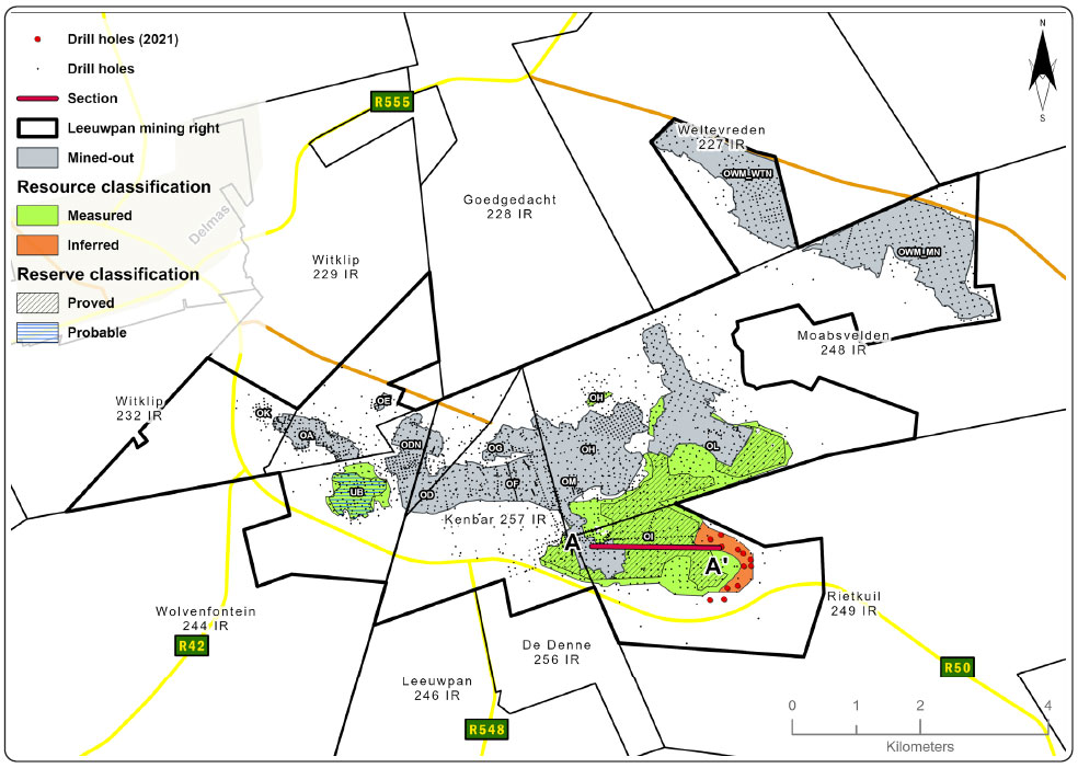
Figure 10: Leeuwpan cross-section through pit OI
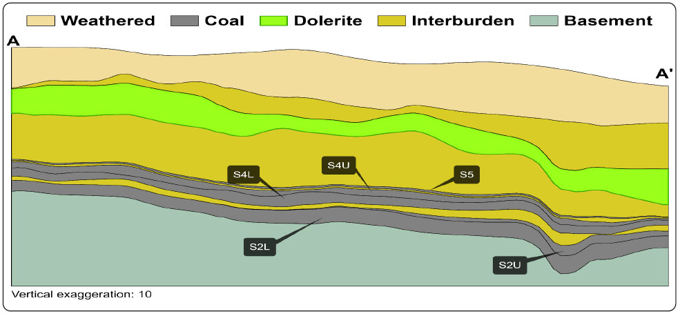
Table 23: Resource estimation methodology and reporting
| PROCESS | INFORMATION | |||
| Drilling, logging and sampling | Vertical surface drill holes are drilled and subsequently logged on site. Lithological codes are used when capturing the lithology. Photographs of the core are taken after marking the core. Samples are split on the lithological contact, if needed, using a chisel and hammer to ensure a clean break. Each sample is put in an individual bag with all material represented in that interval, ensuring no contamination occurs between materials to be sampled. Two sample tags are marked using a permanent marker. One sample tag is placed inside the bag and the second on the outside of the bag then sealed with a cable tie. | |||
| Laboratory and accreditation | SGS, SANAS T0561 | |||
| Laboratory dispatch and receiving process | All samples collected and bagged are registered in a sample sheet, which is also used as a dispatch sheet. The dispatch sheet is signed by the receiving laboratory personnel after ensuring that the number and sample ID on the dispatch sheet matches that of the actual samples to be analysed. Once the laboratory receives and signs the dispatch sheet, it is responsible for safekeeping and storage of that batch of samples. | |||
| Laboratory quality control and quality assurance | SGS is accredited for analytical work and participates in monthly local and international round robins. | |||
| Data datum | Cape datum – LO29 | |||
| Drill hole database | acQuire | |||
| Number of drill holes in mining right | 2 993 | |||
| Number of drill holes used for Resource estimation | 612 | |||
| Number of drill holes used for classification | 492 | |||
| Data compositing and weighting | acQuire | |||
| Data validation | Conducted using queries in acQuire and Excel | |||
| Geological modelling software | Geovia MinexTM | |||
| Estimation technique | Growth algorithm | |||
| Previous model date | 2018 | |||
| Last model update | 2019 | |||
| Grid mesh size | 20m x 20m | |||
| Scan distance | 1 000m | |||
| Data boundary | 200m | |||
| Model build limits | Upper: limit of weathering and topography/collarLower: basement/Dwyka | |||
| Model outputs | Roof, floor and thickness grids generated for structure Raw and wash quality grids | |||
| Changes to modelling process | None | |||
| Thickness cut-off and extraction height considerations | 2019 model ≤0.5m (S5 ≤1m) | |||
| Quality cut-offs (adb) | Ash ≥50%, a non-material amount of coal ≥50% ash may be included to ensure optimised extraction | |||
| Geological loss applied | 5% to 100% based on geological loss domains (5% standard geological loss is applied but may vary based on the consideration of structural complexity (dolerite sill breakthrough – 50% loss within determined spatial extent and fault displacement zone – 100%) and seam floor adulation (10% loss). | |||
Table 24: Resource classification criteria
| CATEGORY | TYPE OF DRILL HOLES | DRILL HOLE SPACING | STRUCTURALLY COMPLEX AREAS | DRILL HOLES/HA | ||||||||
| Measured | Cored drill holes with applicable coal qualities | 0m to 100m | May be more conservative after consideration of RODA | 1.1 | ||||||||
| Indicated | Cored drill holes with applicable coal qualities | 100m to 200m | May be more conservative after consideration of RODA | 0.6 | ||||||||
| Inferred | Cored drill holes with applicable coal qualities | 200m to 1 000m | May be more conservative after consideration of RODA | 0.2 | ||||||||
Table 25: RPEEE considerations
| ITEM | CRITERIA | CRITERIA MET | COMMENT | ||||||
| Geological data |
Data has been validated and signed off by Competent Person | Yes | Seam depth, seam thickness ≤0.5m all seams except S5 thickness ≤1m, ≥50% ash content but a non-material amount of coal with ≤50% ash may be included to ensure optimised extraction, coal qualities are reported on an air-dried basis | ||||||
| Geological model | Geological model has been considered and signed off | Yes | 2019 | ||||||
| Structural model | Structural model was considered and signed off | Yes | 2019 | ||||||
| Mining | Mining assumptions considered and defined | Yes | Opencast | ||||||
| Assurance | Exxaro internal audits and external audit conducted | Yes | External audit by EY in 2021 | ||||||
| Economic evaluation | Exploitation study with economic and mining assumptions, including geotechnical and geohydrological assumptions | Yes | LoM exploitation study | ||||||
| Environmental | Reasonable demonstration that environmental approvals can be obtained within the context of local, regional and national governmental legislation | Yes | Current required approvals in place | ||||||
| Tenure | Formal tenure must be demonstrated with reasonable demonstration that a mining right approval can be obtained within the context of local, regional and national governmental legislation | Yes | Mining right valid to 2039 with no impediments noted | ||||||
| Infrastructure | Assumptions used should be reasonable and within known/assumed tolerances or have examples of precedence | Yes | Current infrastructure | ||||||
| Market | A potential market for the product with a reasonable assumption that this market is sustainable | Yes | Current market | ||||||
Table 26: Reserve estimation
| TOPIC | INFORMATION | ||
| Software | OCCS | ||
| Reserving process | Scheduling of the Reserve is determined using a mine scheduling application (Scheduler) from OCCS, which is the same software used to develop the LoMP schedule. The geological three-dimensional (3D) model used for the Resource statement is referred to as the Reserve geological 3D model. The geological model is supplied to mining, projects and technology in the form of MinexTM grids. The grids are then imported into a reserving application (Reserver) from the same OCCS software. This application is used to validate the geological information received by checking the integrity of the geological structure and that quality and wash-table values are consistent, and to convert the geological 3D model into mineable block sizes. Careful product selection and balancing of remaining reserves is required at Leeuwpan to ensure maximum value for Exxaro. | ||
| Conversion classification | Indicated Resources are generally converted to Probable Reserves and Measured Resources to Proved Reserves after consideration of all applicable modifying factors. If one or more of the modifying factors have not been fulfilled, Measured Resource is either not converted or the Measured Resource is converted but downgraded to Probable and the associated risk is clearly stated. This is the case for UB, where it is classified as a Probable Reserve because of additional modifying factors such as low volatiles and the limited market for this particular quality of coal. Inferred Resources are not converted to Coal Reserves. | ||
| Inferred Resources inside LoM | No Inferred Resources inside LoM. | ||
| Modifying factors | |||
| Average thickness cut-off | 0.5m all seams except S5, which is 1.0m | ||
| Quality cut-offs | N/A | ||
| Mining loss | 25% for S5 and 5% for all other seams | ||
| Boundary pillar | 100m | ||
| Dilution | 0% | ||
| Contamination | 5% on dense medium separation plants and 1% on crush and stack plant | ||
| Mining recovery efficiency | 5% (crush and stack) and 5% (dense medium separation bypass) | ||
| Planned average slope angles | 45 degrees. For highwall stability, soft material is mined at least one strip ahead of hard material and coal mining activities | ||
| Practical plant yield | 90% dense media separation and 90% Fraser Alexander dense medium separation with slimes loss on dense media separation of 9% and 15% on Fraser Alexander dense media separation. | ||
| Strip ratio cut-off | Strip ratio is determined using the energy strip ratio assessment and is considered in the reserving process using the economic model to get mining boundaries | ||
| Environmentally sensitive areas | Environmentally sensitive areas applications made, and approval acquired before mining. | ||
| Legal | Applicable mining right considered | ||
| Social | Applicable communities considered. Socially sensitive areas in the mining right (such as graveyards) are excluded from Reserves in the reserving process | ||
| Geohydrological | Applicable surface and groundwater models are considered. The pit floor was taken into consideration to minimise water handling in the pit face | ||
Table 27: Leeuwpan Coal Resource and Coal Reserve statement
| Category | 2021 (Mt) |
2020 (Mt) |
Difference in tonnes (Mt) |
Difference (%) |
Reason for change | ||
| Measured | 77.9 | 79.9 | (2.0) | (2) | Reduction by 4.6Mt due to mining depletion and increase of 2.6Mt due to Resource conversion from the Indicated category. | ||
|---|---|---|---|---|---|---|---|
| Indicated | 0.0 | 2.6 | (2.6) | (100) | Resource conversion to Measured category due to increased Resource confidence. | ||
| Inferred | 3.6 | 3.6 | – | – | |||
| Total Coal Resources | 81.5 | 86.1 | (4.6) | (5) | |||
| Proved | 40.2 | 42.0 | (1.8) | (4) | Reduction by 4.5Mt due to mining depletion, 2.5Mt increase due to Reserve reclassification from Probable, 1.3Mt increase due to model refinement, 0.4Mt reduction due to methodology and 0.7Mt reduction due to reconciliation relating to 2020 reporting. | ||
| Probable | 3.2 | 5.7 | (2.5) | (44) | Reduction by 2.5Mt is due to a change in the Resource classification to Measured. | ||
| Total Coal Reserves | 43.4 | 47.8 | (4.3) | (9) |
Summary of the exploration for the reporting year is outlined in Table 28. For detailed expenditure, refer to Table 54.
Table 28: Leeuwpan exploration summary
| OBJECTIVES | PROGRESS IN REPORTING YEAR | PLANS FOR NEXT REPORTING YEAR | ||||
| Increase Resource confidence from Inferred Resource to Measured Resource in the OI area | Twelve (12) surface vertical drill holes were drilled using conventional diamond drilling. TWN core was recovered, logged and sampled. The spacing of the drill holes was such that in the next geological model update the area's geological classification will be converted to Measured category. All the drill holes were wireline logged. | Ten (10) drill holes are planned, mainly in the OL extension, to delineate the sandstone washout zone and increase confidence in the OL-OI Bridge area. | ||||
Table 29: Leeuwpan risks
| RISK | DESCRIPTION | MITIGATION | ||||
| Dolerite sill impact on slope stability | Reserve blocks UB and OI have a dolerite sill overlying the coal strata and the sill orientation affects slope stability. | Apply RODA to identify the areas of high geological risk. The bench design is modified based on dolerite dipping towards the seam. |
||||
| Major faults | Major faults with displacements greater than the seam widths occur between OL and OI. This is also associated with sill transgression. | Inclusion in the RODA plan and higher geological losses applied to major fault zones. | ||||
| Coal quality | In seam quality deviations are generally localised and are associated with minor channel washouts. | Manage quality variability through grade control practices. | ||||
| Water accumulation | In-pit water accumulation due to excess groundwater either from the pit face or with coal exposure. | Proactive groundwater management and pit dewatering. | ||||
| Reserve losses | In OI West, along the R50, the rock engineering design requires that a safe stand-off distance is established to prevent potential slope failure and infrastructure damage (Eskom power line and national road). | Geotechnical design has been done to establish safe benching practice. Application process in progress to allow mining within 100m of power line and national road. |
||||
Operational excellence at Leeuwpan exists to focus on the continual sustainable improvement of core processes in the value chain using principles such as performance benchmarking, waste reduction, theory of constraints, productivity improvement, and new technologies on the existing processes, people and systems. The value-driven focus at Leeuwpan is on the top five initiatives, Lean 5 compliance and Digital@Exxaro innovation. The key focus remains on mining operations, plant processing and engineering to assist in improving throughput, cost reduction and safety compliance for the benefit of the entire mine value chain.