Integrated report 2019
Exxaro Resources Limited
Consolidated Mineral Resources and Mineral Reserves Report
Supplementary descriptions are provided for projects and operations directly under Exxaro's management control.
For projects and operations included in the Exxaro Mineral Resource and Mineral Reserve statement but in which Exxaro does not have management control, the reader is referred to that company's website for supplementary information (refer to foreword).
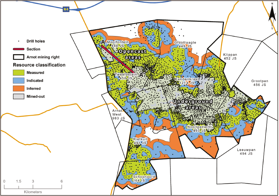
Arnot mine is situated roughly midway between the towns of Middelburg and Carolina in Mpumalanga province, South Africa. Arnot was acquired from Eyesizwe Coal with the creation of Exxaro Resources in 2006. The mine is 43km by road from Middelburg, 65km by road from Carolina and 25km from Hendrina, and is surrounded by a number of projects and active operations. Tenure from Umsimbithi Mining and the Wonderfontein coal operation as well as Mafube coal mine, a joint venture between Anglo American and Exxaro, is situated towards the north of Arnot. Universal Coal's large Arnot South project is to the south of Arnot and the in-closure Exxaro operation of Strathrae is adjacent to the east.
Arnot was contracted to supply coal to the nearby Eskom Arnot power station until 31 December 2015. This was achieved by extracting 2 seam lower (S2L) from two underground shafts, 8 and 10, using mechanised mining equipment (bord-and-pillar extraction) while Mooifontein opencast used conventional truck-and-shovel, roll-over mining method to extract S2L and 1 seam (S1). One beneficiation plant handles around 14% of the RoM and the mine is served by several good access roads, gravel and paved. The mining right area is 15 021.21 hectares and annual production in 2014 and 2015 was 1.44Mt and 1.40Mt respectively. Arnot has a mining right (MP325MR) that is executed and lapses December 2038. The operation was in closure after the coal-supply agreement lapsed.
In May 2019, Exxaro received consent from the Minister of Mineral Resources and Energy in terms of section 11 of the Mineral and Petroleum Resources Development Act 2002 (Act 28 of 2002), for cession of the mining right for the Arnot coal mine to a consortium, which will benefit its former employees following the expiry of the coal-supply agreement (CSA) with Eskom in 2015. The transfer of the mining right has not yet been completed as some conditions precedent are in the process of conclusion. Exxaro has reasonable expectation that the outstanding conditions will be achieved in the first quarter of 2020.
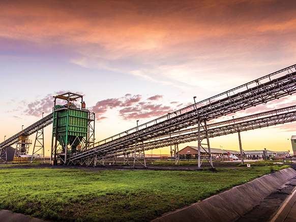
Figure 9: Arnot mine
Arnot mine produced thermal coal for over 40 years, using various mining methods, predominantly bord-and-pillar (currently mechanical), opencasting and shortwalling between 1995 and 2005. Arnot had a 40-year CSA with Eskom, supplying the adjacent Arnot power station, which ended on 31 December 2015. A prefeasibility study on the commercial viability of Arnot in 2016 found several areas that can be profitably mined for the thermal coal market. However, due to the absence of a confirmed CSA, no Reserves have been declared.
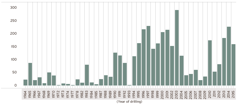
Arnot's Coal Resource has been extensively drilled from 1964 by various companies using a combination of openhole, wireline logged and cored methods as well as various other prospecting techniques. Diamond coring was predominantly conducted using a smaller diameter drill bit (TNW) but large (HQ3)-diameter drilling was also employed specifically for specialised coal quality, geotechnical, geohydrological and gas-sampling investigative work. Openhole (percussion) wireline logged drilling was used for in-fill grade-control purposes to investigate the outline of geological structures and to test coal-seam structure continuity within areas already classified as Measured Resources.
Drilling was first recorded in 1964 and 6 072 vertical exploration boreholes have been drilled to date. A significant amount of historical boreholes have no known drilling information as no hard-copy or database information could be traced hence exclusion from any estimation processes. No drilling was undertaken since 2015.
The Arnot operation lies close to the eastern edge of the Witbank coalfield, close to the margin of the Main Karoo Basin in which the stratigraphic column is reduced to 80m but still contains coal seams correlating to the five classical (#1-5) Witbank coalfield seams. The pre-Karoo basement topography consists of felsites and diabase intrusives associated with the Transvaal Supergroup and Bushveld Igneous Complex respectively. The Vryheid Formation is conformably deposited on top of the reworked glacio-fluvial tillite of the Dwyka Group.
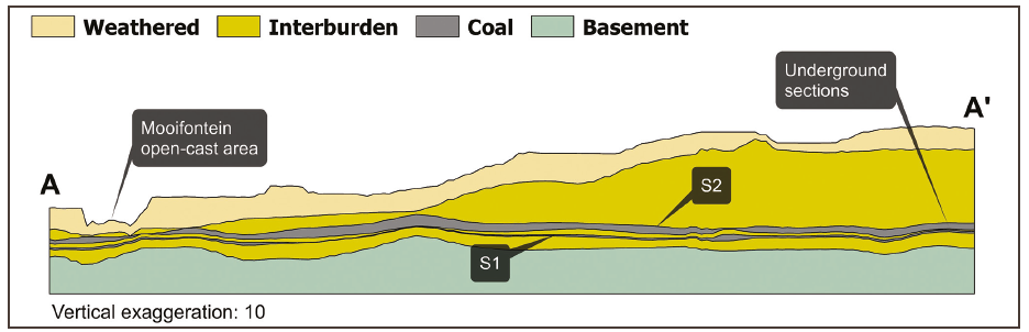
Seam 1 (S1) and seam 2 (S2) are the only coal seams of economic interest in the Arnot mining right area, and these correlate with the typical Witbank coalfield seams. The S1 is well-developed across the entire underground and opencast Resource areas. It is intersected at an average depth of over 50m in the underground areas, and the depth and undulation render it unfeasible for exploitation. It does, however, occur at shallower depths of at least 23m in opencast areas and remains a good prospect in these areas.
The S2 is the main, well-developed coal seam of economic importance at Arnot. The depth to the top of S2 depends largely on local surface topography and reaches a maximum depth of 80m along the eastern boundary of the mine lease area, and pinches and thins out in the eastern parts of the mining section due to local, pre-Karoo basement palaeo highs. This seam is generally intersected at an average depth of 44m in underground Resource areas and at average depths of 20m in opencast Resource areas. It is continuous across the Arnot mine lease area and varies from <1m to 4.5m in thickness with an average of 3.1m. S2 is site-specifically subdivided into the seam 2 lower (S2L), seam 2 upper (S2U) and seam 2A (S2A) marked by two in-seam partings, namely P2 and P3 respectively. The S2L is the only coal seam being mined in the underground Resource areas and consists of dull to lustrous coal with several bright coal bands and occasional stone partings. It has an average of 23.28MJ/kg (adb) calorific value in the underground Resource area and a 24.22MJ/kg (adb) in the opencast area, and constitutes about two-thirds of the mineable in-situ Coal Resource in the Arnot mining area.
The seam 4 (S4) occurs erratically across the mining area with an average thickness of 0.5m. The seam is often split by internal clastic partings into S4L and S4U. The seam is overlain by interlaminated units of siltstone and shale with the seam 5 (S5) sporadically developed in small areas.
A number of faults trend roughly north-east south-west with displacement of 1m to 3m are present in the Arnot mining right. However, one large pertinent thrust fault (L9) separates the southern Coal Resource area from the main Resource. Accessibility through this fault is problematic and will require specialist mining intervention. A limited number of dolerite dykes are known to have intruded the Karoo sediments in the area. Dykes in general lack magnetic signature and are not responsive to geophysical method of detection. The presence of dolerite dykes and sills has a devolatising effect on the S2L coal seam. The intersected dykes are generally thin (0.3m to 1.5m), discontinuous and sub-parallel to a sill in an east-west direction. This sill is well-developed (about 5m to 40m thick) and overlies the S2L coal seam along the south-eastern Resource boundary.
Figure 10: Arnot drilling history
All data collection (geological logging, description, interpretation, sampling, validation and capturing of borehole cores information) is undertaken by qualified, trained and competent geologists on-site and aligned with Exxaro standards. A well-trained grade-control and geological mapping team undertake mapping and reconciliation. Mapping captures intrusions, devolatilised coal, channel sandstones/in-seam partings, slumping structures, faults, joints, guttering, slabbing and floor rolls as well as measurements of mined heights, contamination and dilution. Dips and dip directions of all geological features and structures are measured, recorded and digitalised into Bentley MicroStation v8i. Surface mapping was only conducted where outcrops were observed.
Core loss for coal-seam intersections is recorded and a recovery of <95% through coal (by volume) is deemed unsatisfactory. Anomalies were investigated and redrilled, if required. Wireline logging results are only available for more recent boreholes. Underground boreholes at Arnot are bull-nose boreholes. A diamond drill bit is used to produce chips instead of core and changes in lithology are easily detected by changes in penetration rates. In addition, 1.5m core samples are taken every 20m to confirm the lithology in this regard.
Logging is conducted by recording lithology down to centimetre scale according to the classification of the various coal "lithofacies"/coal type zones or ply (shale-coaly, coal-shaly, coal dull, coal mixed/mainly dull, coal mixed, coal mixed/mainly bright and coal bright) based on the discernible visible lithofacies change and identified marker horizons, particularly through coal zones. All holes were captured in Micromine Geobank© SQL geological database information system but migrated in 2017 to acQuire Technology Solutions Proprietary Limited.
All core sampling is done at the drill sites. The samples are selected according to their respective coal seam boundaries after a thorough correlation. In-seam partings made seam and sample correlation challenging and the geologist applied discretion to ensure best correlation and sampling fit. A general rule of >0.5m seam sample thickness cut-off is applied but evaluated in-field where necessary. In addition, the proposed mining method, mining equipment and sample mass (chemical and physical analysis required) are also considered. In-seam partings are sampled together with the coal zone samples, especially the PL parting (after considering thickness) in the S2L zone.
Two distinct horizons are sampled in the S2L, and these are often distinguished by the variable and discernible vitrinite content and/or the PL parting. Each sample is assigned a unique sample number, bagged and tagged separately for each seam interval to minimise contamination or errors. The samples are dispatched to the coal assay laboratory within three days to minimise moisture loss and variation and another possible coal-property deterioration.
All bore samples (up to 2015) are sent to Siza Coal Services Laboratory, a Middelburg-based SANAS-accredited testing laboratory with a full ISO/IEC 17025:2005 certification (last samples submitted in 2014). Arnot and the applicable laboratory reviewed the Yanka round-robin system (to ensure that the laboratory's proficiency testing schemes are still in line with other independent laboratories on reproducibility and repeatability of results).
Drill core samples are dried in an oven before being crushed and screened at -13mm, +0.5/-0.5mm size fractions for physical analysis, and down to -212↔m for chemical analysis. The collected sample is divided into two: one half is for physical analysis (for example, ad hoc abrasive index testing) and the other half is for chemical analysis (such as proximate analysis and calorific value). Float and sink analyses (washabilities) of the screened -13mm and +0.5mm particle size distributions are then performed at five relative densities (RDs), namely 1.40g/cm3, 1.50g/cm3, 1.60g/cm3, 1.70g/cm3 and 1.80 g/cm3. Full proximate, calorific value and total sulphur analyses are performed at each RD fraction. Reference samples are stored for at least three months before disposal.
Figure 11: Typical north-south (A-A) section through Arnot geological model
The reported estimation is based on the 2015 geological model, which was the last updated model when operations stopped. Some 2 458 boreholes with applicable analysis were selected from the extensive database based on specific criteria and used for Resource estimation, using Minex general gridding. Coal-quality compositing was conducted in Geovia MinexTM on a weighted average basis and signed-off substitute values were used for unsampled in-seam material. The average estimated raw relative density was used for tonnage estimation. In general, a 10% geological loss was applied but the loss factor may vary depending on the consideration of structural complexity, intrusions and level of weathering (application of RODA).
The Resource classification methodology, although fundamentally based on SANS 10320, is based on a matrix approach that incorporates borehole spacing, type of boreholes and structural complexity in the Resource.
Table 12: Arnot Coal Resource reporting criteria
| Thickness cut-off (reporting and extraction height considerations) |
Quality cut-offs (adb) | Geological loss | ||
| OC <1.0m | Ash >50% | Applied per domains ~10% (RODA) | ||
| UG <1.8m | Ash >50% |
Table 13: Arnot Coal Resource estimation criteria
| Item | Description | ||
| Database | Borehole database | acQuire | |
| Data datum | Cape LO29 | ||
| Number of boreholes used for Resource estimation | 2 458 | ||
| Validation | Range of standard queries to test seam structure and quality | ||
| Data compositing and weighting | Geovia MinexTM | ||
| Model | Previous model date | 2014 | |
| Last model update | 2015 (ARN 2015) | ||
| Geological modelling software | Geovia MinexTM | ||
| Last peer review | 2015 | ||
| Estimation technique | Growth algorithm | ||
| Grid mesh size | 25m x 25m | ||
| Scan distance | 2 000m | ||
| Data boundary | 200m | ||
| Model build limits | Upper: limit of weathering and topography/collar Lower: basement/Dwyka |
||
| Model outputs | Roof, floor and thickness grids generated for structure Raw quality grids |
||
| Changes to modelling process | None |
Table 14: Arnot Coal Resource classification criteria
| Category | Type of boreholes | Borehole spacing | Structurally complex areas | |||
| Measured | Cored boreholes with applicable coal qualities | 0m – 350m | May be more conservative after consideration of RODA | |||
| Indicated | Cored boreholes with applicable coal qualities | 350m – 500m | May be more conservative after consideration of RODA | |||
| Inferred | Cored boreholes with applicable coal qualities | 500m – 1 000m | May be more conservative after consideration of RODA |
Table 15: Arnot Resource statement
| Category | 2019 (Mt) (OC) |
2019 (Mt) (UG) |
2018 (Mt) (OC) |
2018 (Mt) (UG) |
Difference (%) |
|---|---|---|---|---|---|
| Measured | 20.2 | 118.3 | 20.2 | 118.3 | — |
| Indicated | 18.9 | 45.4 | 18.9 | 45.4 | — |
| Inferred | 8.8 | 12.5 | 8.8 | 12.5 | — |
| Total Coal Resources | 47.9 | 176.2 | 47.9 | 176.2 | — |
Rounding of figures may cause computational discrepancies.
Table 16: Arnot RPEEE considerations
| Item | Criteria | Considered | Arnot-specific comment | |||
| Geological data | Data validated and signed off by competent person | Yes | 2015 version | |||
| Geological model | Geological model considered and signed off | Yes | Geological structure and depositional extent, seam thickness >1.80m (UG) and >1.0m (OC), <50% ash content with coal qualities reported on an air-dry basis | |||
| Structural model | Structure model considered and signed off | Yes | 2015 version | |||
| Mining | Mining assumptions considered and defined | Yes | Underground and opencast | |||
| Assurance | Minimum tier 1 assurance (Exxaro governance) | Yes | 2015 | |||
| Economic evaluation | A concept-level exploitation with economic and mining assumptions, including geotechnical and geohydrological assumptions | Yes | Prefeasibility study conducted for mineral rights area | |||
| Environmental | Reasonable demonstration that environmental approvals can be obtained within the context of local, regional and national governmental legislation | Done | The dispute in the Exxaro/Eskom coal-supply agreement for the shortfall in the rehabilitation provision fund was resolved by arbitration with an award in favour of Exxaro. Exxaro further made the arbitration award an order of court | |||
| Tenure | Formal tenure must be demonstrated with reasonable demonstration that a mining right approval can be obtained within the context of local, regional and national governmental legislation | Yes | Compliant mining right while mine is in closure | |||
| Infrastructure | Assumptions should be reasonable and within known/assumed tolerances or have examples of precedence | Done | Current infrastructure | |||
| Market | Potential market for product with reasonable assumption that it is sustainable | Done | Good quality Coal Resource with reasonable understanding between mining operator and Eskom to unlock any potential challenges and lead to coal extraction |
No Coal Reserves are declared because of the absence of a CSA. Known occurrence of dykes, geological faults, weathering and seam thickness and quality variability are known. The occurrence and thickness of in-seam partings are highly variable and create significant challenges in underground mining sections. Continuous and focused infill openhole wire-logged drilling in panels is employed to address these risks.