Integrated report 2019
Exxaro Resources Limited
Consolidated Mineral Resources and Mineral Reserves Report
Dorstfontein (DCM) complex forms part of ECC and is on the northern margin of the Highveld coalfield along the boundary of the Smithfield Ridge, the boundary between the Highveld and Witbank coalfields.
DCM complex is 36km south of the town of eMalahleni and, to the south-west, the property borders the town of Kriel. It is in the Highveld magisterial district, under the jurisdiction of the eMalahleni local council, Mpumalanga, South Africa. DCM operations can be reached via the hard-topped R544/R547 roads linking the towns of Witbank and Kriel. DCM is surrounded by mineral right tenure owned by Kusile Mining to the west, the Universal Coal NCC operation to the north, the Kriel-East operation to the south and Mbuyelo Coal to the east.
The complex covers a total rights area of 7 892ha comprising the underground Dorstfontein West Mine (DCMW) and opencast Dorstfontein East Mine (DCME). Seams being exploited are mainly seam 4 (S4) divided into seam 4 upper (S4U) and seam 4 lower (S4L) and S2 divided into seam 2 upper (S2U) and seam 2 lower (S2L). DCMW exploited the S2 through underground bord-and-pillar method during the reporting year. With the S2 Reserves coming to an end, the operation has moved upwards to exploit the S4L through an incline development from the current S2 working. DCME is the only opencast mine in the ECC stable. However, where thicker than 1.0m, the seam 5 (S5), seam 3 (S3) and seam 1 (S1) are also extracted. Mining activities use a truck-and-shovel method to expose and extract coal. The LoM plan entails the introduction of underground extraction of S4L via an adit from one of its pits' highwalls.
A major high-tension power line from the Komati power station crosses the property, in a south-westerly direction, over the northern part of the farm Fentonia 54IS and then swings westward over portions 1, 2 and 9 of the farm Dorstfontein 71IS. A secondary high-tension power line runs along the southern boundary of the farm Welstand 55 IS and continues over portions 2 and 3 of the farm Fentonia 54IS.
DCMW mining infrastructure extends over a portion of the farm Rietkuil 558 IS and portion RE 3 of the farm Dorstfontein 71IS while DCME mining infrastructure lies on portion 11 of the farm Welstand 55 IS. Surface infrastructure consists of mine buildings (offices, workshops and change houses), a box-cut to access the coal seams, conveyor belt systems, coal-washing plant, pollution-control dams, coal stockpile areas, truck-loading facilities with weighbridges, discard dumps and a rapid coal-loading facility (rapid-loading terminal) linked to the main Richards Bay Coal Terminal. DCMW mainly supports the inland market (ferrochrome and charring plants). However, screened product from DCMW is trucked to DCME, forming part of its export product. Historically, DCME has always catered only for the export market but since 2019, it has supported both the domestic Eskom and export markets. DCMW RoM is beneficiated in a heavy medium coal-washing plant for various sizes. Final plant product is screened and classified into large nuts, small nuts, jumbo peas, peas and duff. RoM from DCME is also beneficiated in a heavy medium coal-washing plant to produce a product that depends on the coal characteristics and contractual requirements.
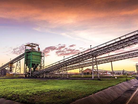
Figure 20: Dorstfontein complex

DCM complex mining and prospecting rights cover some 7 892ha, which have been explored since the 1950s. To date, 2 049 boreholes have been drilled. However, the 2017 geological model was built using 1 580 boreholes with wash-quality information and excluding the remaining boreholes based on a rigorous data-validation process. As a result of the long history of ownership and various exploration companies some boreholes cannot be directly correlated with a certain company or date drilled as the boreholes logs do not always have the relevant information.
Table 40: Dorstfontein operation history
| Date range | Company | Material notes | |||
| 1956 | Natal Navigation Collieries Proprietary Limited jointly with Estate Company Proprietary Limited | Widespread drilling of 13 boreholes on the farms Dorstfontein 71IS, Welstand 55IS and Rietfontein 43IS |
|||
| 1970 | Anglo American Proprietary Limited | Drilling of 37 boreholes for more detailed cover | |||
| 1974 - 1975 | South Cape Exploration Proprietary Limited | 86 boreholes drilled and 340 samples analysed | |||
| 1976 - 1978 | Sun Mining and Prospecting Proprietary Limited, an Anglovaal exploration company | 82 boreholes drilled and 328 coal samples analysed for washing characteristics | |||
| 1980 - 1982 | Anglovaal Proprietary Limited | 100 boreholes drilled on the farm Dorstfontein 71IS | |||
| 1996 - 1998 | Anglovaal Proprietary Limited | Drilling of 105 boreholes on the southern portion of the farm Dorstfontein 71 to support a feasibility study of the S2 mining operation at DCMW for first coal in 1997 | |||
| 1999 - 2004 | Total Exploration South Africa (TESA) | TESA took over the DCMW operation | |||
| 2004 - 2007 | Dorstfontein Coal Mines Proprietary Limited | Total Coal South Africa (TCSA) emerged from TESA. Continuous drilling for exploration and mine planning purposes. In 2007, 140 boreholes drilled for the feasibility study of the proposed S4 mining operation at DCMW. An additional 25 boreholes drilled for specialised analysis | |||
| 2008 - 2015 | Dorstfontein Coal Mines Proprietary Limited | Since 2008, a total 1 022 boreholes drilled in both areas where ECC holds prospecting and mining rights. First coal was recorded at DCME in 2011 | |||
| 2015 - 2019 | Dorstfontein Coal Mines Proprietary Limited | Exxaro acquired TCSA in 2015. The feasibility study for DCMW S4L project was approved as a replacement for the current DCMW S2L operations. A total of 201 boreholes were drilled |
Coal measures of the Highveld and Witbank coalfields are hosted in the Ecca Group, which includes the Vryheid and Volksrust coal-bearing formations. All coal seams in the ECC area are hosted in the Vryheid formation which ranges in thickness from 80m to 300m. There are five major coal seams present in the area, named from the base upwards as S1, S2, S3, S4 and S5.
A granitic basement high, which forms part of the Smithfield Ridge and is referred to below as the Central plateau, divides the DCM complex into two separate geological domains and the western and eastern limbs can be found on either side of this plateau. S1 is only developed in the central portions of the paleo-valleys, ranging in thickness from 0.1m to 2.5m. Underground extraction of this seam is considered uneconomic due to its highly variable thickness, inferior quality, isolated occurrence and coal devolatilisation. In the DCM complex, seam splitting is generally a provenance of detrital material resulting largely from the proximity of the seam to the Smithfield Ridge and, as a result, the S2 and S4 are further subdivided into S2L, S2U and S4L and S4U, respectively.
S2L is thinnest over palaeo-highs and thickest over troughs of palaeo-valleys. Two S2L thickness domains exist in the complex. In the west (DCMW), seam thickness ranges from 0.1m to 5m and, in the east (DCME) from 0.2m to 6.0m. In the north of DCMW, the S2L exists as a single coal horizon, generally devoid of stone partings. To the south of this block, an arenaceous parting splits the seam into an upper and lower subseam. The parting separating S2U and S2L in both the west and east attains a maximum thickness of 4.5m and, in the northern portion, a minimum of 0.2m with an average of 1.5m. S2U is considered uneconomic to mine separately by underground methods but is included for the opencastable blocks. Generally, S2L is the thicker of the two subseams and has better quality coal. As such, S2L is theoretically the mining target. However, practical mining of S2L is often problematic due to parting between two subseams S2L and S2U.
On the basis of seam thickness and coal quality, S4L is the main underground exploitation target in S4, which comprises coal and minor in-seam partings, and is characteristically banded with alternating dull and bright coal. The seam contains one in-seam parting of significant thickness and lateral extent with a thickness average of 0.2m but can reach 0.5m. Generally, the average thickness of S4L is 3.0m. S4U has an average thickness of 1.7m in the west and, in the east, the thickness is generally more than 1.0m, reaching 3.0m in the centre of the palaeo-valley. Seam S4U has a higher ash content and thus lower CV compared to S4L. Thickness of the S5 is generally over 1.5m. Due to a significant parting, the seam is considered uneconomic for underground extraction but can be considered for selective extraction in opencast.
Numerous Jurassic dolerites (dykes and sills) intrude the Vryheid formation at various stratigraphic levels in the area. These intrusions negatively influence the stratigraphy and coal qualities in places. The distribution of the lower coal seams are strongly influenced by basement topography while distribution of the upper seams is controlled by present-day topography. Most affected by basement topography are S1 and S2. Seams are often thin and sometimes pinch out over and against palaeo-highs. Strata (including coal) are often faulted, although displacements are rarely more than 1m. Structural displacements, resulting from intrusions of dolerite sills through seams, often complicate mining seams.
The DCM complex geology and grade continuity are largely influenced by palaeo-topography, present-day topography, surface weathering, seam thickness variation (mainly between DCMW and DCME), in-seam parting, in-seam washouts, dolerite intrusions in the form of sills and dykes, resulting in minimal to extensive zones of devolatilisation. These geological risks are well managed through extensive drilling in areas of concern, using downhole wireline logging for better definition, underground channel sampling incorporated as points of observation in the short-term model, underground face mapping generally used to track both vertical and lateral variations in the lithology to assist with reconciliations as well as structural interpretation and surface mapping, particularly of basement outcrops. The information collated from the various approaches is incorporated in the structural model, together with additional potential risks from other disciplines and represented in a GIS-based risk and opportunity domain analysis (RODA), allowing for a more integrated approach to risk management.
All exploration boreholes are logged and sampled by experienced on-site geologists aligned and complying to logging and sampling standards and standard operating procedures. Samples are selected according to seam boundaries, visual variation in the vitrinite content, assisted by density logs, and non-coal material present in the seam boundaries. Each sample submitted to the laboratories is accompanied by a unique sample number for validation and tracking as well as a submission list that serves as a sample advice sheet with instructions for analysis. Three major laboratories have been used over the past 10 years: Australian Laboratory Services (ALS), Societe Generale de Surveillance (SGS) and CoalLab (Cotecna), all with SANAS accreditation (T0611, T0815 and T0612 respectively). All three laboratories have committed to assuring the quality of results provided to the customer by ensuring quality assurance, quality control, data validation and proficiency testing procedures are observed.
The Coal Resource classification methodology is fundamentally based on SANS 10320 and considers borehole spacing, type of boreholes and structural complexity of the Resource.
Table 41: Dorstfontein Coal Resource reporting criteria
| Thickness cut-off (thickness and extraction height considerations) |
Quality cut-offs (adb) | Geological loss* | ||
| Opencast ≤0.5m Underground ≤1.2m |
Dry ash free volatiles (DAFV) ≤24% Raw ash ≥50% |
10% – 50% (domains) |
| * | A 10% standard geological loss is applied but may vary based on the consideration of structural complexity (dolerite sill breakthrough - 50% loss within determined spatial extent), seam gradient (>4 degrees – 50% loss) and dolerite sill proximity to seam (25% loss). |
Figure 21: Typical southwest-northeast section through Dorstfontein geological model
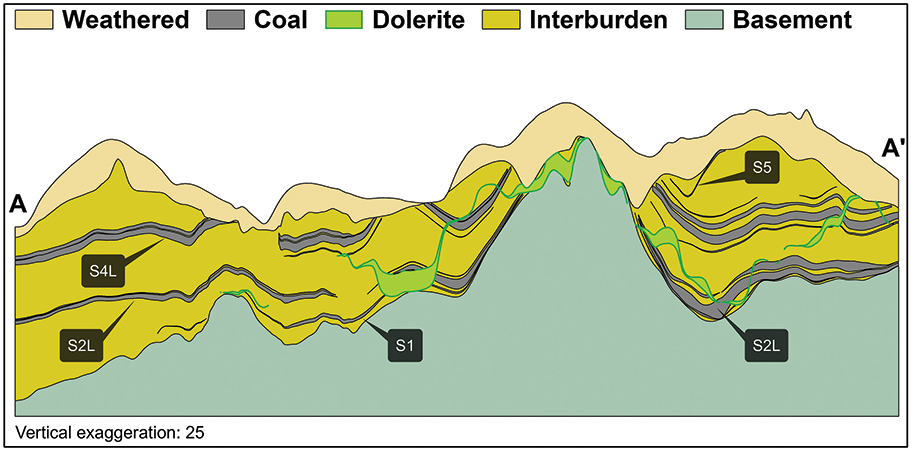
Table 42: Dorstfontein Coal Resource estimation criteria
| Item | Description | ||||
| Database | Borehole database | Sable Data Warehouse | |||
| Data datum | Cape LO29 | ||||
| Number of boreholes used for Resource estimation | 1 580 of 2 049 boreholes in the database | ||||
| Validation | The laboratory conducts data validation on samples. In the Sable Database Warehouse, additional validations are conducted and corrected. Data is exported from Sable into csv files where additional checks are done in Excel | ||||
| Data compositing and weighting | Data compositing is conducted per seam using a weighted value from the individual samples that make up the seam along with the RD and length of each individual sample. This is done in Geovia MinexTM | ||||
| Model | Previous model date | 2016 | |||
| Last model update | 2017 (peer review in 2017) | ||||
| Geological modelling software | Geovia MinexTM | ||||
| Estimation technique | Growth algorithm | ||||
| Grid mesh size | 25m x 25m | ||||
| Scan distance | 2 000m | ||||
| Data boundary | 200m | ||||
| Model build limits | Upper: limit of weathering and topography/collar Lower: basement/Dwyka |
||||
| Model outputs | Roof, floor and thickness grids generated for structure with raw quality and washability grids | ||||
| Changes to modelling process | None |
Table 43: Dorstfontein Coal Resource classification criteria
| Category | Type of boreholes | Borehole spacing | Structurally complex areas | Borehole/ha | |||||||
| Measured | Cored boreholes with applicable coal qualities | 0m – 350m | Structural complexity and coal variability (RODA) additional infill drilling | 0.49 | |||||||
| Indicated | Cored boreholes with applicable coal qualities | 350m – 500m | Structural complexity and coal variability (RODA) additional infill drilling | 0.10 | |||||||
| Inferred | Cored boreholes with applicable coal qualities | 500m – 1 000m | Structural complexity and coal variability (RODA) additional infill drilling | 0.06 |
Table 44: Dorstfontein Coal Resource and Reserve statement
| Category | 2019 (Mt) |
2018 (Mt) |
Difference in tonnes (Mt) |
Difference (%) |
Reason for changes | ||
| Measured | 149.1 | 156.4 | (7.3) | (5) | The decrease is the result of mining of DCMW (1.5Mt) and DCME (2.5Mt) respectively, the disposal of S2L barrier pillars and remnant blocks from DCMW (4.3Mt) as well as reconciliation done on an unaccounted area mined (1.6Mt) from Pit 3 mined in 2018. | ||
| Indicated | 135.5 | 137.5 | (2) | (1) | |||
| Inferred | 52.1 | 52.8 | (0.7) | (1) | |||
| Total Coal Resources (UG and OC) |
336.7 | 346.7 | (10) | (3) | |||
| Proved | 46.5 | 54.3 | (7.8) | (14) | The increase of Reserves in Pit 1 NW Extension 1.4Mt as a result of environmental approvals obtained is offset by mining (1.3Mt and 2.2Mt from DCMW and DCME respectively), the disposal of remnant S2 boundary pillars at DCME and mine layout refinements at both operations (~4.6Mt). | ||
| Probable | 41.5 | 40.5 | 1.0 | 2 | |||
| Total Coal Reserves (UG and OC) |
88.0 | 94.8 | (6.8) | (7) | |||
| Rounding of figures may cause computational discrepancies. | |
| • | All changes more than 10% are explained. |
| • | Mining method: opencast (OC) and underground (UG). |
| • | Figures are reported at 100% irrespective of percentage attributable to Exxaro. |
| • | Tonnages are quoted in metric tonnes and million tonnes is abbreviated as Mt. Coal Resources are quoted as mineable tonnes in-situ (MTIS) and refer to remaining Resources after 31 December 2019 and 31 December 2018. |
| • | Coal Resources are reported on a MTIS basis. |
| • | Cut-offs applied as per Resource reporting criteria table. |
| • | Coal Resources are quoted inclusive of Coal Reserves. |
Table 45: Dorstfontein RPEEE considerations
| Item | Criteria | Considered | Comment | |||||
| Geological data | Data has been validated and signed off by competent person | Yes | Geological structure and depositional extent, seam thickness >1.2m (UG) and >0.5m (OC), <50% ash content and >24% DAFV with coal qualities reported on an air-dry basis | |||||
| Geological model | Geological model was considered and signed off | Yes | ||||||
| Structural model | Structural model was considered and signed off | Yes | ||||||
| Mining | Mining assumptions considered and defined | Yes | OC and UG areas defined and aligned with exploitation strategy | |||||
| Assurance | Minimum tier 1 assurance (Exxaro governance) | Yes | Compliance updated in 2018 | |||||
| Economic evaluation | Concept-level exploitation with economic and mining assumptions, including geotechnical and geohydrological assumptions | Yes | Only approved economic assumptions and parameters are applied | |||||
| Environmental | Reasonable demonstration that environmental approvals can be obtained within the context of local, regional and national governmental legislation | Yes | Environmental and social concept assessment is done, applications and approvals are considered | |||||
| Tenure | Formal tenure must be demonstrated. Reasonable demonstration that a mining right approval can be obtained within the context of local, regional and national governmental legislation | Yes | Mining and prospecting rights licences are valid. Extensions or annexations will be lodged when necessary with reasonable expectations that the applications will be granted | |||||
| Infrastructure | Assumptions used should be reasonable and within known/assumed tolerances or have examples of precedence | Yes | Current infrastructure is considered | |||||
| Market | Market(s) identified - form part of an existing operation market strategy or potential market for which a conceptual market study exists | Yes | Operational strategies are aligned with existing markets |
Scheduling of the Reserve is determined using mining scheduling applications from XPAC. This is the same software used to develop the LoM plan schedule.
The geological 3D model used for the Reserve statement is referred to as the Reserve geological 3D model. This Reserve model differs from the Resource model as the latter uses the full coal seam (with specific reporting assumptions) while the Reserve model uses a select mining height based on practical mining heights and other modifying factors. The process ensures that the model represents practical aspects of the capabilities of production sections and their equipment.
Indicated Resources are generally converted to Probable Reserves and Measured Resources to Proved Reserves after consideration of all applicable modifying factors. If one or more of the modifying factors have not been fulfilled, Measured Resource is either not converted or the Measured Resource is converted but downgraded to Probable and the associated risk is clearly stated. Inferred Resources are not converted to Coal Reserves.
A total of 0.9Mt of Inferred Resource is included in the LoM plan, which is around 0.9% of the LoM plan. The majority is located along main developments that serve as access to future Reserve blocks well beyond the first five years of LoM. The impact of including these Coal Resources is well understood and tested, and exploration activities are planned to upgrade these categories to a higher level.
Table 46: Dorstfontein production figures
| Actual 2018 |
FC 2019 |
Actual 2019 |
FC 2020 |
FC 2021 |
||
| DCME RoM (Mt) | 1.85 | 2.44 | 2.20 | 2.29 | 2.58 | |
| DCMW RoM (Mt) | 1.04 | 1.11 | 1.28 | 1.83 | 1.83 | |
| DCM complex RoM (Mt) | 2.89 | 3.56 | 3.48 | 4.11 | 4.41 |
Table 47: Dorstfontein modifying factors considered in converting Coal Resources to Coal Reserves
| Considerations | Underground | Opencast | |||
| Geological loss | 10% – 25% | 10% – 25% | |||
| Average thickness cut-off | 1.4m | 1.0m | |||
| Quality specification | 5 200kcal/kg | 5 200kcal/kg | |||
| Mining loss | 0.05m | 0.1m | |||
| Depth to roof | 15m | 0 | |||
| Safety factor | 1.6 – 2.0 | 0 | |||
| Bord width | 6.5m | 0 | |||
| Barrier pillar | At least equal to the panel pillar width | 0 | |||
| Boundary pillar | 15m | 15m | |||
| Pillar centres | 14m x 14m | 0 | |||
| Mining height | 1.4m | 0 | |||
| Extraction factor | 65% | 0 | |||
| Dilution | Already included in model | Already included in model | |||
| Contamination | 0.05m | 0.10m | |||
| Practical plant yield | Considered in reserving process | Considered in reserving process | |||
| Environmentally sensitive areas | Areas underlying wetlands and other eco-sensitive areas are excluded from Reserves. A higher safety factor is used underneath rivers and surface structures | 50m cut-off away from opencast mining activities | |||
| Legal | Mining right boundary | ||||
| Social | Considered in reserving process | ||||
| Geohydrological |
DCME pits 1, 2 and 3 and Vlakfontein areas are affected by dolerite activity. Risk in these areas has been accommodated in mine planning by assigning higher geological loss values to areas reasonably expected to incur losses caused by dolerite activity. Reporting of Coal Resources on the Rietkuil Vhakoni prospecting right (1916PR) is currently under review with regard to RPEEE considerations.
The implementation of the incline at DCMW to access the thicker, although somewhat lower quality, S4L was completed and mining is progressing well.
The introduction of in-house computerised mine planning capabilities involves the building of short-term mining models that will incorporate roof and floor lithologies, as well as economic assumptions for reporting purposes, enabling quick response time on adapting to the actual mining conditions.