Integrated report 2019

Exxaro Resources Limited
Consolidated Mineral Resources and Mineral Reserves Report
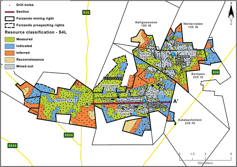
Forzando (FZO) complex, consisting of the Forzando North (FZON) and Forzando South (FZOS) operations and contiguous prospecting rights, is in the north-eastern corner of the Highveld coalfield, separated from the Witbank coalfield by the pre-Karoo Smithfield Ridge.
FZO complex is in Mpumalanga province, some 10km north of the town of Bethal. The complex is also some 55km and 77km from two major urban cities, eMalahleni and Middelburg, respectively. Major forms of transport include road and railway networks that operate throughout the year. Major roads servicing the area are R35 and R542. The complex is adjacent to several other mineral tenures, including the Anglo-American Coal project of Elders to the north and prospects of Canyon and Continental Coal to the south. Two provincial roads run through the property: Bethal-Middelburg tarred road lies just west of the area and Bethal-Hendrina tarred road passes along the extreme eastern edge. Three secondary, all-weather dirt roads traverse the area.
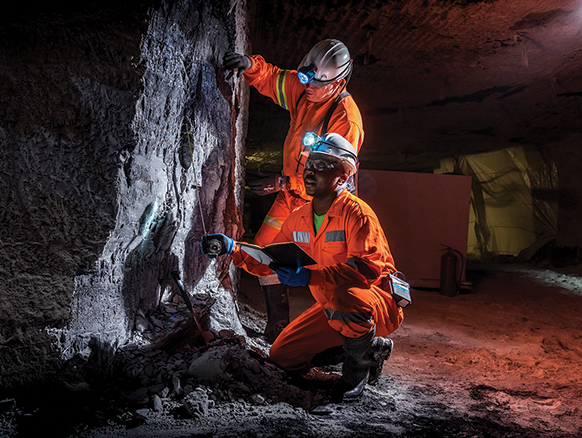
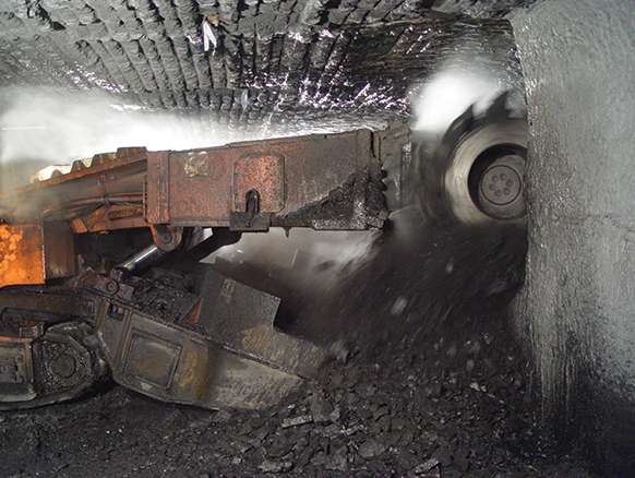
The complex covers 12 113ha and comprises two underground operations, namely Forzando North Colliery (FZON) and Forzando South Colliery (FZOS). FZOS is characterised by mechanised bord-and-pillar mining using a suite of continuous mining (CM) equipment. The operation is currently exploiting the seam 4 lower (S4L) with five CM sections and is supported by a fleet of primary and secondary mining equipment. FZOS is in its fourteenth year of operation. FZON also uses mechanised bord-and-pillar mining using a suite of CM equipment to exploit primarily the S4L, although seam 2 lower (S2L) was also previously exploited. After operating for 20 years, FZON was placed under care and maintenance in February 2014. It was recommissioned in October 2018 with one CM section targeting the S4L, investigations are currently under way to determine the viability for the future of the operation.
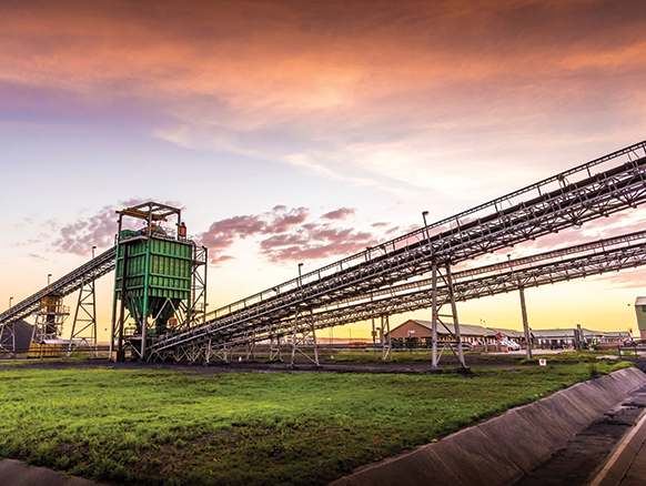
Surface infrastructure still in use includes: mine buildings (offices, workshops and change houses), box-cuts to access the coal seam, conveyor belt systems, two coal-washing plants and a rapid coal-loading facility (rapid loading terminal) linked to the main Richards Bay Coal Terminal via a privately owned railway loop.
RoM from FZOS is conveyed by surface to the beneficiation plant at FZON. Both operations support the export market. Discard from FZON is rewashed to add to the coal product mix.
Figure 22: Forzando complex
The complex has been exploited since the late 1960s with several companies undertaking drilling campaigns.
FZO complex mining and prospecting rights cover 12 113ha. To date, 2 573 boreholes have been drilled with only 1 937 falling in the respective FZO rights. The 2017 geological model was built using 1 386 boreholes with wash-quality information. In general, FZO complex has a borehole distribution of 0.11bh/ha as per classification criteria in the table below. Exploration has been conducted through diamond core and open wirelined (percussion) drilling as well as surface geophysical magnetic surveys.
As a result of the long history of ownership and various exploration companies some boreholes cannot be directly correlated with a certain company or date drilled as the boreholes logs do not always have the relevant information.
Table 48: Forzando operation history
| Date range | Company | Material notes | |||
| 1966 – 1969 | Anglo American Corporation | The first company to conduct an exploration programme, approximately 34 boreholes drilled | |||
| 1995 – 1998 | Anglovaal Minerals | FZO complex was acquired by Anglovaal Minerals in 1980s. Exploitation of S4L started in 1995 at FZON. Approximately 322 boreholes drilled | |||
| 1999 – 2004 | Total Exploration South Africa (TESA) | TESA took over the operations and exploitation of S4L continued at FZON. Approximately 1 082 boreholes drilled | |||
| 2005 – 2015 | Total Coal South Africa (TCSA) | Further exploration work was conducted by TCSA. Exploitation of S4L started in 2006 at FZOS. FZON placed was placed under care and maintenance in February 2014. Approximately 320 boreholes drilled | |||
| 2015 – 2019 | Exxaro Coal Central (ECC) | TCSA became ECC after it was taken over by Exxaro in August 2015. FZON reopened in October 2018 after being on care and maintenance for five years. 147 boreholes drilled |
Highveld coalfield hosts up to five coal seams in the middle Ecca Group sediments of the Karoo Supergroup. The stratigraphic sequence in the mine area includes five coal seams that can be correlated with seams found in the Witbank coalfield, named from the base upwards as seam 1 (S1), seam 2 (S2), seam 3 (S3), seam 4 (S4) and S5. Seam splitting is common feature in the area. This is fundamentally attributed to the proximity to the Smithfield Ridge and thus the provenance of detrital material. S2 may be split into seam 2 upper (S2U) and seam 2 lower (S2L) while S4 is split into three subseams, seam 4 lower (S4L), seam 4 upper (S4U) and S4A. Furthermore, S4A may be split into S4A1 and S4A2. S5 is generally split into the S5 and seam 5 lower (S5L).
The thickest and most ubiquitous being the S2, S4 and S5 seams. S1 is restricted to palaeo-lows while S3 only occurs on the western side of the complex. The principal economic seams currently exploited are S2L and S4L, with the remaining seams being either too thin, laterally discontinuous, poor quality or impractical/uneconomical to mine.
FZO complex is characterised by two adjoining palaeo-valleys, one in FZON and the other in FZOS. The valley in FZON has higher-quality coal while FZOS is characterised by lower-quality coal. The different coal qualities are indicative of different depositional environments and thus the different geological domains. Remnants of the Smithfield Ridge exist in the north-western edge of FZON and northern extremity of Schurvekop.
S2 occurs over most of the Forzando area, except for areas of extreme palaeo-highs along the Smithfield Ridge, along the central portion and in an isolated palaeo-hill in the north-east of the complex. The seam varies in thickness from under 1.0m to over 6.0m, with siltstone and sandstone parting typically found in areas where the seam thickness exceeds 3.5m.
The seam has been extensively devolatilised, leaving disconnected pockets of unaffected coal. Within these pockets, coal quality is extremely variable with high ash content resulting from the prevalence of thin shaly partings. The lack of continuity of unburnt coal renders it of no economic value.
Throughout the area the S4 consists, from top down, of S4A (a gritstone parting), S4U (siltstone and coarse-grained sandstone parting) and the S4L. In the east, the siltstone and coarse-grained sandstone below have been eroded, leaving only the overlying grit. Both S4A and S4U are rarely thick enough and too poor in quality to be considered economic. S4L is the only seam that is thick enough, of sufficient quality and developed throughout the area to warrant economic extraction in prevailing economics. In the FZO complex area, the thickness of the seam ranges from 0.5m to 4.0m with an average of 2.1m.
The total FZO area has been intruded by Karoo dolerites even though the impact on S4 is comparatively small and confined to those areas where they come close to or intersect the seams. Transgressive sills with a thickness of 5m to 30m have been noted, resulting in extensive burning of coal in areas, particularly where the sill either closely underlies or overlies the seam. Seams are also burnt and devolatilised near the sill transgression zones with burnt zones ranging from a few metres to 20m.
Dolerite dykes and stringers with a thickness ranging from 0.5m to 5.0m are commonly encountered in the FZO complex. Dolerite structures have a tendency to pinch and swell, even over very short distances. Dolerite stringers are thought to be offshoots from the dykes which in turn feed from the dolerite sills below. Dykes in the area are noted as having a general preferred orientation of north-west to south-east and north-east to south-west. Burnt coal zones associated with dykes/stringers vary considerably from zero to ±10m with the width of the burnt zone not necessarily relating to the thickness of the dyke/stringer. These geological risks are well managed through extensive surface vertical and underground horizontal drilling in areas of concern, use of downhole wireline logging for better correlation, underground channel sampling incorporated in the short-term planning model, underground face mapping to track both vertical and lateral variations in the lithology, which assists with reconciliations and structural interpretation, and surface mapping, particularly of basement outcrops.
The information collated from the various approaches is incorporated in the structural model, together with additional potential risks from other disciplines and represented in a GIS based risk and opportunity domain analysis (RODA), allowing for a more integrated approach to risk management.
All exploration boreholes are logged and sampled by on-site experienced geologists, aligned and complying to Exxaro standards and standard operating procedures. Samples are selected according to seam boundaries, visual variation in the vitrinite content (assisted by density logs) and non-coal material present in the seam boundaries. Each sample to be submitted to the laboratory is accompanied by a unique sample number for tracking and a submission list that also serves as a sample advice sheet with instructions for analysis.
Three major laboratories have been used over the past 10 years: Australian Laboratory Services (ALS), Societe Generale de Surveillance (SGS) and Bureau Veritas (BV), all with SANAS accreditation (T0611, T0815 and T0313, respectively). ISO and South African National Standards (SANS) have a standard set of tests and methods used for coal analysis by South African laboratories. The noted laboratories have committed to assuring the quality of results provided to the customer by ensuring quality assurance, quality control, data validation and proficiency testing procedures are observed.
The Coal Resource classification methodology is fundamentally based on SANS 10320 and considers borehole spacing, type of boreholes and structural complexity of the Resource.
Table 49: Forzando Coal Resource reporting criteria
| Thickness cut-off (reporting and extraction height considerations) |
Quality cut-offs (adb) | Geological loss1 | ||
|
Opencast ≤0.5m Underground ≤1.2m |
DAFV ≤24% Raw ash ≥50% |
10 – 50% |
| 1 | A 10% standard geological loss is applied but may vary based on the consideration of structural complexity (dolerite sill breakthrough – 50% loss within determined spatial extent), seam gradient (>4 degrees – 50% loss) and dolerite sill proximity to seam (25% loss). A 15% geological loss is applied (weighted average of the various risk domains). |
Figure 23: Typical west-east section through Forzando geological model
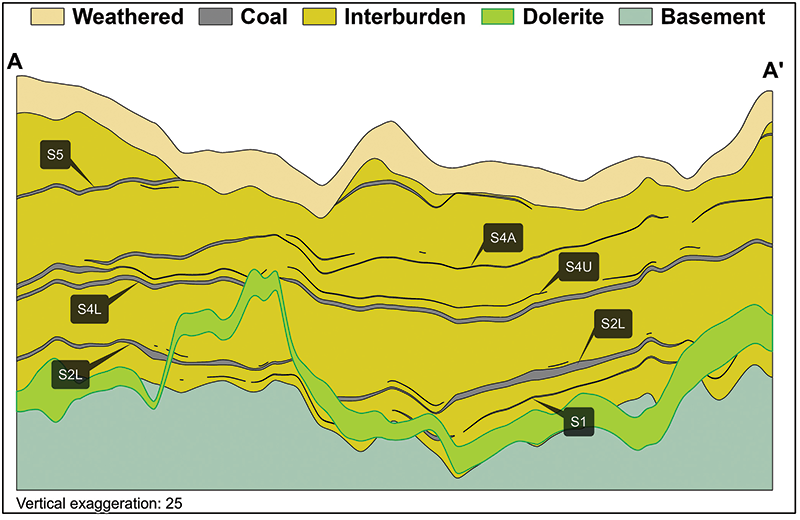
Table 50: Forzando Coal Resource estimation criteria
| Item | Description | ||||
| Database | Borehole database | Sable Data Warehouse | |||
| Data datum | Cape LO29 | ||||
| Number of boreholes used for Resource estimation | 1 386 of 1 937 boreholes in the database with washability data | ||||
| Validation | The laboratory conducts data validation on samples. In the Sable Database Warehouse, additional validations are conducted and corrected. Data is exported from Sable into csv files where additional checks are conducted in Excel | ||||
| Data compositing and weighting | Data compositing is conducted per seam using a weighted value from individual samples that make up the seam, along with the relative density and length of each individual sample. This is conducted in Geovia MinexTM | ||||
| Model | Previous model date | 2016 | |||
| Last model update | January 2017 | ||||
| Geological modelling software | Geovia MinexTM | ||||
| Estimation technique | Growth algorithm: general purpose gridding | ||||
| Grid mesh size | 25m x 25m | ||||
| Scan distance | 2 000m | ||||
| Data boundary | 200m | ||||
| Model build limits | Upper: limit of weathering and topography/collar Lower: basement/Dwyka |
||||
| Model outputs | Roof, floor and thickness grids generated for structure with raw quality and washability grids | ||||
| Changes to modelling process | None |
Table 51: Forzando Coal Resource classification criteria
| Category | Type of boreholes | Borehole spacing | Structurally complex areas | Borehole/ha | |||||||
| Measured | Cored boreholes with applicable coal qualities | 0m – 350m | Structural complexity and coal variability (RODA) | 0.15 | |||||||
| Indicated | Cored boreholes with applicable coal qualities | 350m – 500m | Structural complexity and coal variability (RODA) | 0.07 | |||||||
| Inferred | Cored boreholes with applicable coal qualities | 500m – 1 000m | Structural complexity and coal variability (RODA) | 0.02 |
Table 52: Forzando RPEEE considerations
| Item | Criteria | Considered | FZO applicable comments | |||||
| Geological data | Data validated and signed off by competent person | Yes | Geological structure and depositional extent, seam thickness >1.2m (UG) and >0.5m (OC), <50% ash content, >24% DAFV with coal qualities reported on an air-dry basis | |||||
| Geological model | 2017 geological model was considered and signed off | Yes | ||||||
| Structural model | Structural model was considered and signed off | Yes | 2018 | |||||
| Mining | Mining assumptions considered and defined | Yes | Opencast and underground aligned with exploitation strategy | |||||
| Assurance | Policy-driven governance, internal and external audits | Yes | External audit in 2018 | |||||
| Economic evaluation | Concept-level exploitation with economic and mining assumptions, including geotechnical and geohydrological assumptions | Yes | Only approved economic assumptions and parameters are applied within current prefeasibility and feasibility studies | |||||
| Environmental | Reasonable demonstration that environmental approvals can be obtained within the context of local, regional and national governmental legislation | Done | Environmental and social concept assessments were considered | |||||
| Tenure | Only areas within acceptable prospecting and mining rights. In areas adjacent to existing rights where legal section application is pending with reasonable expectation of approval | Yes | Mining and prospecting rights are valid | |||||
| Infrastructure | Assumptions used should be reasonable and within known/assumed tolerances or have examples of precedence | Yes | Current infrastructure | |||||
| Market | Market(s) identified form part of an existing operation market strategy or potential market with a conceptual market study | Yes | Operational strategies are aligned with existing markets |
Table 53: Forzando Coal Resource and Reserve statement
| Category | 2019 (Mt) |
2018 (Mt) |
Difference in tonnes (Mt) |
Difference (%) |
Reason for changes | ||
| Measured | 85.5 | 81.5 | 4.0 | 5 | Mining depletion (~2.8Mt) was offset by the addition of Resource blocks in FZON and the FZON northeast area ~7.8Mt | ||
| Indicated | 36.3 | 35.9 | 0.4 | 1 | |||
| Inferred | 26.4 | 25.8 | 0.6 | 2 | |||
| Total Coal Resources | 148.2 | 143.2 | 5.0 | 3 | |||
| Proved | 23.9 | 38.6 | (14.7) | (38) | A slight increase of 1.4Mt as a result of additional Resource blocks at FZON was offset due to mining depletion (~2.9Mt), macro-economic assumptions (~11.4Mt) as well as areas excluded at FZON due to unfavourable floor gradients, consideration of geological complexities (dykes) and the disposal of mining blocks due to excessive methane encountered (~7.1Mt) |
||
| Probable | 10.7 | 15.9 | (5.2) | (33) | |||
| Total Coal Reserves | 34.6 | 54.5 | (19.9) | (37) | |||
| Rounding of figures may cause computational discrepancies. | |
| • | All changes more than 10% are explained. |
| • | Mining method: underground (UG). |
| • | Figures are reported at 100% irrespective of percentage attributable to Exxaro. |
| • | Tonnages are quoted in metric tonnes and million tonnes is abbreviated as Mt. Coal Resources are quoted as mineable tonnes in-situ (MTIS) and refer to remaining Resources after 31 December 2019 and 31 December 2018. |
| • | Coal Resources are reported on a MTIS basis. |
| • | Cut-offs applied as per Resource reporting criteria table. |
| • | Coal Resources are quoted inclusive of Coal Reserves. |
Scheduling of the Reserve is determined using mining scheduling applications from XPAC. This is the same software used to develop the LoM plan schedule.
The geological 3D model used for the Reserve statement is referred to as the Reserve geological 3D model. This Reserve model differs from the Resource model in that the latter uses the full coal seam (including specific reporting criteria) while the Reserve model uses a select mining height based on practical mining height considerations. The process ensures the model represents the practical aspects of the capabilities of current production sections and their available equipment.
Indicated Resources are generally converted to Probable Reserves and Measured Resources to Proved Reserves after consideration of all applicable modifying factors. If one or more of the modifying factors have not been fulfilled, Measured Resource is either not converted or the Measured Resource is converted but downgraded to Probable and the associated risk is clearly stated. Inferred Resources are not converted to Coal Reserves.
A total of 0.1Mt of Inferred Resource is included in the LoM plan, representing 0.2% of LoM plan. The majority is located along the boundaries of the LoM layout well beyond the first five years of LoM. The impact of including these Coal Resources is well understood and tested, and exploration activities are planned to upgrade these categories to a higher level.
Table 54: Forzando production figures
| Actual 2018 |
FC 2019 |
Actual 2019 |
FC 2020 |
FC 2021 |
||||
| FZOS RoM (Mt) | 2.02 | 2.13 | 2.14 | 1.83 | 1.82 | |||
| FZON RoM (Mt) | 0.05 | 0.81 | 0.6 | |||||
| FZO complex RoM (Mt) | 2.07 | 2.93 | 2.73 | 1.83 | 1.82 |
Table 55: Forzando modifying factors considered in converting Coal Resources to Coal Reserves
| Underground | Opencast | ||||
| Geological loss | 10% - 25% | 10% - 25% | |||
| Average thickness cut-off | 1.65m | 1.0m | |||
| Quality specification | 5 200kcal/kg | 5 200kcal/kg | |||
| Mining loss | 0.1m | 0.1m | |||
| Depth to roof | 30m, unless rock strength allows otherwise | 0 | |||
| Safety factor | 1.6 to 2.0 | 0 | |||
| Bord width | 7.2m | 0 | |||
| Barrier pillar | At least equal to pillar width | 0 | |||
| Boundary pillar | 15m | 15m | |||
| Pillar centres | 14m x 14m | 0 | |||
| Mining height | 2.1m | 0 | |||
| Extraction factor | 65% | 0 | |||
| Dilution | Already included in model | ||||
| Contamination | 0.1m | 0.1m | |||
| Practical plant yield | |||||
| Environmentally sensitive areas | A higher safety factor is used underneath rivers and surface structures together with weathering depth consideration | Coal blocks underlying wetlands and other eco-sensitive areas are excluded from Reserves and 50m cut-off away from opencast mining activities | |||
| Legal | Mining right boundary | ||||
| Social | Socially sensitive areas in the mining right (such as graveyards) are excluded from Reserves in the reserving process | ||||
| Geohydrological | Areas identified are flagged and excluded or reclassified in the reserving process | ||||
There is a high occurrence of dolerite dykes and faulting at the various Forzando operations. Applicable surface geophysical surveys, wire-logged vertical openholes and horizontal drilling are used to provide adequate cover ahead of mining panels. The reporting of Coal Resources on the Kalabasfontein prospecting rights (1170PR and 1035PR) is currently under review with regard to RPEEE considerations.
Current economic assumptions at Forzando North have resulted in a change in the marketing strategy that could influence coal production in 2020. However, long-term price forecasts indicate that the mine can revert to its original markets post-2020.
The introduction of in-house computerised mine-planning capabilities involves the building of short-term mining models that will incorporate roof and floor lithologies, as well as economic assumptions for reporting purposes, enabling quick response time on adapting to the actual mining conditions.