Integrated report 2019

Exxaro Resources Limited
Consolidated Mineral Resources and Mineral Reserves Report
The Thabametsi project is 22km west of the town of Lephalale and adjacent to Exxaro's Grootegeluk mine. The project area is divided into a northern opencastable portion, and a southern underground area. The northern portion aims to produce power-station coal for an on-site IPP as part of phase 1. A feasibility study on phase 1 was successfully concluded in 2016 and studies on extending the phase and the southern project area are ongoing. In October 2016, the South African Minister of Minerals and Energy announced that the Thabametsi power project, for which Thabametsi project has a 30-year CSA, had been selected as a preferred bidder in the first bid window of South Africa's coal-baseload IPP procurement programme. A mining right (10013MR) for a period of 30 years was granted and executed in June 2016. A section 102 of the Mineral and Petroleum Resources Development Act, submitted to include several additional minerals to coal, to correct an administrative error, was granted in July 2017 and executed in November 2017. Exxaro is currently ensuring that all compliance actions are executed.
Drilling on the Thabametsi project area began in 1979 during Iscor's regional exploration of the Waterberg. This investigation was prompted by positive results on adjacent farms where Grootegeluk mine began production in 1980.
As part of this exploration, one borehole was drilled on all farms of interest. On farms where results were promising, follow-up drilling was conducted in 1980/1981. During this time, eight boreholes were drilled on four of the five Thabametsi farms: McCabesvley, Jackalsvley, Zaagput and Vaalpensloop. Two boreholes were drilled in 1988 on the remaining farm, Van der Waltspan, to complete regional exploration of the Thabametsi project area. All regional exploration during this time, except the boreholes on Van der Waltspan, was conducted through rotary core diamond drilling using an NQ-sized (47.6mm) core barrel. The boreholes on Van der Waltspan used a T6-146-sized (123mm) core barrel.
Exploration activities began in earnest on the project area in 2008. Since the start of the latest drilling programme, 61 boreholes have been drilled on Thabametsi at a cost of around R50 million. All boreholes completed on the project site since 2008 were undertaken using a T6-146-sized core barrel to produce a 123mm diameter core.
Figure 17: Thabametsi project
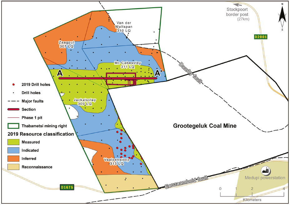
Table 33: Thabametsi project history
| Date range | Company | Material notes | ||
| 1979 - 1988 | Iscor - Iscor Mining | Exploration drilling began (7 boreholes drilled) | ||
| 1989 - 2006 | Kumba Resources | 51 Boreholes drilled | ||
| 2007 - 2015 | Exxaro Resources | Prospecting right and exploration activities specifically on the project area (180 boreholes drilled) | ||
| 2016 - current | Exxaro Resources | Mining right registered in 2016 is valid for 30 years (11 boreholes drilled) |
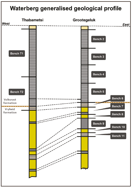
The geology is similar to Grootegeluk's geology but increased weathering and deteriorating coal qualities required a different bench configuration. In the north, the full succession of the Volksrust and Vryheid formations is present. However, further south, the Volksrust formation thins out and eventually disappears. A pertinent channel sandstone in the northern portion of the project area affects benches 9A and 9B. A cross-section through the geological model is presented in Figure 19.
Figure 18: Generalised profile of the Grootegeluk and Thabametsi geological profile
Logging and sampling follow the same protocols as at Grootegeluk mine. Controls in the work procedure ensure that mistakes are omitted from the process, initially from the placement of borehole survey data in the field to the point of delivery of samples to the laboratory, and after that from receiving analyses back from the laboratory to the point where data is used for geological modelling. These procedures include controls to ensure the drill core is correctly correlated, sampled, relative densities determined, and material recoveries validated to stipulated standards.
Prior to dispatching, coal and shale samples are reweighed in air to check that they have been correctly labelled and that the initial weights recorded are correct for subsequent relative density (RD) calculation. When samples arrive at the Bureau Veritas laboratory in Pretoria, they are reweighed and checked against the recorded RDs on the sample list supplied with the samples by the geology department. The geology personnel are notified of any discrepancy, which is rectified without delay.
The senior geologist in the geodata subsection at Grootegeluk mine is responsible for maintaining a system to ensure that all exploration borehole data is verified, and all geological information is correctly entered into the borehole database (Sable Data Warehouse). The individual is also responsible for tracking borehole samples in the analytical process, accepting analytical data from Bureau Veritas, electronic transfer of analytical data to the borehole database and validation of the data.
Resource estimation and data-compositing methods are aligned with the methodology applied at Grootegeluk. In recent years, five geological models have been built for the Thabametsi project area, accounting for alternate interpretations and compositing scenarios.
The Resource classification methodology throughout the Volksrust and Vryheid formations, although fundamentally based on SANS 10320 (guidelines for multi-seam deposits), is based on a matrix approach that incorporates borehole spacing, type of boreholes and structural complexity in the Resource. The approach is recognised as more conservative than applying guidelines for thick interbedded-type deposits and was chosen to remain conservative during current studies. The classification methodology will be reviewed (as with Grootegeluk) in 2020. Some 116 boreholes were used for Resource estimation and all contain coal-washability data.
Table 34: Thabametsi Coal Resource reporting criteria
| Thickness cut-off (thickness and extraction height considerations) |
Quality cut-offs (adb) | Geological loss (%) | ||
| <0.5m | Ash content of >65% | 5% |
Table 35: Thabametsi Coal Resource estimation criteria
| Item | Description | |||||
| Database | Borehole database | Sable Data Warehouse | ||||
| Data datum | LO27 WGS 84 | |||||
| Number of boreholes used for Resource estimation | 116 | |||||
| Validation | Conducted using queries in Sable and Excel | |||||
| Data compositing and weighting | Sable Data Warehouse | |||||
| Model | Previous model date | 2014 | ||||
| Last model update | 2015 | |||||
| Geological modelling software | Geovia MinexTM | |||||
| Estimation technique | Growth algorithm | |||||
| Grid mesh size | 45m x 45m | |||||
| Scan distance | 1 000m | |||||
| Data boundary | 300m | |||||
| Model build limits | Limit of weathering | |||||
| Model outputs | Roof, floor and thickness grids generated for structure and coal washability quality grids |
|||||
| Changes to modelling process | None |
Figure 19: Cross-section through 2015 Thabametsi geological model
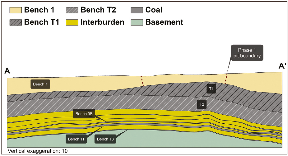
Table 36: Thabametsi Coal Resource classification criteria
| Resource category |
Type of boreholes | Borehole spacing (Volksrust Formation and Vryheid Formation) |
Structurally complex areas | ||||||
| Measured | Cored boreholes with applicable coal qualities | 0m – 350m | (Matrix) Additional geophysically logged boreholes needed | ||||||
| Indicated | Cored boreholes with applicable coal qualities | 350m – 500m | (Matrix) Additional geophysically logged boreholes needed | ||||||
| Inferred | Cored boreholes with applicable coal qualities | 500m – 1 000m | (Matrix) Additional geophysically logged boreholes needed |
Table 37: Thabametsi Resource and Reserve statement
| Category | 2019 (Mt) |
2018 (Mt) |
Difference in tonnes (Mt) |
Difference (%) |
||||
|---|---|---|---|---|---|---|---|---|
| Measured | 270 | 270 | ||||||
| Indicated | 749 | 749 | ||||||
| Inferred | 2 916 | 2 916 | ||||||
| Total Coal Resources | 3 935 | 3 935 | — | — | ||||
| Proved | 109 | 109 | ||||||
| Probable | 21 | 21 | ||||||
| Total Coal Reserves | 130 | 130 | — | — |
Rounding of figures may cause computational discrepancies.
Table 38: Thabametsi RPEEE considerations
| Item | Criteria | Considered | Comment | ||||||
| Geological data | Data has been validated and signed off by competent person | Yes | |||||||
| Geological model | Geological model was considered and signed off | Yes | Geological structure and depositional extent, seam thickness >0.5m and <65% ash | ||||||
| Structural model | Structure model was considered and signed off | Yes | |||||||
| Mining | Mining assumptions considered and defined | Yes | Opencast and underground | ||||||
| Assurance | Minimum tier 1 assurance (Exxaro governance) | Yes | 2015 | ||||||
| Economic evaluation | A concept-level exploitation with economic and mining assumptions, including geotechnical and geohydrological assumptions | Yes | Studies that underpin the IPP study and mining right mine works programme | ||||||
| Environmental | Reasonable demonstration that environmental approvals can be obtained within the context of local, regional and national governmental legislation | Yes | Approvals and land ownership in place | ||||||
| Tenure | Formal tenure must be demonstrated with reasonable demonstration that a mining right approval can be obtained within the context of local, regional and national governmental legislation | Yes | Mining right (30 years) | ||||||
| Infrastructure | Assumptions used should be reasonable and within known/assumed tolerances or have examples of precedence | Yes | Current infrastructure | ||||||
| Market | A potential market for the product with a reasonable assumption that this market is sustainable | Yes | IPP and current Grootegeluk steam coal market |
For the phase 1 feasibility study (IPCC Pit), XPAC mine-scheduling software is used to derive remaining saleable Reserves from RoM Reserves in the approved pit layout. After converting the geological model's grids to the appropriate format, the floor, roof and thickness data as well as the quality data for each bench is imported into the XPAC model. With this model, validations are performed to evaluate the data for possible mistakes, such as incremental yields for each bench rising with increases in relative float densities.
The Resource category areas are also loaded into the XPAC model for Reserve categorisation. Indicated Resources are generally converted to Probable Reserves and Measured Resources to Proved Reserves after consideration of all applicable modifying factors. If one or more of the modifying factors have not been fulfilled, Measured Resource is either not converted or the Measured Resource is converted but downgraded to Probable and the associated risk is clearly stated. Inferred Resources are not converted to Coal Reserves. No Inferred Resources are included in the LoM plan.
The Coal Reserve is based on a bankable feasibility project level of investigation.
Some assumptions regarding the highwall mining method need to be confirmed at the start of the operation.
The IPP financial close has been delayed by a number of regulatory and funding challenges. Exxaro is ensuring that all compliance actions are executed while strategic options are being considered.
Table 39: Thabametsi modifying factors considered in converting Coal Resources to Coal Reserves
| Modifying factors | Value | ||
| Geological loss | 5% | ||
| Average thickness cut-off | <1m | ||
| Quality cut-offs (adb) | Raw CV >11Mj/kg | ||
| Mining loss | *T1 - 0.5m losses to overburden *T2 - 0.25% of coal left in pit bottom |
||
| Boundary pillar | N/A | ||
| Dilution | Applied to in-situ mineable Reserves due to inter-layered composition of deposit | ||
| Contamination | T2 - 0.3m | ||
| Mining recovery efficiency | No additional losses due to proposed mining method. Coal transfer between benches T1 and T2 will balance out over time as both go to same plant | ||
| Planned average slope angles | 35 degrees | ||
| Practical plant yield | Crushing and screening process 98% | ||
| Strip ratio cut-off | Energy strip ratio >7Gj/ex-pit tonnes Strip ratio < 0.3m3/tonne |
||
| Environmentally sensitive areas | No sensitive areas in pit layout | ||
| Legal | The layout is within the mining right boundary | ||
| Social | There are no socially sensitive areas in the pit layout (for example graveyards and dwellings) | ||
| Geohydrological | No areas identified in the mining area |
* T1 and T2 are mining benches (Figure 19).