


| Mining commenced | 1980 |
|---|---|
| Type of mining | Opencast |
| Market | Domestic and export markets |
| Beneficiation | Four DMS beneficiation plants and two crushing and screening plants |
| Products | Various sized metallurgical coal products at 15% ash and 11.25% ash, semi-soft coking coal at 10.3% ash, as well as thermal coal at 33.2% ash |
| Year-on-year RoM | ↓ 1% logistics constraints and reduced sales demand |
| Year-on-year product | ↓ 7% reduced sales demand and fines handling |
| Exploration | 41 drill holes were completed during the year |
| Year-on-year Resources | ↓ 1% mainly as a result of depletion |
| Year-on-year Reserves | ↓ 2% mainly as a result of depletion |
| Remaining LoM | 18+ years (constraint by current tenure period) |
| Opportunities/operational excellence | Short-term modelling targeted at improving estimation and recoveries on bottom benches |
Grootegeluk is a mature mine that has been operating since 1980. Despite the poor performance from TFR and reduced sales compared to budget, Grootegeluk had good cost management and profit margins. With Medupi Unit 4 coming back online in Q4 2024, there are good prospects on increased coal offtake for 2024 onwards. PwC conducted an audit on the internal Resource and Reserve estimation process at Grootegeluk in 2023 with no major findings and one minor level 3 finding. The finding was addressed in the 2023 annual Resource and Reserve report. As mining progresses westwards, there is an increase in the complexity of geological structures and mitigation measures have been adopted to focus on geotechnical and geological controls. Grootegeluk is continuously seeking ways to improve extraction of Coal Reserves.
Table 40: Grootegeluk overview
| Topic | Information | ||
| Location | 25km west of the town of Lephalale in Limpopo, South Africa | ||
| History | Previous ownership | Material notes | |
| 1976 to 1990 | Yskor – Iscor – Iscor mining – Kumba | Exploration drilling (~200 drill holes) | |
| 1990 to 2006 | Kumba – Kumba coal – Exxaro Resources | Mine commissioned in 1980. Mine in operation for approximately 43 years. Continuous exploration drilling to increase Resource confidence and aid structural delineation and OVB classification (~1 480 drill holes). |
|
| 2006 to 2022 | Exxaro Resources | Pit layout shifted in 2021 according to the latest wings exploitation strategy. GG 6 plant commissioned in 2022. Ninety exploration drill holes completed. | |
| 2023 | Exxaro Resources | Optimisation initiatives | |
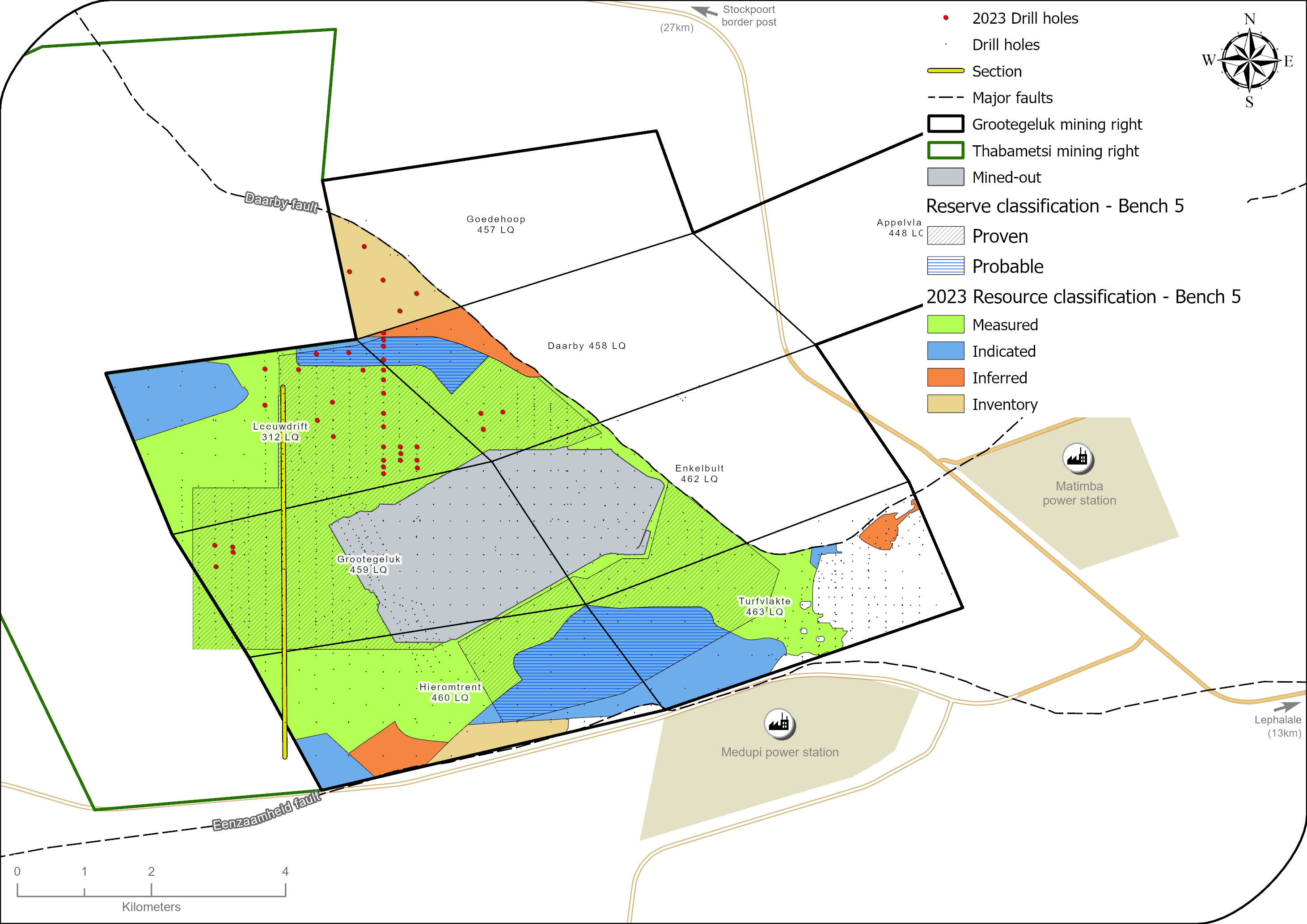
| Adjacent properties | The Thabametsi project, an Exxaro mining right, adjacent to the western boundary of the operation. | ||
| Infrastructure | Grootegeluk can be reached from Lephalale via the hard-topped Nelson Mandela Drive which is linked to the R510 road connecting Lephalale to the town of Vaalwater to the south and the Stockpoort border post between South Africa and Botswana to the north. Power supply to the mine is obtained directly from Matimba power station via two 132kV lines that supply the mine’s three 840MVA transformers. Raw water is delivered to the mine and to a water treatment plant on the farm in Zeeland by the 700mm diameter Hans Strijdom pipeline. The pipeline originates at the Mokolo Dam. Potable water from the Zeeland water treatment plant is in turn routed to the mine and local communities. | ||
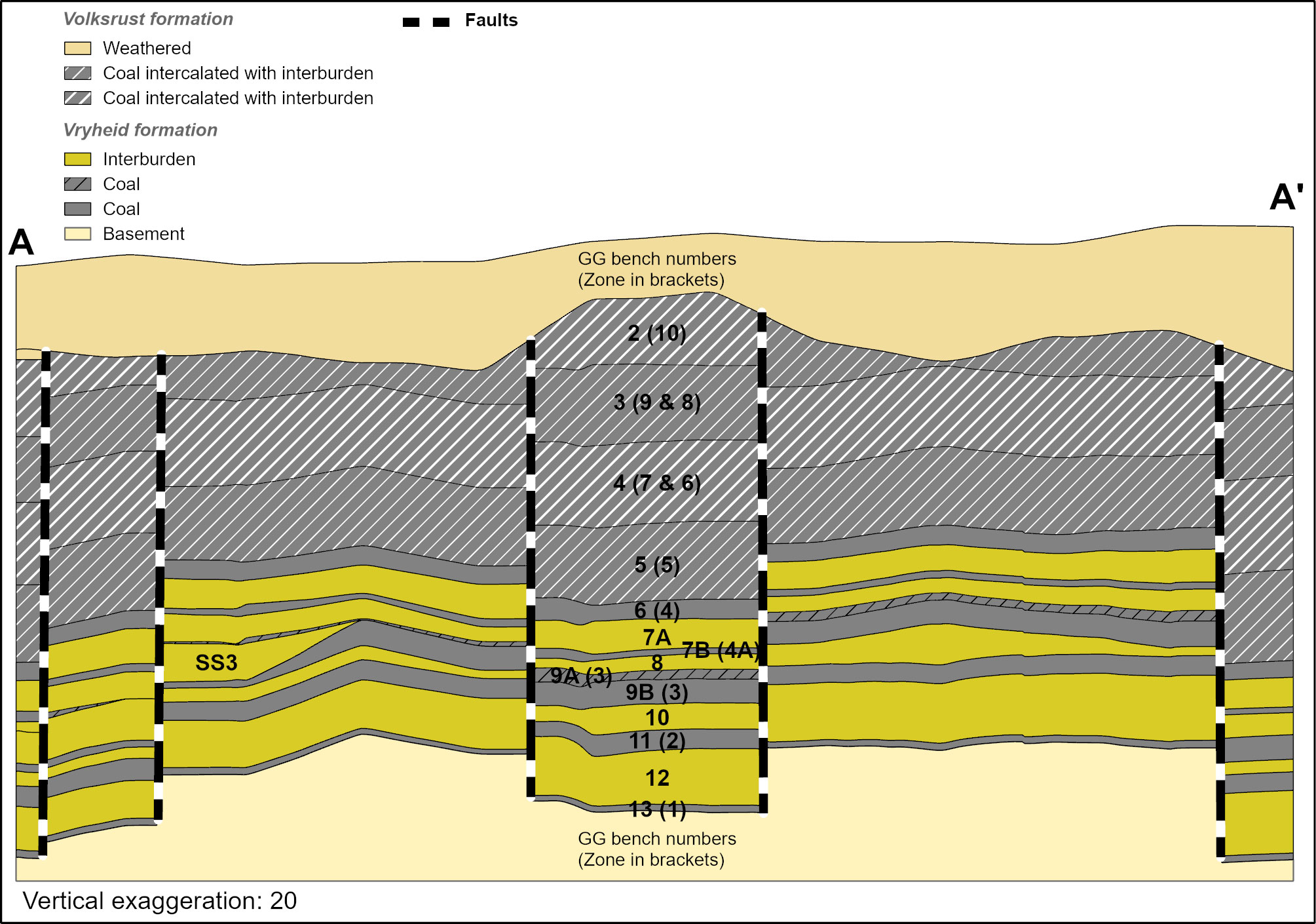
| Coalfield | Grootegeluk is located in the Waterberg coalfield and the coal seams are from the Volksrust and Vryheid formations. | ||
| Main seams | The upper part of the coal deposit, the Volksrust Formation (approximately 60m thick) is classified as a thick interbedded seam deposit type, comprising intercalated mudstone or carbonaceous shale and bright coal layers. The Vryheid Formation (approximately 55m thick) forms the lower part of the coal deposit and comprises carbonaceous shale and sandstone with interbedded dull coal seams varying in thickness from 1.5m to 9m. It is therefore classified as a multiple-seam deposit type. | ||
| Seam development | These coal seams are subdivided into 11 coal zones, further divided into separate coal and non-coal samples for analysis. A total of 77 samples are analysed per full succession drill hole. The Volksrust Formation consists of 30 coal samples and 30 non-coal samples whereas the Vryheid Formation consists of 13 coal samples and four non-coal samples. | ||
| Depositional control | The Zoetfontein fault forms the boundary of the Waterberg coalfield in the north and the Eenzaamheid fault forms the boundary in the south. The Daarby fault, with a throw of some 350m, divides the coalfield into a deep north-eastern portion and a shallow south-western portion. On average, the first fresh coal in the shallow south-western portion is 20m below surface. The lowermost coal seam (Zone 1) occurs at a depth of about 130m in the shallow portion of the coalfield, but this may vary depending on the local structure. The predominantly horizontal coal-bearing formations have a very gentle dip to the south-east near Grootegeluk. Only a few dolerite dykes outcrop in the south-eastern portion of the Waterberg coalfield, and no sills have been encountered in any exploration drill holes drilled in the mining right area to date. | ||
| Resources and Reserves | The Resource extent is restricted by the depositional controls discussed above. The Reserves are restricted within the Resource blocks. The reporting of LoM is limited to the lapse of the mining right, although Coal Reserves exist well beyond this date. A small area of Coal Resources is located within the adjacent Thabametsi mining right included in the Grootegeluk LoM (Figure 14) due to practical pit design considerations. Exxaro owns both rights. | ||
| Mining method | Grootegeluk comprises one open-pit mine with three OVB benches, 10 RoM benches and four interburden benches. A series of parallel benches is advanced progressively across the deposit via drilling, blasting, loading and hauling with truck-and-shovel fleets. RoM is transported to the Grootegeluk beneficiation complex via haul trucks and in-pit crushing and conveying systems. | ||
| Beneficiation | Grootegeluk uses six processing plants to beneficiate coal. This includes four DMS beneficiation plants and two crushing and screening plants. | ||
| Product | Various sized metallurgical coal products at 15% ash and 11.25% ash, semi-soft coking coal at 10.3% ash and thermal coal at 33.2% ash are railed to various customers and shipped to international customers via an export harbour. A small portion of the total product is sold on site to smaller customers and dispatched by road. | ||
| Market | Domestic and export markets. | ||
| Mining right | Grootegeluk has an approved mining right that covers some 8 703.35ha. | ||
| Environmental approvals | All environmental appeals have been favourably addressed for the declared Reserves. | ||
| Projects/feasibility studies | There are no feasibility studies directly linked to Resources and Reserves or changes in the LoMP that are currently underway. There are, however, projects on the relocation of the in-pit crusher and a study on the efficient and effective management of the Grootegeluk trucks and shovels. Grootegeluk mine is a mature operation that is currently in steady-state production. The current installed capacity is sufficient to satisfy current and foreseeable demand. Despite this, optimising the use of the installed capacity is a continuous process that is assessed and adjusted as required. | ||
Table 41: Resource estimation methodology and reporting
| Process | Information | ||
| Drilling, logging and sampling | To have sufficient material available from each sample for the required suite of analyses to relative densities of 2.20g/m3 , large diameter: 123mm diameter rotary core drill holes. The large diameter drill holes are drilled in between the existing 500m x 500m grid of small diameter drill holes. This placement of large diameter drill holes was so the analysis of samples from the large diameter drill holes could be used to supplement the analysis of existing small diameter drill holes where samples and density fractions were absent. Sampling of drill holes is only conducted after the stratigraphy has been correlated. The geologist in charge supervises all drill hole drilling and is responsible for logging and sampling. |
||
| Laboratory and accreditation | Bureau Veritas, SANAS T0469. | ||
| Laboratory dispatch and receiving process | Each sample submitted to the laboratory is accompanied by a unique sample number for validation and tracking, as well as a submission list that serves as a sample advice sheet with instructions for analysis. | ||
| Laboratory QAQC | Audits are performed internally and externally as part of the QAQC. Bureau Veritas is accredited for analytical work and participates in monthly local and international round robins. | ||
| Data datum | WGS84 – LO27 | ||
| Drill hole database | acQuire | ||
| Number of drill holes in mining right | 1 617 (including Thabametsi mining right area) | ||
| Number of drill holes used for Resource estimation | 1 341 | ||
| Number of drill holes used for classification 388 | 581 | ||
| Data compositing and weighting | Data compositing is conducted per seam using a weighted value from individual samples that make up the seam, along with each sample's relative density and length. This is conducted in acQuire. | ||
| Data validation | Conducted using queries in acQuire, Minex™ and Excel | ||
| Geological modelling software | GEOVIA Minex™ | ||
| Estimation technique | Growth algorithm | ||
| Previous model date | 2020 | ||
| Last model update | 2022 | ||
| Grid mesh size | 20m x 20m | ||
| Scan distance | 1 000m | ||
| Data boundary | 100m | ||
| Model build limits | Upper: limit of weathering and topography/collar |
||
| Model outputs | Roof, floor and thickness grids generated for structure Raw and wash quality grids |
||
| Changes to modelling process | None | ||
| Thickness cut-off and extraction height considerations | Opencast ≤0.5m | ||
| Quality cut-offs (adb) | ≥65% ash Volksrust Formation coal, ≥50% ash Vryheid Formation coal | ||
| Geological loss applied | Variable per bench, calculated each year considering geological model estimation error and physical geological loss. 0.5 to 0.75% for Proved Reserves, 1 to 1.5% for Probable Reserves |
||
Table 42: Resource classification criteria
| Category | Type of drill holes | Drill hole spacing | Structurally complex areas | Drill holes/ha | ||||
| Measured | Cored drill holes with applicable coal qualities | 0m to 500m | (Matrix) Additional geophysically logged drill holes needed | 0.10 | ||||
| Indicated | Cored drill holes with applicable coal qualities | 500m to 1 000m | (Matrix) Additional geophysically logged drill holes needed | 0.05 | ||||
| Inferred | Cored drill holes with applicable coal qualities | 1 000m to 3 000m | (Matrix) Additional geophysically logged drill holes needed | 0.02 |
Table 43: RPEEE considerations
| Item | Criteria | Criteria met | Comment | |||
| Geological data | Data has been validated and signed off by Competent Person. | Yes | Geological structures, seam thickness ≤0.5m, ash content ≥65% ash Volksrust Formation coal and ≥50% ash Vryheid Formation coal. Coal qualities reported on an adb. | |||
| Geological model | Geological model has been considered and signed off. | Yes | 2022 | |||
| Structural model | Structural model was considered and signed off. | Yes | 2022 | |||
| Mining | Mining assumptions were considered and defined. | Yes | Opencast | |||
| Assurance | Exxaro internal audits and an external audit were conducted. | Yes | Internal review on Resource processes and LoM in 2022, external process audit by PwC in 2023. | |||
| Economic evaluation | Conducted an exploitation study with economic and mining assumptions, including geotechnical and geohydrological assumptions. | Yes | Exploitation strategy over mining right. | |||
| Environmental | Reasonable demonstration that environmental approvals can be obtained within the context of local, regional and national governmental legislation. | Yes | All applicable approvals are in place. | |||
| Tenure | Formal tenure must reasonably demonstrate that a mining right approval can be obtained within the context of local, regional and national governmental legislation. | Yes | Mining right with no impediments is valid until 2041 and there is a reasonable expectation that the right will be renewed. | |||
| Infrastructure | Assumptions used should be reasonable and within known or assumed tolerances or have examples of precedence. | Yes | Existing infrastructure is adequate and can be upgraded with new required infrastructure under construction. | |||
| Market | A potential market for the product with a reasonable assumption that this market is sustainable. | Yes | Current CSAs for domestic and export markets. |
Table 44: Reserve estimation
| Topic | Information | ||
| Software | OCCS | ||
| Reserving process | Production scenarios are defined by scrutinising different market demand scenarios for product sales and evaluating estimated future installed production capacity. Ultimately, care is taken to select the most probable scenario to be scheduled as the LoMP. Once the RoM and product schedule are completed, a process is followed whereby the OVB and interburden scheduling is altered to obtain a “smoothed” year-on-year ex-pit profile to prevent erratic mining equipment requirements. The pit shell is designed from an economic and product quality perspective to ensure the longevity of the Grootegeluk operation. |
||
| Conversion classification | Indicated Resources are generally converted to Probable Reserves and Measured Resources to Proved Reserves after consideration of all applicable modifying factors. If one or more of the modifying factors have not been fulfilled, Measured Resources are either not converted or the Measured Resources are converted but downgraded to Probable and the associated risk is clearly stated. Inferred Resources are not converted to Coal Reserves. | ||
| Inferred Resources inside LoM | Some 73Mt of Inferred Resources are included in the LoMP, representing 2.9% of the LoMP, and are not considered material. The impact of the Inferred Resources is known with the majority occurring at the tail end of the LoMP and addressed by an integrated exploration plan that is reviewed every year. | ||
Modifying factors |
|||
| Average thickness cut-off | ≤0.5m | ||
| Quality cut-offs | ≥65% ash content (raw in situ) | ||
| Mining loss | No loss applied as all mining boundaries are reached, and no pillars are left. | ||
| Boundary pillar | N/A | ||
| Dilution | Applied to in situ mineable Reserves due to the inter-layered composition of the deposit. | ||
| Contamination | Varies per bench: 0 to 0.75m applied to interburden seams. | ||
| Mining recovery efficiency | Varies per bench: 0 to 0.75m depending on bench height. | ||
| Planned average slope angles | <61.7 degrees | ||
| Practical plant yield | Considered in the reserving process as per wash table information per combination of blocks per planning increment and the empirically determined practical yield adjustment factor. | ||
| Strip ratio cut-off | Energy strip ratio >7GJ/ex-pit tonne. Kept at an average of 0.74 for the next five years as per FC9+3 2023. | ||
| Environmentally sensitive areas | Areas underlying wetlands and other eco-sensitive areas are excluded from the Reserves, distance as per environmental requirements. | ||
| Legal | The layout is within the mining right boundary and not closer than 15m. | ||
| Social | The pit layout has no known socially sensitive areas (for example, graveyards and dwellings). | ||
| Geohydrological | Areas identified are flagged and excluded or reclassified in the reserving process. | ||
Table 45: Grootegeluk Coal Resources and Coal Reserves statement
| Category | 2023 (Mt) | 2022 (Mt) | Difference in tonnes (Mt) | Difference (%) | Reason for change | |||||
| Measured | 2 978 | 3 039 | (60) | (2) | Decrease is due to depletion (59Mt), disposal of bench 7B and bench 13 (1Mt) and sterilisation (2Mt). This was slightly offset by reconciliation (2Mt). | |||||
| Indicated | 967 | 967 | ||||||||
| Inferred | 178 | 178 | ||||||||
| Total Coal Resources | 4 123 | 4 184 | (60) | (2) | ||||||
| Proved | 1 971 | 2 034 | (63) | Depletion (58Mt) and mining recovery efficiency (6Mt), including weathering, undermining, faulting and Probable 550 550 construction of in-pit ramps, resulted in the decrease. | ||||||
| Probable | 550 | 550 | ||||||||
| Total Coal Reserves | 2 521 | 2 584 | (63) | (2) |
| • | Rounding of figures may cause computational discrepancies. |
| • | Tonnages quoted in metric tonnes and million tonnes (Mt). Coal Resources quoted as MTIS. |
Table 46 outlines the exploration for the reporting year. For detailed expenditure, please refer to Table 64.
Table 46: Exploration summary
| Objectives | Progress in reporting year | Plans for next reporting year | ||
| Geological and geotechnical OVB material characterisation, geotechnical characterisation of the coal benches, delineation of structures and resource classification | 28 percussion holes drilled for OVB material classification and to aid fault delineation in structurally complex areas. Three rotary core triple tube drill holes drilled for geotechnical characterisation of the coal benches. 10 deep rotary core drill holes drilled to obtain samples for quality analysis and to aid in Resource classification. |
Eight rotary core drill holes for Resource estimation and classification. 23 percussion drill holes for OVB classification and structural delineation. Three rotary core drill holes for geotechnical characterisation of the coal benches. |
Table 47: Grootegeluk risks
| Risk | Description | Mitigation | ||
| Economic | In recent years, logistical constraints caused by a shortage in the supply of trains from TFR have hampered the delivery of higher-value products from the mine. In addition, like any commodity, coal is subject to price fluctuation, which can have varying impacts on profitability. | The mine’s primary product is power station coal, for which longterm supply agreements are in place with Eskom. Exxaro constantly monitors prevailing market conditions to ensure an optimal product mix that will ensure sustainability. Logistical challenges are addressed as a continuous effort to ensure product to market are realised. | ||
| Backfill construction material availability | Backfill infrastructure construction material availability (blue shale), which is due to increased OVB weathering as mining progresses west, poses a risk to both the efficiency and integrity of advancing pit infrastructure which is critical for GGC pit dynamics. | Bench 12 material mined during the construction of sumps is used to manage this risk. This will be the case for the sumps to be constructed in the next five years. Bench 10 material is also available for this purpose in areas where mining without contamination is practical. A borrow pit in the north pit is also included in the LoMP should the two mentioned mitigations not be sufficient to manage the risk. | ||
| Increase in sulphur content | Increase in the sulphur content of benches used to produce semi-soft coking coal (SSCC) and on the benches used for dry crush and screen power station coal production. | Blending the SSCC-producing benches and dry crush and screen benches is still the best solution for this risk. GG7 plant has the capacity to wash the coarse fraction where pyritic sulphur deports. | ||
| Faulting | The structure interpretation (fault position) in the geological model is based on drill hole information that is widespread in the Inferred category. | Additional percussion boreholes are drilled in structurally complex areas after they are covered by the normal cored exploration drill hole grid to finalise the position and characteristics of the faults, by geophysical logging of the drill holes. These additional drill holes assist in better understanding the potential impacts of the structures on operations to derive mitigating exploitation strategies. |
Other than the risks listed above, there are no known environmental, social, political and governance risks that could potentially impact the exploitation of the Coal Reserves.
Operational excellence initiatives focused on improving estimation confidence on the bottom benches to improve on coal recoveries. The initiatives included differential loss factor domaining, where different loss factors were applied to different mining areas within a bench. Using pre-split drill holes for in-pit Resource classification as an additional grade control tool was adopted to increase estimation confidence and subsequently led to high-precision loading. Grootegeluk continuously strives to improve efficiencies and optimise the available Coal Resources and Coal Reserves.
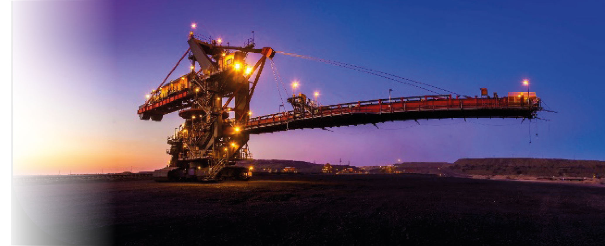
Stacker for discard backfill at Grootegeluk