


| Mining commenced | Project phase |
|---|---|
| Type of mining | Opencast |
| Market | Domestic |
| Beneficiation | No beneficiation |
| Products | Power station coal for an on-site IPP as part of phase 1 |
| Year-on-year RoM | N/A |
| Year-on-year product | N/A |
| Exploration | No exploration conducted in 2023 |
| Year-on-year Resources | No change |
| Year-on-year Reserves | No change |
| Remaining LoM | 23 years |
| Opportunities/operational excellence | Grootegeluk is considering scenarios as to extract maximum value through an integrated approach for the Waterberg business. |
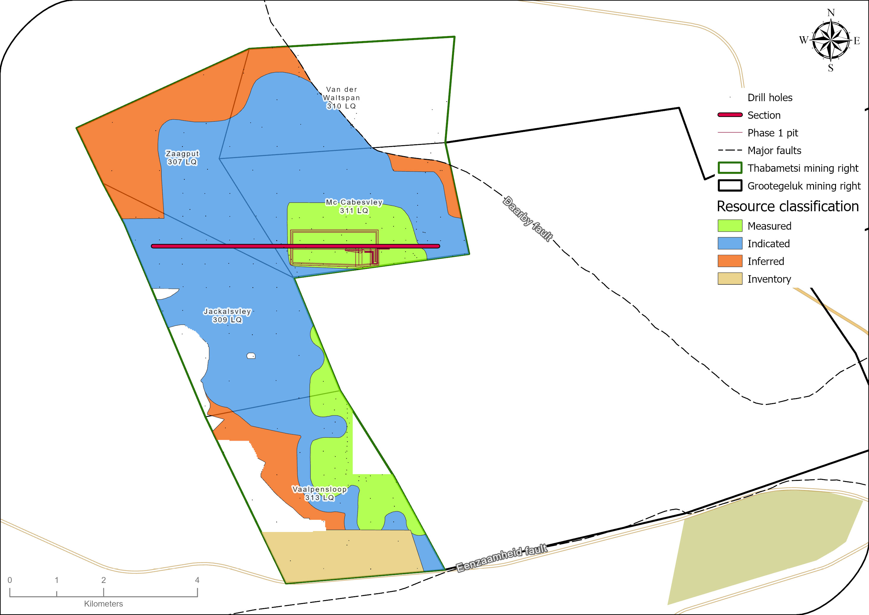
Thabametsi is divided into a northern opencast portion and a southern underground portion. The northern opencast portion aims to produce power station coal for an on-site IPP, and the southern underground portion is earmarked for beneficiated high-value products. As outlined last year, we evaluated the potential of the Thabametsi mining right, a large Coal Resource next to the Grootegeluk coal mine, after the associated IPP project was cancelled. Exxaro has compiled a consolidation plan which will be submitted for approval at the applicable authorities.
Table 48: Thabametsi overview
| Topic | Information | ||
| Location | 22km west of the town of Lephalale in Limpopo, South Africa | ||
| History | Previous ownership | Material notes | |
| 1976 to 1988 | Iscor – Iscor mining | Exploration drilling | |
| 1989 to 2006 | Kumba | Exploration drilling | |
| 2007 to 2015 | Exxaro Resources | Prospecting right and exploration activities | |
| 2016 to present | Exxaro Resources | Mining right registered in 2016, valid until 2046 | |
| Adjacent properties | Grootegeluk mine to the east | ||
| Infrastructure | Thabametsi is adjacent to Grootegeluk and therefore uses the same infrastructure. It can be reached from Lephalale via the hard-topped Nelson Mandela Drive, which is linked to the R510 road connecting Lephalale to the town of Vaalwater to the south and the Stockpoort border post between South Africa and Botswana to the north. Power supply to Grootegeluk is obtained directly from the power station via two 132kV lines. Raw water is delivered to the mine and to a water treatment plant on the farm in Zeeland by the 700mm diameter Hans Strijdom pipeline. The pipeline originates at the Mokolo Dam in the Waterberg Mountain. | ||
| Coalfield | Waterberg coalfield | ||
| Main seams | The upper part of the coal deposit, the Volksrust Formation (approximately 60m thick), is classified as a thick interbedded seam deposit type, comprising intercalated mudstone or carbonaceous shale and bright coal layers. The Vryheid Formation (approximately 55m thick) forms the lower part of the coal deposit and comprises carbonaceous shale and sandstone with interbedded dull coal seams varying in thickness from 1.5m to 9m. It is therefore classified as a multiple-seam deposit type. | ||
| Seam development | The geology is similar to Grootegeluk’s, but practical mining practice required a different bench configuration. In the north, the full succession of the Volksrust and Vryheid formations are present. However, further south, the Volksrust Formation thins out and eventually disappears. A pertinent channel sandstone in the northern portion of the project area affects benches 9A and 9B. | ||
| Depositional control | The Zoetfontein fault forms the boundary of the Waterberg coalfield in the north while the Eenzaamheid fault forms the boundary in the south. The Daarby fault, with a throw of some 350m, divides the coalfield into a deep north-eastern portion and a shallow south-western portion. On average, the first fresh coal in the shallow south-western portion is 20m below surface. The lowermost coal seam (Zone 1) occurs at a depth of about 130m in the shallow portion of the coalfield, but this may vary depending on the local structure. The predominantly horizontal coal-bearing formations have a very gentle dip to the south-east near Grootegeluk. Only a few dolerite dykes outcrop in the south-eastern portion of the Waterberg coalfield, and no sills have been encountered in any exploration drill holes drilled in the mining right area to date. | ||
| Resources and Reserves | The Resource extent is restricted by the depositional controls discussed above. The Reserves are restricted within the Resource blocks. | ||
| Mining method | The project area is divided into a northern opencast portion and a southern underground area. | ||
| Beneficiation | N/A | ||
| Product | The northern portion aims to produce power station coal for an on-site IPP as part of phase 1. | ||
| Market | Domestic | ||
| Mining right | Thabametsi has an approved mining right that covers some 5 455ha. | ||
| Environmental approvals | All environmental appeals have been favourably addressed for the declared Reserves. | ||
| Projects/feasibility studies | A feasibility study on phase 1 was successfully concluded in 2016, and studies on extending the phase and the southern project area are ongoing. In October 2016, the South African Minister of Mineral Resources and Energy announced that the Thabametsi power project, for which the Thabametsi project has a 30-year CSA, had been selected as a preferred bidder in the first bid window of South Africa’s coal-baseload IPP procurement programme. The subsequent process to realise this initiative has progressed over the last few years. The project development agreement with our IPP project partner lapsed during the previous reporting year, and we subsequently changed our reporting of Proved Reserves to the Probable category to address this uncertainty. Exxaro is currently ensuring that all compliance actions are executed. | ||
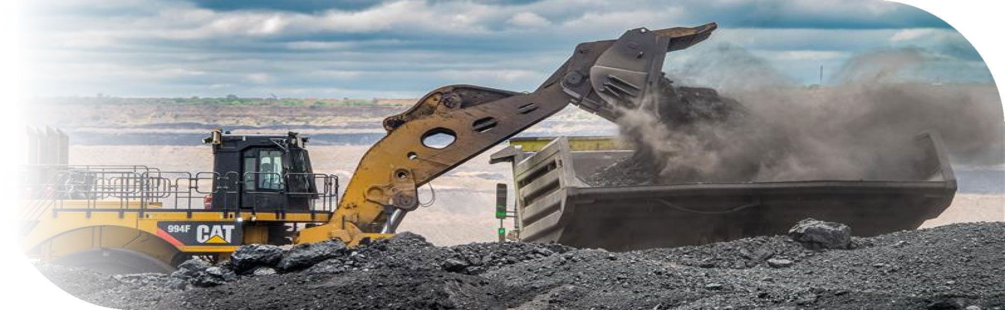
Loading coal at Grootegeluk
Table 49: Resource estimation methodology and reporting
| Process | Information | ||
| Drilling, logging and sampling | Logging and sampling follow the same protocols as at Grootegeluk mine. | ||
| Laboratory and accreditation | Bureau Veritas, SANAS T0469. | ||
| Laboratory dispatch and receiving process | Sampling of drill holes is only conducted after the stratigraphy has been correlated. The geologist in charge supervises all drill hole drilling and is responsible for logging and sampling. Each sample submitted to the laboratory is accompanied by a unique sample number for validation and tracking, and a submission list that serves as a sample advice sheet with instructions for analysis. | ||
| Laboratory QAQC | The laboratory follows one of four standard suites of analysis for each sample from Grootegeluk, namely Volksrust Formation coal, Volksrust Formation shale, Vryheid Formation coal and Vryheid Formation shale. Emphasis is placed on ensuring data integrity through rigorous procedures and supervision while processing. Audits are performed internally and externally as part of the assurance and control process. Bureau Veritas is accredited for analytical work and participates in monthly local and international round robins. | ||
| Data datum | WGS84 – LO27 | ||
| Drill hole database | acQuire | ||
| Number of drill holes in mining right | 218 | ||
| Number of drill holes used for Resource estimation | 116 | ||
| Number of drill holes used for classification 388 | 116 | ||
| Data compositing and weighting | Coal analysis and beneficiation module in Sable Data Works Proprietary Limited | ||
| Data validation | Conducted using queries in acQuire, Minex™ and Excel | ||
| Geological modelling software | GEOVIA Minex™ | ||
| Estimation technique | Growth algorithm | ||
| Previous model date | 2014 | ||
| Last model update | 2015 | ||
| Grid mesh size | 45m x 45m | ||
| Scan distance | 1 000m | ||
| Data boundary | 300m | ||
| Model build limits | Upper: limit of weathering and topography/collar Lower: Zone 1 floor |
||
| Model outputs | Roof, floor and thickness grids generated for structure Raw and wash quality grids |
||
| Changes to modelling process | None | ||
| Thickness cut-off and extraction height considerations | Opencast ≤0.5m | ||
| Quality cut-offs (adb) | Ash ≥65% | ||
| Geological loss applied | Variable per bench based on the adjacent Grootegeluk methodology | ||
Table 50: Resource classification criteria
| Category | Type of drill holes | Drill hole spacing | Structurally complex areas | Drill holes/ha | ||||
| Measured | Cored drill holes with applicable coal qualities | 0m to 350m | (Matrix) Additional geophysically logged drill holes needed | 0.08 | ||||
| Indicated | Cored drill holes with applicable coal qualities | 350m to 500m | (Matrix) Additional geophysically logged drill holes needed | 0.04 | ||||
| Inferred | Cored drill holes with applicable coal qualities | 500m to 1 000m | (Matrix) Additional geophysically logged drill holes needed | 0.01 |
Table 51: RPEEE considerations
| Item | Criteria | Criteria met | Comment | |||
| Geological data | Data has been validated and signed off by Competent Person. | Yes | Geological structures, seam thickness ≤0.5m, ash content ≥65%. Coal qualities reported on an adb. | |||
| Geological model | Geological model has been considered and signed off. | Yes | 2015 | |||
| Structural model | l Structural model was considered and signed off. | Yes | 2015 | |||
| Mining | Mining assumptions were considered and defined. | Yes | Opencast and underground. | |||
| Assurance | Exxaro internal audits and an external audit were conducted. | Yes | 2015 | |||
| Economic evaluation | Exploitation study with economic and mining assumptions, including geotechnical and geohydrological assumptions. | Yes | Studies that underpin the IPP study and mining right mine works programme. | |||
| Environmental | Reasonable demonstration that environmental approvals can be obtained within the context of local, regional and national governmental legislation. | Yes | All environmental approvals and land ownership in place. | |||
| Tenure | Formal tenure must reasonably demonstrate that a mining right approval can be obtained within the context of local, regional and national governmental legislation. | Yes | Mining right expires in 2046 with no impediments noted. A proposal was submitted to the applicable authorities regarding a revised mine works programme. | |||
| Infrastructure | Assumptions used should be reasonable and within known or assumed tolerances or have examples of precedence. | Yes | Current infrastructure. | |||
| Market | A potential market for the product with a reasonable assumption that this market is sustainable. | Yes | IPP and current Grootegeluk steam coal market. |
Table 52: Reserve estimation
| Topic | Information | ||
| Software | XPAC | ||
| Reserving process | For phase 1 of the IPP feasibility study, XPAC mine scheduling software is used to derive remaining saleable Reserves from RoM Reserves in the approved pit layout. After converting the geological model’s grids to the appropriate format, the floor, roof and thickness data and the quality data for each bench are imported into the XPAC model. With this model, validations are performed to evaluate the data for possible mistakes such as incremental yields for each bench rising with increases in relative float densities. |
||
| Conversion classification | Indicated Resources are generally converted to Probable Reserves and Measured Resources to Proved Reserves after consideration of all applicable modifying factors. If one or more of the modifying factors have not been fulfilled, Measured Resources are either not converted or are converted but downgraded to Probable and the associated risk is clearly stated. Inferred Resources are not converted to Coal Reserves. The Coal Reserves are based on a bankable feasibility project level of investigation. The project development agreement with our IPP project partner lapsed during the previous reporting year and we subsequently changed our reporting of Proved Reserves to the Probable category to address this uncertainty. Exxaro is currently ensuring that all compliance actions are executed. |
||
| Inferred Resources inside LoM | N/A | ||
Modifying factors |
|||
| Average thickness cut-off | ≤1m | ||
| Quality cut-offs | Raw CV ≤11Mj/kg | ||
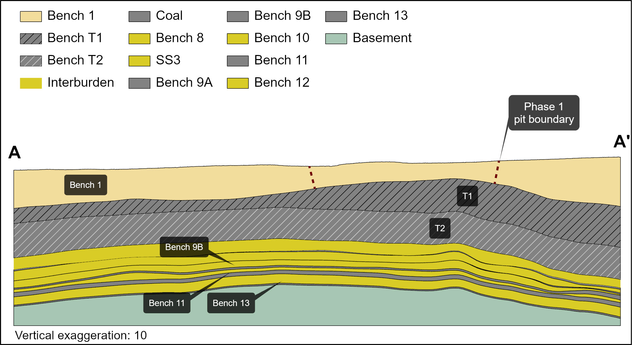
| Mining loss | *T1 – 0.5m losses to OVB *T2 – 0.25% of coal left in pit bottom |
||
| Boundary pillar | N/A | ||
| Dilution | Applied to in situ mineable Reserves due to inter-layered composition of deposit. | ||
| Contamination | T2 – 0.3m | ||
| Mining recovery efficiency | No additional losses due to proposed mining method. Coal transfer between benches T1 and T2 will balance out over time as both go to the same plant. | ||
| Planned average slope angles | 35 degrees | ||
| Practical plant yield | Crushing and screening process 98% | ||
| Strip ratio cut-off | Energy strip ratio >7Gj/ex-pit tonnes Strip ratio <0.3m3/t | ||
| Environmentally sensitive areas | No sensitive areas in the pit layout. | ||
| Legal | The layout is within the mining right boundary. | ||
| Social | The pit layout has no known socially sensitive areas (for example, graveyards and dwellings). | ||
| Geohydrological | No areas identified in the mining area. | ||
| * | T1 and T2 mining benches (Figure 17). |
Table 53: Thabametsi Coal Resources and Coal Reserves statement
| Category | 2023 (Mt) | 2022 (Mt) | Difference in tonnes (Mt) | Difference (%) | Reason for change | |||||
| Measured | 270 | 270 | No change | |||||||
| Indicated | 749 | 749 | ||||||||
| Inferred | 2 857 | 2 857 | ||||||||
| Total Coal Resources | 3 876 | 3 876 | ||||||||
| Proved | ||||||||||
| Probable | 130 | 130 | ||||||||
| Total Coal Reserves | 130 | 130 |
| • | Rounding of figures may cause computational discrepancies |
| • | Tonnages quoted in metric tonnes and million tonnes (Mt). Coal Resources quoted as MTIS. |
Table 54 outlines the exploration for the reporting year. For detailed expenditure, please refer to Table 64.
Table 54: Exploration summary
| Objectives | Progress in reporting year | Plans for next reporting year | ||
No drilling. |
Desktop studies to further optimise extraction alternatives. |
Table 55: Thabametsi risks
| Risk | Description | Mitigation | ||
| Market | The project development agreement with our IPP project partner lapsed. | Exxaro concluded the evaluation of the potential of the Thabametsi mining right. We compiled a consolidation plan which will be submitted to the applicable authorities for approval. We have a reasonable expectation that the consolidation plan will be accepted and implemented. |
Other than the risks listed above, there are no known environmental, social, political and governance risks that could potentially impact the exploitation of the Coal Reserves.
Grootegeluk is considering scenarios to extract maximum value through an integrated approach for the Waterberg business.