


| Mining commenced | 1992 |
|---|---|
| Type of mining | Opencast |
| Market | Export and domestic market |
| Beneficiation | Two DMS plants and two C&S and bypass plants |
| Products | 4 200kcal/kg, 4 800kcal/kg and 5 300kcal/kg, peas and duff net as received |
| Year-on-year RoM | ↑ 30% related to increased OVB removal. However, this is 13% below budget |
| Year-on-year product | ↑ 23% related to increased OVB removal. However, this is 18% below budget |
| Exploration | No exploration conducted in 2023 due to a delayed contractor procurement process |
| Year-on-year Resources | ↓ 9% mainly as a result of depletion, mining loss and sterilisation |
| Year-on-year Reserves | ↓ 14% mainly as a result of depletion, sterilisation and model refinement |
| Remaining LoM | Six years |
| Opportunities/operational excellence | UB pit evaluation scheduled for 2024. Activitybased planning model to be conducted in 2024 |
Leeuwpan strives to operate safely and reached 33 years fatality free. In 2023, production focused in OI west and OL eastern Reserves due to lower stripping ratios. Despite multiple optimisation initiatives, production RoM, product and sales were below budget due to pit liberation challenges.
Some of the challenges experienced were higher OVB stripping ratios than budgeted, material re-handling, poor compliance to plan, poor sales, and low inventory for the plants.
Table 24: Leeuwpan overview
| Topic | Information | ||
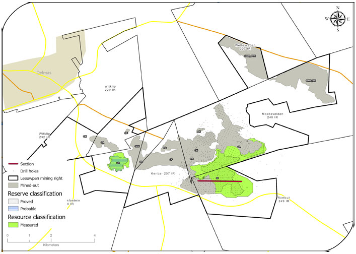
| Location | 10km south-east of the town of Delmas in Mpumalanga, South Africa. | ||
| History | Previous ownership | Material notes | |
| 1988 to 2006 | Iscor – Iscor mining – Kumba | Exploration began in 1990, the first box cut was commissioned in 1992 and rights were ceded to Exxaro in 2006. ~400 exploration drill holes drilled. | |
| 2006 to 2022 | Exxaro | Infill exploration drilling (~1 800 drill holes); the mine has been operating for approximately 32 years. OL has been operating since 2013, OI since 2018 and the western OI extension since 2020. | |
| 2023 | Exxaro | Depletion of OI west mining area. All areas were updated to Measured status. | |
| Adjacent properties | Stuart Colliery, Delta Mining Company and HCI Khusela Coal mines own property near Leeuwpan. Thaba Chueu Mine (silica mine) is adjacent to Leeuwpan. | ||
| Infrastructure | Leeuwpan lies alongside the R50 provincial road and is serviced by a railway line with a rapid load-out station inside Leeuwpan’s rail loop. Eskom supplies electricity to the mine directly through a substation at Witklip, which is linked to a nearby Eskom power line. Potable water is supplied from drill holes and pumped into different storage facilities due to the presence of Escherichia coli (E. coli) bacteria. This is used as grey water and purified water is purchased for drinking. Process water is supplied from a closed system, which includes the plant, slimes dams and pit dams. Water replenishment for processing comes from the pits. | ||
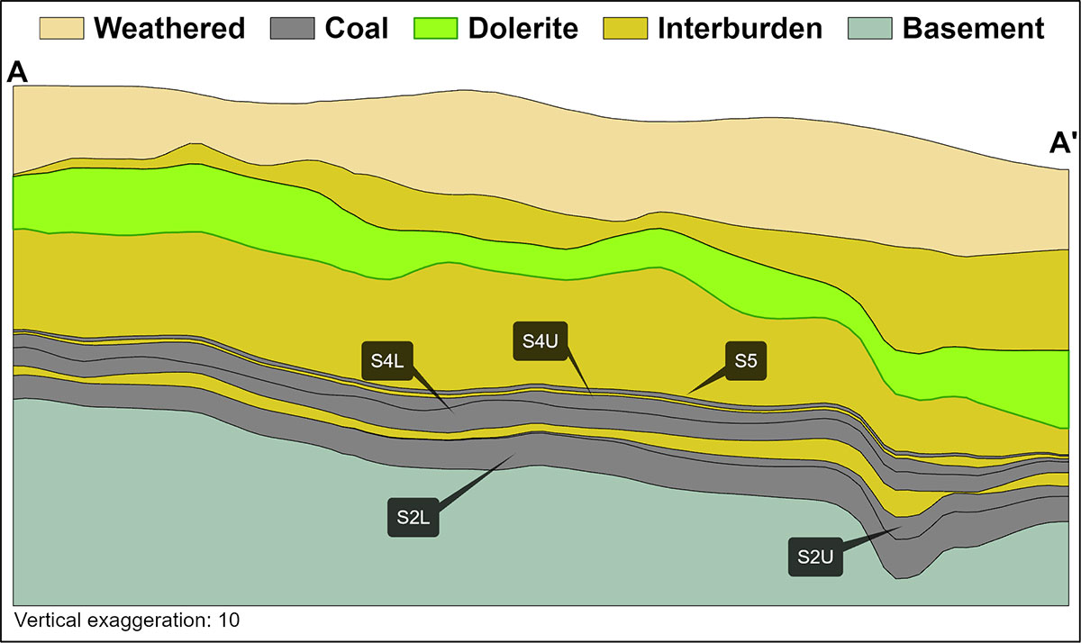
| Coalfield | Leeuwpan mine is in the Delmas coalfield, on the western border of the Witbank coalfield. The geology within the Delmas coalfield is similar to that of the Witbank coalfield. Like the Witbank coalfield, the Delmas coalfield has up to five coal seams in the middle Ecca group sediments of the Karoo supergroup. The Karoo sequence in the area is represented by the Dwyka formation and the middle Ecca with little or no lower Ecca development. The middle Ecca sequence of coal horizons, interbedded with sediments, is highly truncated due to erosion with minor areas where the full sequence is developed. The basement is generally the Malmani dolomites from the Transvaal supergroup. |
||
| Main seams | We identified two coal seams at Leeuwpan: top coal (TC) seam and bottom coal (BC) seam. The BC seam correlates with the S2 of the Witbank and Highveld coalfields and the TC seam correlates with S4 and S5. The BC seam qualities are generally higher than the TC seam qualities. | ||
| Seam development | The coal seams at Leeuwpan are primarily interbedded with sandstone, shale and carbonaceous shale. | ||
| Depositional control | The coal was deposited on glacial sediments of Dwyka tillite, which in turn was deposited on the dolomite of the Transvaal supergroup. A significant amount of magma intruded as concordant sills of dolerite in the Karoo strata in the Delmas area. Thin dolerite dyke structures that transgress the stratigraphy are associated with the dolerite intrusion. Factors controlling geological and quality continuity are mainly surface weathering, significant variation in seam thickness due to an undulating tillite floor, faulting associated with dolerite activity and dolomitic basement, and devolatilisation and weathering due to dolerite intrusions (sills and dykes). | ||
| Resources and Reserves | Coal Resources and Coal Reserves occur in opencast pits OI, OL and UB. | ||
| Mining method | Leeuwpan is an opencast operation with Reserves in various pits mined simultaneously. Current mining operations are on the OL and OI Reserves. The mine uses a conventional truck-and-shovel mining method. | ||
| Beneficiation | Leeuwpan has two DMS plants that beneficiate coal primarily for the thermal export market and two crushing plants (C&S and bypass plants) that handle selectively mined thermal coal either for the domestic market or the export market, depending on the quality. The second DMS plant, commissioned in 2016, is operated by an independent contractor, whereas the original plant is operated by Exxaro. | ||
| Product | The dry crushing and screening plants are capable of producing either a 4 200kcal/kg, 4 800kcal/kg or 5 300kcal/kg product depending on the inherent coal qualities. | ||
| Market | Leeuwpan supplies domestic and export markets. | ||
| Mining right | Leeuwpan has an approved mining right that covers 4 269ha. Execution is pending following a section 102 application to consolidate the two mining rights. | ||
| Environmental approvals | Environmental authorisations are in place for the declared Reserves. | ||
| Projects/feasibility studies | None | ||
Table 25: Resource estimation methodology and reporting
| Process | Information | ||
| Drilling, logging and sampling | Vertical surface drill holes are drilled and subsequently logged on site. Lithological codes are used when capturing the lithology. Photographs of the core are taken after marking it. Samples are split on the lithological contact, if needed, using a chisel and hammer to ensure a clean break. Each sample is put in an individual bag with all materials represented in that interval, ensuring no contamination occurs between the materials to be sampled. Two sample tags are marked using a permanent marker. One sample tag is placed inside the bag and the other on the outside; the bag is then sealed with a cable tie. |
||
| Laboratory and accreditation | SGS, SANAS T0561 | ||
| Laboratory dispatch and receiving process | All samples collected and bagged are registered in a sample sheet, which is also used as a dispatch sheet. The receiving laboratory personnel sign the dispatch sheet after ensuring that the number and sample ID on the dispatch sheet match the samples to be analysed. Once the laboratory receives and signs the dispatch sheet, it is responsible for safekeeping and storing that batch of samples. | ||
| Laboratory QAQC | SGS is accredited for analytical work and participates in monthly local and international round robins. | ||
| Data datum | Cape datum – LO29 | ||
| Drill hole database | acQuire | ||
| Number of drill holes in mining right | 4 616 | ||
| Number of drill holes used for Resource estimation | 733 | ||
| Number of drill holes used for classification 388 | 630 | ||
| Data compositing and weighting | Data compositing is conducted per seam using a weighted value from individual samples that make up the seam, along with each sample's relative density and length. This is conducted in GEOVIA Minex™. | ||
| Data validation | Conducted using queries in acQuire, Minex™ and Excel. | ||
| Geological modelling software | GEOVIA Minex™ | ||
| Estimation technique | Growth algorithm | ||
| Previous model date | 2021 | ||
| Last model update | 2023 | ||
| Grid mesh size | 20m x 20m | ||
| Scan distance | 1 000m | ||
| Data boundary | 200m | ||
| Model build limits | Upper: limit of weathering and topography/collar Lower: basement/Dwyka |
||
| Model outputs | Roof, floor and thickness grids generated for seam structure Raw and wash quality grids |
||
| Changes to modelling process | None | ||
| Thickness cut-off and extraction height considerations | 2023 model ≤0.5m (S5 ≤1m) | ||
| Quality cut-offs (adb) | Ash ≥50%, a non-material amount of coal ≥50% ash may be included to ensure optimised extraction. | ||
| Geological loss applied | 5% to 100% based on geological loss domains (5% standard geological loss is applied but may vary based on the consideration of structural complexity (dolerite sill breakthrough – 50% loss within determined spatial extent and fault displacement zone – 100%) and seam floor adulation (10% loss)). | ||
Table 26: Resource classification criteria
| Category | Type of drill holes | Drill hole spacing | Structurally complex areas | Drill holes/ ha | ||||
| Measured | Cored drill holes with applicable coal qualities | 0m to 100m | May be more conservative after consideration of RODA | 1.04 | ||||
| Indicated | Cored drill holes with applicable coal qualities | 100m to 200m | May be more conservative after consideration of RODA | N/A | ||||
| Inferred | Cored drill holes with applicable coal qualities | 200m to 1 000m | May be more conservative after consideration of RODA | N/A |
Table 27: RPEEE considerations
| Item | Criteria | Criteria met | Comment | |||
| Geological data | Data has been validated and signed off by Competent Person. | Yes | Seam depth, seam thickness ≤0.5m all seams except S5 thickness ≤1m, ≥50% ash content but a non-material amount of coal with ≥50% ash may be included to ensure optimised extraction. Coal qualities are reported on an adb. | |||
| Geological model | Geological model was considered and signed off. | Yes | 2023 | |||
| Structural model | Structural model was considered and signed off. | Yes | 2023 | |||
| Mining | Mining assumptions were considered and defined. | Yes | Opencast | |||
| Assurance | Exxaro internal audits and external audit conducted. | Yes | Internal review in 2023 and external audit by EY in 2021. | |||
| Economic evaluation | Exploitation study with economic and mining assumptions, including geotechnical and geohydrological assumptions. | Yes | LoM schedule updated and the evaluation of a new market and a neighbouring resource (2023). | |||
| Environmental | Reasonable demonstration that environmental approvals can be obtained within the context of local, regional and national governmental legislation. | Yes | Current required approvals in place. | |||
| Tenure | Formal tenure must reasonably demonstrate that a mining right approval can be obtained within the context of local, regional and national governmental legislation. | Yes | Mining right valid until 2039 with no impediments noted. | |||
| Infrastructure | Assumptions used should be reasonable and within known or assumed tolerances or have examples of precedence. | Yes | Current infrastructure. | |||
| Market | A potential market for the product with a reasonable assumption that this market is sustainable. | Yes | Current market. Market option review for low volatile coal. |
Table 28: Reserve estimation
| Topic | Information | ||
| Software | OCCS | ||
| Reserving process | Reserve scheduling is determined using a mine scheduling application (Scheduler) from OCCS, which is the same software used to develop the LoMP schedule. The geological 3D model used for the Resource statement is referred to as the Reserve geological 3D model. The geological model is supplied to mining, projects and technology in the form of Minex™ grids. The grids are then imported into a reserving application (Reserver) from the same OCCS software. This application validates the geological information received by checking the integrity of the geological structure and its quality, ensures wash table values are consistent, and converts the geological 3D model into mineable block sizes. Careful product selection and balancing of remaining Reserves is required at Leeuwpan to ensure maximum value for Exxaro. |
||
| Conversion classification | Indicated Resources are generally converted to Probable Reserves and Measured Resources to Proved Reserves, after consideration of all applicable modifying factors. If one or more of the modifying factors have not been fulfilled, a Measured Resource is either not converted or the Measured Resource is converted but downgraded to a Probable Reserve and the associated risk is clearly stated. This is the case for UB, where it is classified as a Probable Reserve because of additional modifying factors such as low volatiles and the limited market for this particular quality of coal. Inferred Resources are not converted to Coal Reserves. | ||
| Inferred Resources inside LoM | No Inferred Resources inside LoM. | ||
Modifying factors |
|||
| Average thickness cut-off | S2 ≤0.8m, S3 and S4 ≤1.0m | ||
| Quality cut-offs | N/A | ||
| Mining loss | S5 0.31m, S4U 0.12m, S4L 0.12m, S2U 0.5m, S2L 0.12m, UB S2 0.26m. | ||
| Boundary pillar | 100m boundary pillar along the new R50 road at OI West pit. | ||
| Dilution | S5 0.05m, S4U 0.11m, S4L 0.12m, S2U 0m, S2L 0.11m, UB S2 0.25m. | ||
| Contamination | Included in the rest of the modifying factors. | ||
| Mining recovery efficiency | Included in the rest of the modifying factors. | ||
| Planned average slope angles | 45 degrees. For highwall stability, soft material is mined at least one strip ahead of hard material and coal mining activities. | ||
| Practical plant yield | 90% DMS and 90% Fraser Alexander DMS with slimes loss on DMS of 9% and 15% on Fraser Alexander DMS. | ||
| Strip ratio cut-off | Strip ratio is determined using the energy strip ratio assessment and is considered in the reserving process using the economic model to get mining boundaries. | ||
| Environmentally sensitive areas | Environmentally sensitive areas applications made and approval acquired before mining. | ||
| Legal | Applicable mining right considered and all the reserved areas are within the mining rights boundary. | ||
| Social | Applicable communities considered. Socially sensitive areas in the mining right (such as graveyards) are excluded from Reserves in the reserving process. | ||
| Geohydrological | Applicable surface and groundwater models are considered. The pit floor was considered to minimise water handling in the pit face. | ||
Table 29: Leeuwpan Coal Resources and Coal Reserves statement
| Category | 2023 (Mt) | 2022 (Mt) | Difference in tonnes (Mt) | Difference (%) | Reason for change | |||||
| Measured | 63.4 | 65.8 | (2.4) | (4.0) | The decrease is due to depletion (4.4Mt), disposals (1.3Mt) and sterilisation (0.9Mt). This was offset by a reconciliation increase of (0.5Mt) and the upgrade of Inferred Resources (3.6Mt). Upgraded resource confidence (3.6Mt). |
|||||
| Indicated | — | — | ||||||||
| Inferred | — | 3.6 | (3.6) | (100.0) | ||||||
| Total Coal Resources | 63.4 | 69.4 | (6.0) | (9.0) | ||||||
| Proved | 30.5 | 36.1 | (5.6) | (16.0) | The decrease is due to depletion (4.5Mt), model refinement (0.8Mt) and sterilisation (0.8Mt), which was slightly offset by reconciliation (0.6Mt). | |||||
| Probable | 3.3 | 3.3 | — | — | ||||||
| Total Coal Reserves | 33.8 | 39.4 | (5.6) | (14.0) |
| • | Rounding of figures may cause computational discrepancies |
| • | Tonnages quoted in metric tonnes and million tonnes (Mt). Coal Resources quoted as MTIS. |
Table 30 outlines exploration for the reporting year. For detailed expenditure, refer to Table 64.
Table 30: Leeuwpan exploration summary
| Objectives | Progress in reporting year | Plans for next reporting year | ||
| Increase confidence in the UB and OI east pits. | OI east pits. No drilling was conducted in 2023 due to contractual challenges. | Planning includes 15 holes; 10 in the UB pit to increase Resource confidence and confirm new seam nomenclature, and the remaining five holes are planned in the OI east area to delineate the Resource boundary. |
Table 31: Leeuwpan risks
| Risk | Description | Mitigation | ||
| Dolerite sill impact on slope stability | Reserve blocks UB and OI have a dolerite sill overlying the coal strata and the sill orientation affects slope stability. | Apply RODA to identify the areas of high geological risk. The bench design is modified based on dolerite dipping towards the seam. |
||
| Dolerite sill impact on coal devolatilisation | The proximity of the dolerite sill may devolatilise or burn the coal seam. | Higher geological losses are applied in the geological model based on the sill's proximity to the seams. An integrated MRM grade control process is implemented, highlighting expected Resource/Reserve anomalies (including dykes, sills and weathering) to the mining team. | ||
| Major/minor faults | Major faults with displacements greater than the seam widths occur between OL and OI. This is also associated with sill transgression. Minor faults cause slight seam displacements which affect coal and quality continuity. | Inclusion in the RODA plan and higher geological losses applied to major fault zones. | ||
| Floor undulations | Undulating floor conditions cause challenging and complicated mining environment (ie reduced production tempos and contamination). | Floor gradient is included in the RODA. Use of floor contours to plan ramp gradients in each Reserve area. |
||
| Coal quality | In-seam quality deviations are generally localised and are associated with minor channel washout. | Continuously monitor quality, integrated into the grade control process. |
||
| Non-compliance to plan (bridge pit) | Delays to mining the OI-OL bridge pit will result in pit room constraints once the OL pit has been depleted. | Developing activity-based planning model to indicate impact of mining OI pit from one face. |
Other than the risks listed on the previous page, there are no known environmental, social, political and governance risks that could potentially impact the exploitation of the Coal Reserves.
Leeuwpan conducted six operational excellence initiatives in 2023 to improve its value add to the core value chain. The focus was on OVB removal to increase coal inventory and plant utilisation. To align with operational excellence and Reserve optimisation, the UB coal was redefined, and the geological model will be updated in 2024. Additionally, Resources outside LoM will be re-evaluated to optimise pit boundary delineation. An activity-based planning model will be built to evaluate the mining options for optimal production.

Leeuwpan technical specialists and Competent Persons. From the left: Justice Kgarume, Maggi Bestenbier, Rofhiwa Malogwa, Teboho Dibate and Phenyo Thobejane