


| Mining commenced | 1983 |
|---|---|
| Type of mining | Underground |
| Market | Captive market |
| Beneficiation | Crush and screened |
| Products | Eskom exclusive |
| Year-on-year RoM | ↓ 2% due to pit room constraints. RoM 2% higher than budget |
| Year-on-year product | ↓ 2% due to pit room constraints. Product 2% higher than budget |
| Exploration | 18 drill holes drilled |
| Year-on-year Resources | ↓ 3% mainly as a result of depletion, new information that led to disposals and sterilisation |
| Year-on-year Reserves | ↓ 6% mainly as a result of depletion, methodology change and model refinement |
| Remaining LoM | 1+ years |
| Opportunities/operational excellence | A coal washability study to improve RoM qualities has kicked off. Additional drilling in 2024 will augment the coal washability quality information guiding the project. |
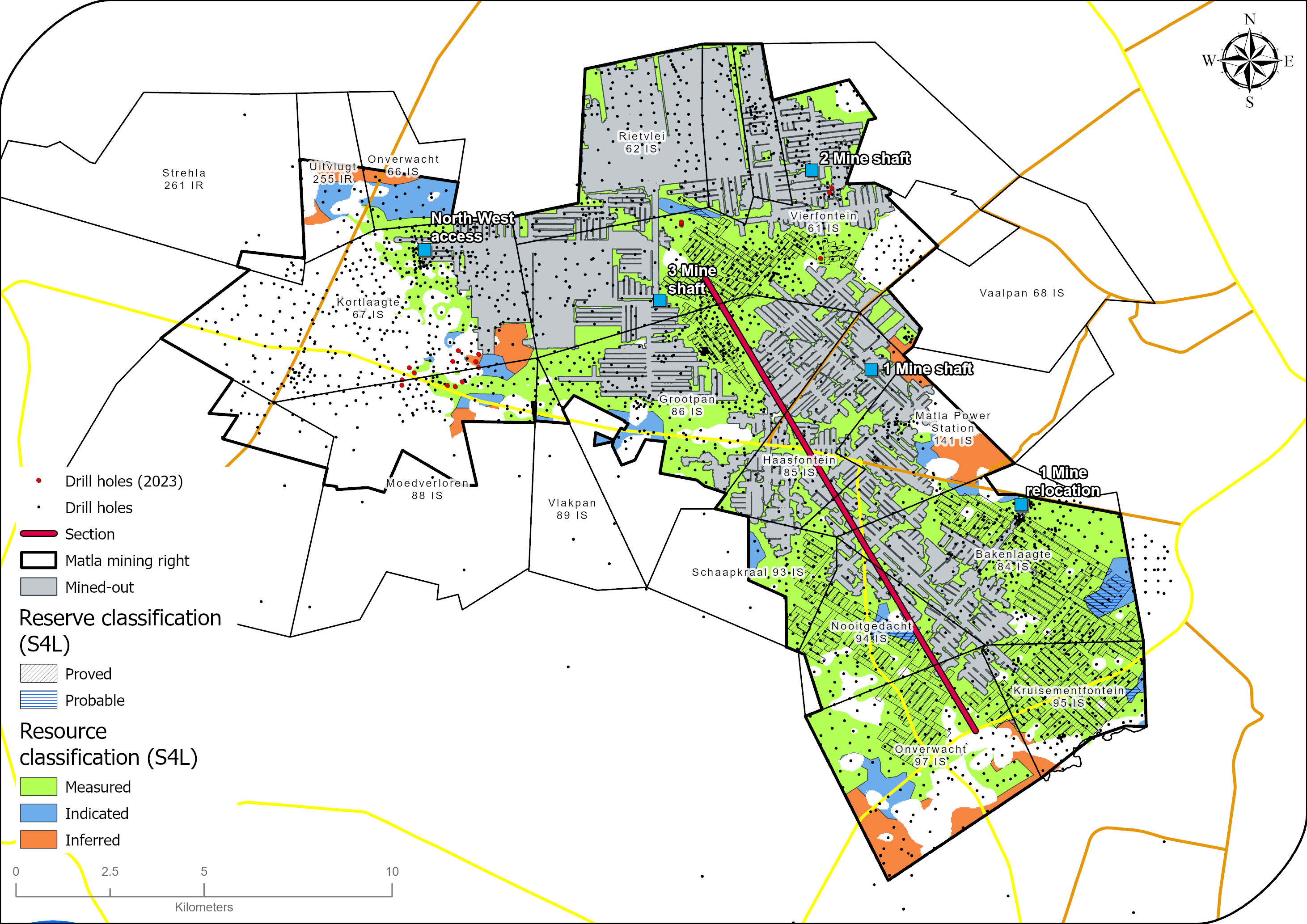
The three major LoM projects that will unlock access to 85% of the current LoM are still ongoing. The NWA incline project at Mine 2 successfully completed drop raises and mined 105.8Kt in 2023 whereas the NWA decline project at Mine 3 successfully reached Seam 2 in October 2023.
Through operational excellence and teamwork, Matla achieved the 2023 budget tonnes notwithstanding pit room challenges. Due to delays in project implementation, mining has been conducted in areas that were previously not in the LoM due to quality and thickness considerations. The mining of these Resource areas contributes to the current coal quality challenges experienced, which will be alleviated once the projects are implemented.
Table 32: Matla overview
| Topic | Information | ||
| Location | 15km west of the town of Kriel in Mpumalanga, South Africa. | ||
| History | Previous ownership | Material notes | |
| 1976 to 1990 | Trans Natal Mines | Construction began in 1976 with full production in 1983. ~465 exploration drill holes drilled. | |
| 1990 to 2006 | Eyesizwe | Mining rights ceded to Exxaro in 2006. Continuous exploration drilling ~1 000 drill holes. | |
| 2006 to 2022 | Exxaro | Full production until Mine 1 closure in 2016. Mine 2 and Mine 3 continue to produce ~6Mtpa with ongoing exploration drilling to support operations. Continuous exploration drilling ~1 840 drill holes. | |
| 2023 | Exxaro | Depletion of OI west mining area. All areas were updated to Measured status. | |
| Adjacent properties | Seriti’s Kriel Colliery neighbours Matla to the east and Zibulo (Seriti) and Khutala (Thungela) are situated to the north. | ||
| Infrastructure | Matla is situated on the P53-1 and R547 secondary roads branching off the R580 and R545. Existing infrastructure supporting the three shaft complexes includes three ventilation shafts, a network of conveyor belts, coal silos and stockpiles, a crushing and screening plant, four pollution-control dams, a hospital, accommodation facilities, offices, workshops and a water treatment plant. Potable water is received from Eskom and no potable water plant exists on the mine property. Electricity is sourced from Eskom (Matla power station). All coal is conveyed from the mine directly to Eskom’s Matla power station. | ||
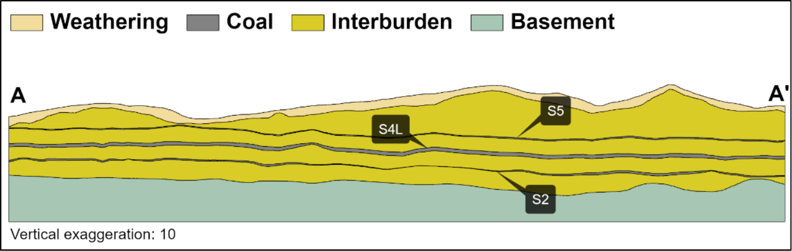
| Coalfield | Matla mine is situated in the Highveld coalfield to the south of the Witbank coalfield. The coal seams are developed in the Vryheid Formation of the Karoo supergroup. The stratigraphic sequence in the Matla area includes five coal seams that can be easily correlated with seams found in the Witbank coalfield. |
||
| Main seams | The principal economic seams currently exploited are S2 and S4, with mining of S5 terminated in 1998 due to high levels of contamination and a subsequent increase in the abrasive index. | ||
| Seam development | Coal seams in the area are generally flat and continuous with subsequent igneous activity resulting in displacements and devolatilisation of coal seams in localised areas. The S5 is most prominent in the Mine 2 and Mine 3 areas and, to a limited extent, in the western limb of the southern part of the mining right area. The roof comprises approximately 0.5m of thick sandy micaceous shale at Mine 2 that thickens up to approximately 1.6m in Mine 3. The seam consists of mixed coal and torbanitic material with an average thickness of 1.5m. Economic S4 exists in the Mine 1, Mine 2 and Southern Reserve areas and, to a limited extent, in the Mine 3 area. At Mine 3, the seam splits into two thin, poor quality horizons towards the west and is thus excluded from the mineable Reserves. The best quality S4 is located at Mine 1 and at the eastern edges of Mine 2. The seam is composed of dull lustrous coal interspersed with bright coal bands. In-seam partings typically consist of discontinuous lenses of shales and siltstones less than 0.1m thick, but these may thicken locally to 0.3m. Carbonaceous limestone lenses are also prevalent within the central portion of the Mine 2 area. The S2 at Matla is well developed in the north-western part of the mining area in the Mine 2 and Mine 3 Resource areas. It thins out to the south, where the thickness averages between 1.2m and 2.5m. Much of the coal in this area is mined as a low seam. The S2 between Mine 1 and Mine 2 has been burned by a prominent dolerite sill and is thus unmineable. S2 in the Mine 1 area is generally poor quality and discontinuous due to sill activity. As such, it is not mined in this area. | ||
| Depositional control | The coal was deposited on glacial sediments of Dwyka tillite, which in turn was deposited over a granitic basement. The Matla mining area is characterised by two distinct dolerite types – the B8 (porphyritic) and B4 (olive-rich) types – which have varying effects on seam displacements and coal burning and devolatilisation. A dolerite sill with an average thickness of 10m is generally found above S5 in Mines 2 and 3. However, the sill intersects the coal seams and underlies S2 in Mine 1 and S4 on the south-western part of the Reserves. This sill has burned and devolatilised S2 on the southern part of the mining area in Mine 1. Floor rolls have been encountered in S2 workings, creating challenges in isolated mining areas. The floor rolls strike north-east-south-west, vary in width between 50m and 200m and have amplitudes up to 1.5m. The floor rolls are more prominent if the seam floor is close to the basement contact. Sandstone lenses encountered are generally less than 0.5m in width but can reach up to 1.5m in thickness. | ||
| Resources and Reserves | Coal Resources and Coal Reserves occur within the domains of Mines 1, 2 and 3. The Coal Reserves align with the existing LoMP. The reporting of LoM is restricted to the mineral right lapse date, although there are Coal Reserves well beyond this date. | ||
| Mining method | Matla comprises three underground production facilities: Mine 1, Mine 2 and Mine 3. All three are long-life assets, each with a specific operating capacity comprising conventional coal circuits to produce bituminous coal. Production at Mine 1 was stopped in 2015 due to pillar instability and is planned to resume in 2025. Mines 2 and 3 use bord-and-pillar methods to mine S2 and S4. Shortwall mining is also utilised to conduct mining of S2 in Mine 2 and this is scheduled to cease in 2024. | ||
| Beneficiation | None of the coal mined at Matla is beneficiated, but it is crushed and screened (sized) before being conveyed to the power station. | ||
| Product | Matla mine produces thermal coal exclusively for Eskom. | ||
| Market | Captive market: Eskom. | ||
| Mining right | Matla has an approved mining right that covers some 23 494ha. | ||
| Beneficiation | None of the coal mined at Matla is beneficiated, but it is crushed and screened (sized) before being conveyed to the power station. | ||
| Product | Matla mine produces thermal coal exclusively for Eskom. | ||
| Market | Captive market: Eskom. | ||
| Mining right | Matla has an approved mining right that covers some 23 494ha. Environmental approvals The IWUL has expired, but a formal process is in place for renewal. Discussi | ||
| Environmental approvals | The IWUL has expired, but a formal process is in place for renewal. Discussions and close cooperation with the Department of Water and Sanitation (DWS) are ongoing. | ||
| Projects/feasibility studies | Three major LoM projects exist at Matla, namely the Matla Mine 1 relocation project (MM1R), the Mine 2 north-west access incline project and the Mine 3 north-west access decline project. The MM1R project is currently in progress and includes the construction of a box cut, portals (declines from the box cut to access UG workings), silos and overland conveyors which creates a new access point to Mine 1, with conveyor infrastructure transporting the coal directly to Matla power station. The box cut and associated sumps, carbonaceous stockpiles and water storage infrastructure were completed in 2022. The portals were completed in December 2022, with successful holing into the old mine workings. Remaining work entails conveyor belt structures and plant facilities for the coal transport from the mine to the existing Matla plant. Production from MM1R is expected in 2025. However, an early coal strategy is targeting the production of coal from Mine 1 in 2024, where the coal will be trucked to the Matla stockyard until the final overland conveyor and associated infrastructure has been completed. The north-west access incline project entails the construction of an incline from the S2 to the S4 to access the future LoM Reserves at Matla Mine 2. The incline intersected S4 coal in September 2022. The inclines were completed and the drop raises were completed in November 2023. Final civil works and conveyor infrastructure will be completed in the first quarter of 2024 before commencing production from this project. A total of 105 886 tonnes was mined from the incline project in 2023 while construction of the drop raises was ongoing. The north-west access decline project entails the construction of a decline from the S4 to the S2 at Mine 3. The project was stopped between 2020 and 2022 but recommenced in November 2022. The decline intersected the target S2 in September 2023. Run-arounds and pit room space creation on the S2 are still outstanding, along with the construction of a permanent conveyor belt and associated civil structures. Mining will commence at the project in 2024. Due to a requirement by the Eskom-owned Matla power station to review and potentially increase the quality specification of coal used for electricity generation, various coal quality improvement studies have been initiated during 2023. The option to beneficiate the coal requires additional exploration sample washability data, which has been scoped and planned to start in 2024. The drilling to obtain the relevant data will run over three to four years and target the S4 at Mine 1 and Mine 2 and the S2 at Mine 3. The information will be critical in the evaluation of washability characteristics, which will be used as the basis for quality improvement initiative studies. |
||
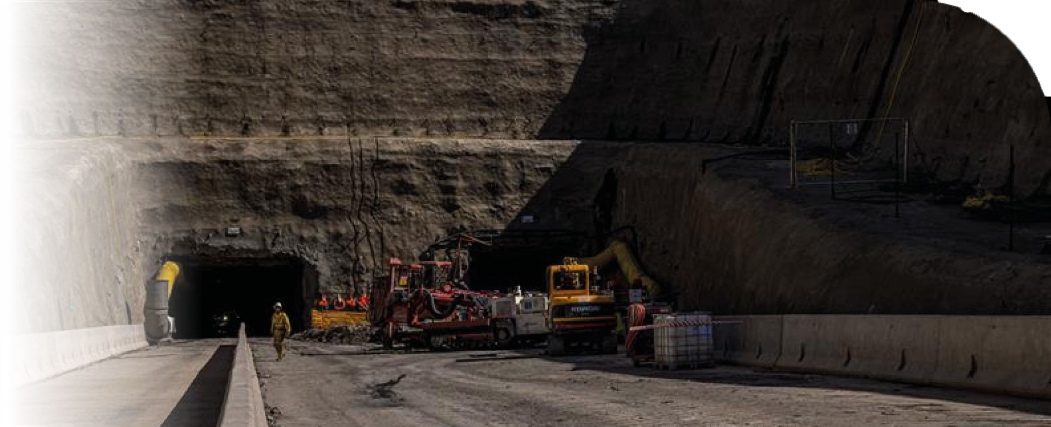
The new entrance to Matla Mine 1
Table 33: Resource estimation methodology and reporting
| Process | Information | ||
| Drilling, logging and sampling | Surface vertical, surface inclined and underground horizontal drilling methods are employed at Matla. Only the vertical surface drill holes are used for Resource modelling. All drill holes are geologically logged on a detailed log sheet with the content dictated by the Exxaro logging procedure. Logging is conducted by recording of lithology down to 1cm detail on logging sheets, according to the classification of the lithology. Once all core and sample markings are in place, the core is photographed on a 1m interval basis. Once correlated, sample intervals are defined based on lithological contacts and logical boundaries along the drill hole, across the named intervals or seams. If the entire unit is homogenous, samples are then collected at 1.5m intervals. All samples are placed into plastic sample bags and a sample tag is placed inside the bag with a duplicate attached to a cable tie on the bag’s exterior. The sample tags are used to identify the samples according to a sampling convention, which is recorded in the log sheet and geological database to allow the laboratory results to be assigned to the correct interval in each specific drill hole. |
||
| Laboratory and accreditation | SGS South Africa, SANAS T0561 | ||
| Laboratory dispatch and receiving process | All samples are allocated unique alphanumeric IDs corresponding to the associated drill hole ID, seam sampled and number of the individual sample. These samples are collected, bagged and registered in a sample sheet which is also used as a dispatch sheet. All exploration samples are weighed on site prior to dispatch and recorded at the mine. The laboratory reports the weight of each individual sample and these results are compared to the mine weights to validate that the correct samples were conveyed properly and safely to the laboratory. The receiving laboratory personnel sign the dispatch sheet after ensuring that the number and sample ID on the dispatch sheet match the samples to be analysed. The analyses required are also clearly explained in the sample dispatch sheet. All sample results are validated following a standard procedure including visual, logical and mathematical verification before acceptance and capture into the mine’s database. | ||
| Laboratory QAQC | As part of the procurement process, Matla conducted QAQC on various laboratories. | ||
| Data datum | Cape datum – LO29 | ||
| Drill hole database | acQuire | ||
| Number of drill holes in mining right | 2 694 | ||
| Number of drill holes used for Resource estimation | S2 – 1 921 S4 – 2 479 |
||
| Number of drill holes used for classification 388 | S2 – 1 921 S4 – 2 479 |
||
| Data compositing and weighting | Data compositing is conducted per seam using a weighted value from individual samples that make up the seam, along with each sample's relative density and length. This is conducted in GEOVIA Minex™. | ||
| Data validation | Conducted using queries in acQuire, Minex™ and Excel. | ||
| Geological modelling software | GEOVIA Minex™ | ||
| Estimation technique | Growth algorithm | ||
| Previous model date | 2022 | ||
| Last model update | 2023 | ||
| Grid mesh size | 25m x 25m | ||
| Scan distance | 2 000m | ||
| Data boundary | 200m | ||
| Model build limits | Upper: limit of weathering and topography/collar Lower: basement/Dwyka |
||
| Model outputs | Roof, floor and thickness grids generated for seam structure. Raw quality grids. | ||
| Changes to modelling process | None | ||
| Thickness cut-off and extraction height considerations | ≤1.8m | ||
| Quality cut-offs (adb) | DAFV ≤ 26% CV ≤15MJ/kg, Ash ≥50% |
||
| Geological loss applied | 10% (may vary considering RODA) | ||
Table 34: Resource classification criteria
| Category | Type of drill holes | Drill hole spacing | Structurally complex areas | Drill holes/ ha | ||||
| Measured | Cored drill holes with applicable coal qualities | 0m to 350m | Infill drilling is conducted where basement highs and or seam structure create uncertainty around continuity. | S2 – 0.14 S4 – 0.13 |
||||
| Indicated | Cored drill holes with applicable coal qualities | 350m to 500m | Infill drilling is conducted where basement highs and or seam structure create uncertainty around continuity. | S2 – 0.04 S4 – 0.05 |
||||
| Inferred | Cored drill holes with applicable coal qualities | 500m to 1 000m | Infill drilling is conducted where basement highs and or seam structure create uncertainty around continuity. | S2 – 0.02 S4 – 0.02 |
Table 35: RPEEE considerations
| Item | Criteria | Criteria met | Comment | |||
| Geological data | Data has been validated and signed off by Competent Person. | Yes | Seam depth ≤40m, seam thickness ≤1.8m, dry ash free volatiles ≤26%, CV≤15MJ/kg and ash ≥50% with coal qualities reported on an adb. | |||
| Geological model | Geological model has been considered and signed off. | Yes | 2023 | |||
| Structural model | Structural model was considered and signed off. | Yes | 2023 | |||
| Mining | Mining assumptions considered and defined. | Yes | Underground | |||
| Assurance | Exxaro internal audits and external audit. | Yes | Internal review 2023. | |||
| Economic evaluation | Exploitation study with economic and mining assumptions, including geotechnical and geohydrological assumptions. | Yes | LoM schedule revised to align with project dates (2023). | |||
| Environmental | Reasonable demonstration that environmental approvals can be obtained within the context of local, regional and national governmental legislation. | Yes | Current required approvals in place. An application for stooping was submitted and there is a reasonable expectation that the approval will not be withheld. Surface acquisitions for future stooping can be achieved based on the current acquisition strategy. | |||
| Tenure | Formal tenure must reasonably demonstrate that a mining right approval can be obtained within the context of local, regional and national governmental legislation. | Yes | The mining right expires in 2025. Application to renew is in progress and there is reasonable expectation that it will be renewed with no impediments noted. | |||
| Infrastructure | Assumptions used should be reasonable and within known or assumed tolerances or have examples of precedence. | Yes | Current infrastructure. | |||
| Market | A potential market for the product with a reasonable assumption that this market is sustainable. | Yes | Current coal supply agreement (CSA) in place until June 2024. Extension period and terms under negotiation. All considerations remain. Exxaro has reasonable expectation that the CSA will be renewed. |
Table 36: Reserve estimation
| Topic | Information | ||
| Software | Underground Coal Solution (UGCS) | ||
| Reserving process | Scheduling of the Coal Reserve is determined using mine scheduling applications from UGCS. The geological 3D model used for the Coal Reserve estimation is referred to as the Reserve 3D model. The Coal Resource model uses the full coal seam while the Reserve model only defines a select mining height. The process ensures the model represents reality regarding the technical capability of current production equipment. Resources are converted to Reserves where the Resource confidence, continuity and other factors (including economic, environmental, safety and social aspects) allow for the reasonable expectation of successful extraction. Reserves are converted using modifying factors which account for layout design and associated losses. The Reserves stated are subject to verification according to an approved fact pack which sets out the standards and considerations for all reserving and scheduling processes. This document is reviewed annually and vetted by all relevant stakeholders. |
||
| Conversion classification | At Matla, Indicated Resources are generally converted to Probable Reserves and Measured Resources to the Proved Reserve category, except if any modifying factors have not been (partly) fulfilled, where the Resource is either not converted or downgraded to the Probable Reserve category, clearly stating the outstanding requirement and risk. | ||
| Inferred Resources inside LoM | Some 5Mt of Inferred Resources are included in the LoMP, representing 3.2% of the LoMP, and are not considered material. | ||
Modifying factors |
|||
| Average thickness cut-off | ≤1.8m, low seam ≤2.1m, high seam ≤3.6m and ≥4.8m. | ||
| Quality cut-offs | DAFV ≤26% and minimum individual areas of 18.5Mj/kg AD CV are delineated in the geological model and used as exclusion zones for the mine plan. All areas of less than 17.0Mj/kg AR CV are excluded from the mine plan, unless required for development. | ||
| Mining loss | Already included in the model, based on specific geological conditions and mining restrictions. | ||
| Depth to roof | 40m unless rock strength allows otherwise. | ||
| Safety factor | Main development >2.1, secondary panels >1.8 and tertiary panels >1.6. | ||
| Bord width | <7.5m | ||
| Barrier pillar | Main development 19m, secondary and tertiary panels 17m. | ||
| Pillar centres | Main development 24m, secondary panels 20m and tertiary panels 19m. | ||
| Boundary pillar | Main development 24m, secondary and tertiary panels 17m. | ||
| Mining height | Low seam ≤2.1m, high seam ≤3.6m and ≥4.8m. | ||
| Extraction factor | Low seam 58%, S2 48%, S4 50% and 100% for shortwall mining. | ||
| Dilution | Already included in the model. | ||
| Contamination | Low seam 2.1m plus 10cm roof cut. Other seams 7cm roof cut. | ||
| Practical plant yield | N/A | ||
| Strip ratio cut-off | N/A | ||
| Environmentally sensitive areas | Areas underlying wetlands and other eco-sensitive areas are excluded from Reserves. A higher safety factor is used underneath rivers and surface structures. | ||
| Legal | Reserves are downgraded from Proved to Probable where surface ownership is pending for stooping. | ||
| Social | Applicable communities considered. | ||
| Geohydrological | Applicable surface and groundwater models considered. | ||
Table 37: Matla Coal Resources and Coal Reserves statement
| Category | 2023 (Mt) | 2022 (Mt) | Difference in tonnes (Mt) | Difference (%) | Reason for change | |||||
| Measured | 63.4 | 657 | (23) | (4) | The decrease is the result of depletion (10.1Mt), new information (4.3Mt) and sterilisation (9.2Mt). The increase is due to new information (1.1Mt). The decrease is the result of depletion (0.2Mt), new information (0.2Mt) and sterilisation (1.1Mt). |
|||||
| Indicated | 92 | 91 | 1.4 | 2 | ||||||
| Inferred | 85 | 3.6 | (2) | (3) | ||||||
| Total Coal Resources | 810 | 87 | (25) | (3) | ||||||
| Proved | 126 | 130 | (4) | (3) | The decrease is mainly due to depletion (5.4Mt) and the update of the LoMP (1.1Mt). This was offset by upgraded Probable Reserves (2.1Mt). The decrease is due to an upgrade of Probable Reserves (2.1Mt) and reconciliation (4.7Mt). |
|||||
| Probable | 31 | 38 | (7) | (18) | ||||||
| Total Coal Reserves | 157 | 167 | (10) | (6) |
| • | Rounding of figures may cause computational discrepancies. |
| • | Tonnages quoted in metric tonnes and million tonnes (Mt). Coal Resources quoted as MTIS. |
Table 38 outlines the exploration for the reporting year. For detailed expenditure, please refer to Table 64.
Table 38: Matla exploration summary
| Objectives | Progress in reporting year | Plans for next reporting year | ||
| Drill at low seam access areas and additional short-term information at Mine 3 S4 and Mine 2 S2. | As a result of the contractual and timely availability of service providers, only 18 of the planned 30 holes were completed. Better resource definition was achieved, ensuring coal continuity and coal quality information. |
A new drilling tender is progressing well to ensure an additional three rigs to ramp up to 80 holes. The objective is to obtain samples for washability test work to support the Matla quality improvement study. |
Table 39: Matla risks
| Risk | Description | Mitigation | ||
| Limited pit room due to project execution delays | Approximately 85% of the current Reserves are within the delayed expansion projects. The delayed LoM expansion projects have resulted in limited pit room availability with the risk of having to mine in structurally complex and or low-quality coal areas. | Continuous investigations on accessing new mining areas that were previously excluded from the LoM either due to quality, structural complexity or geological confidence. Layouts optimised to achieve RoM blend of required product quality. |
||
| Geological structures | High-risk geological structures impact mining due to ground stability and the need to develop through these structures to access mineable Reserves. Structures include dolerite sills and dykes, faults and jointed ground within known shear zones. | Structure delineation is conducted through surface directional and underground horizontal drilling, targeting structures defined using geophysical interpretation. The resultant structural data informs the mine plan layout, orientation, roof and sidewall support during excavation. | ||
| Eskom purchasing of surface farms to commence with stooping | Stooping is a total extraction mining method that will have an impact on the surface farmland. Require ownership of farms where stooping is planned. | Eskom to purchase surface ownership of a list of farms as per CSA. Stooping ground below private land is reported as Probable Reserves. | ||
| Environmental authorisation for stooping | The environmental management plan for total extraction during stooping can commence when land ownership has been secured. | Eskom to purchase surface ownership of a list of farms as per CSA. |
||
| Economic | Eskom CSA expired in June 2023 and has been extended by one year. Terms of the extension are under negotiation between Exxaro and Eskom, which will define the outcome of the agreement at the end of the current extension. This risk carries implications for the mine contract extension as well as the potential change in product quality specification that will impact the current LoM assumptions. | There is reasonable expectation for the renewal of this contract. Ongoing projects for LoM expansion are in progress along with constant communication on the contractual way forward post-June 2024. |
||
| Tenure | Mining right expires in 2025. | The updated mine works programme is completed and under review, to be submitted in the first quarter of 2024 in line with the requirements from the director general. There is a reasonable expectation that the extension will be granted. |
Other than the risks listed above, there are no known environmental, social, political and governance risks that could potentially impact the exploitation of the Coal Reserves.
85% of Reserves are inaccessible due to project implementation delays, with full production scheduled for 2027. The delays in project completion have resulted in the requirement to identify additional mining areas through additional drilling and short-term interpretations to evaluate viability for short-term mining to safeguard production. The exploration targeted thicker coal seams at Mine 3 S2 low seam to reduce contamination and improve the overall quality mix. Geological and geotechnical studies were undertaken to improve the understanding of structurally complex conditions in previously unmineable areas in Mine 3 S4. A high resolution geological and rock engineering model was built to guide mining in the shortwall section. The success of these initiatives is evident in producing RoM that exceeded the 2023 budget, an outstanding achievement for Matla given the existing pit room constraints.

From the left: Mark Dimmick-Touw (Matla Resource Competent Person) and Thato Moabi (Matla Reserve Competent Person)