


| Mining commenced | 2018 (Nooitgedacht) |
|---|---|
| Type of mining | Opencast |
| Market | Export |
| Beneficiation | Two-stage DMS plant |
| Products | CV 4 600kcal/kg and 5 800kcal/kg net as received |
| Year-on-year RoM | ↓ 12% mining ceased in Patattafontein as a result of competing mining right applications, altering the LoM schedule to resume mining once resolved |
| Year-on-year product | ↓ 10% impacted by the change in RoM schedule |
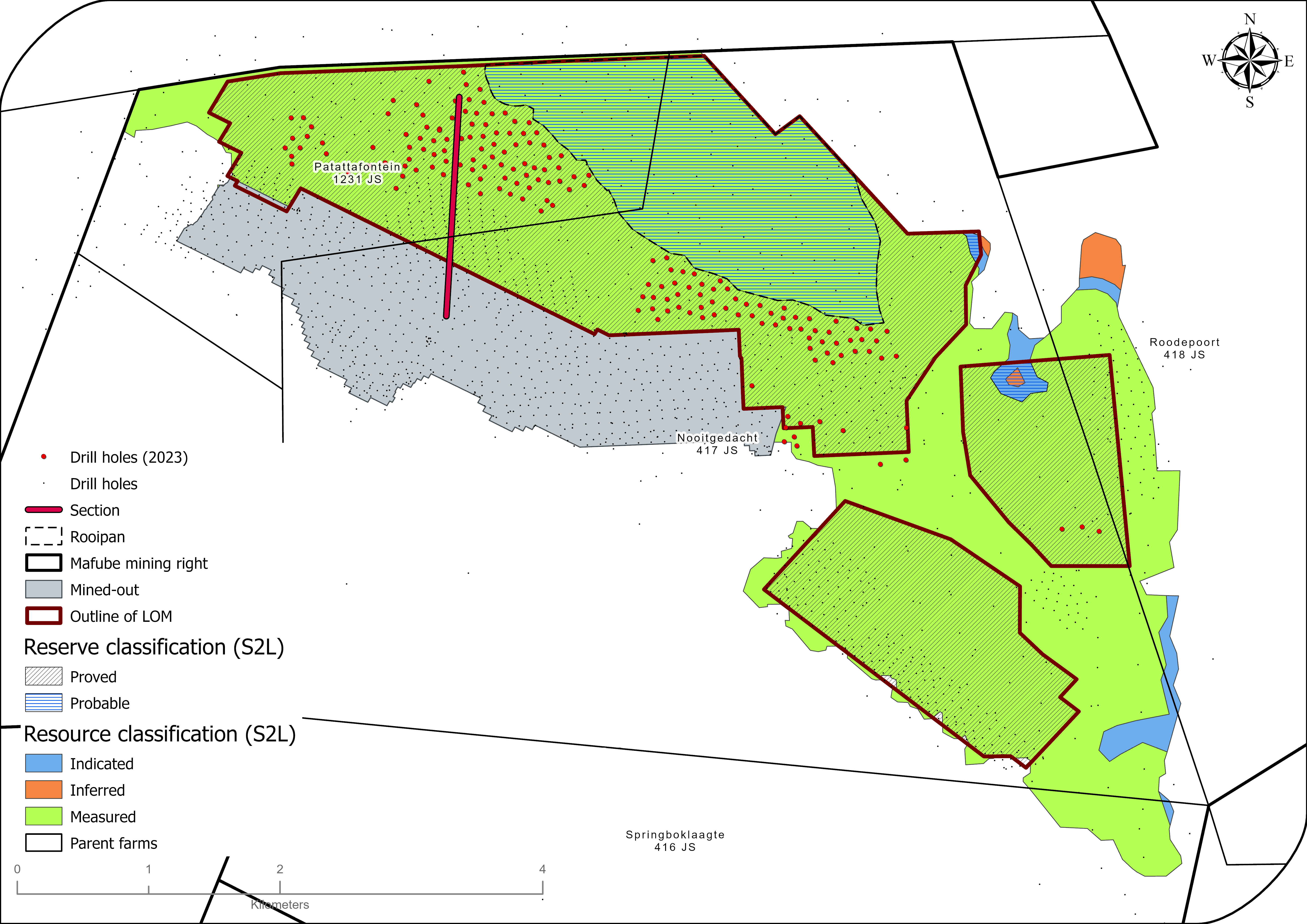
| Exploration | 182 drill holes focused on increasing geological confidence |
| Year-on-year Resources | No change, mainly due to new information offsetting mining depletion |
| Year-on-year Reserves | ↓ 6% as a result of production and excluded area based on environmental considerations |
| Remaining LoM | 20 years |
| Opportunities/operational excellence | Due diligence on S4 exploitation strategy planned for 2024 |
50%
attributable
to Exxaro
Table 56: Mafube overview
| Topic | Information | ||
| Location | 30km east of the town of Middelburg in Mpumalanga, South Africa | ||
| History | Previous ownership | Material notes | |
| 1976 to 1988 | Anglo American Coal | Coal Resource delineation drilling (~900 drill holes). | |
| 1989 to 2006 | Mafube Coal | Coal Resource delineation drilling and five-year mine plan infill drilling (731 drill holes). Mining ceased at Springboklaagte in 2018 and commenced at Nooitgedacht the same year. |
|
| 2007 to 2015 | Thungela | Resource definition drilling to support and derisk the mine plan (~370 drill holes). | |
| Adjacent properties | Most of the properties next to Mafube are owned by the Glencore Operations South Africa Proprietary Limited (Glencore) – Phembani Group’s Umcebo Holdings Mining Proprietary Limited (Umcebo). Other nearby owners of coal rights are Arnot Colliery (now owned by the Arnot OpCo consortium, consisting of former Arnot Colliery employees, communities and Wescoal Holdings Limited); Nucoal Mining (ground to the west of Mafube); Sumo Colliery Proprietary Limited and Optimum Colliery. | ||
| Infrastructure | The mine is accessible by tarred regional roads leading off the N4 national road, and a railway line traverses the property in the north, connecting the rail load-out terminal with the Richards Bay Coal Terminal. Eskom supplies direct bulk power at two points: the main consumer substation adjacent to the coal processing plant and the Overland Conveyor No 3 substation. Potable water is sourced on site per the IWUL specification from three authorised production drill holes at Springboklaagte and one at Nooitgedacht. |
||
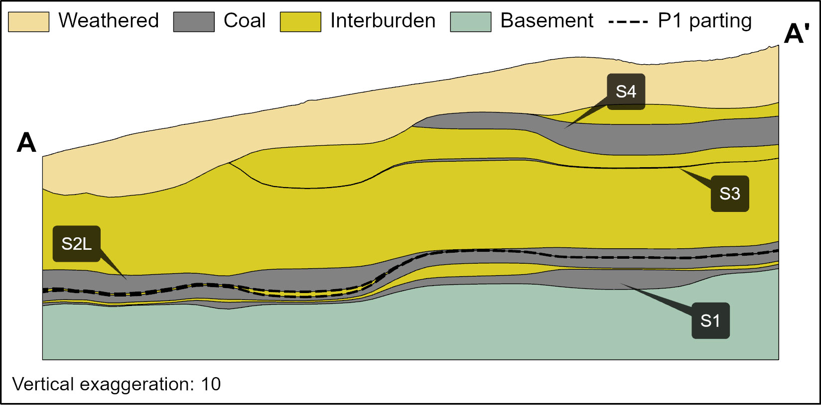
| Coalfield | Mafube mine is situated near the northern edge of the Witbank coalfield. The coalfield extends about 190km east-west between Springs and Belfast, and about 60km in a north-south direction between Middelburg and Ermelo. The Witbank coalfield has up to five coal seams in the middle Ecca group sediments of the Karoo supergroup. The Karoo sequence in the area is represented by the Dwyka formation and the middle Ecca with little or no lower Ecca development. The middle Ecca sequence of coal horizons, interbedded with sediments, is highly truncated due to erosion. Only four of the five main coal seams occur within Mafube, and S5 has been eroded. |
||
| Main seams | S4, S2L and S1. | ||
| Seam development | S4 is confined to the deeper parts (north-west) of the mining area, and S3 is thin and of no current economic significance. An upper sub-seam, designated S2 upper (S2U), is sometimes present. The S2U and S2 lower (S2L) are separated by a thin but distinctive parting (designated S2 parting (P2) with an average thickness of 0.25m). The S2U is fairly thin and consists of poorer quality coal; it is therefore not economic. S2L is the main economic seam with an average thickness of 4.91m. The quality is variable due to interbedded bright and dull coal plies with some shale and carbonaceous shale, mudstone and occasional sandstone bands. S1 is thin (average thickness of 0.75m) and continuous throughout the Mafube area. It lies approximately 0.5m below the S2L. Two minor seams occasionally occur below S1 (designated S1L and S1LL). They are, however, of no economic significance. |
||
| Depositional control | Due to the mine's proximity to the northern edge of the Witbank basin, the primary control of coal development is surface topography and the pre-Karoo basement floor. Despite aeromagnetic tentatively identifying some north-south trending lineaments, there is minor influence from geological faulting, thrusting and intrusions within the Mafube area. These aeromagnetic structures have not been confirmed by subsequent drilling. There are no known major geological structures that may affect the geology or coal seam continuity. | ||
| Resources and Reserves | Resources occur within most of the mining right and are limited by the boundary and the limit of weathering (coal sub-crop), whereas the Reserves are limited by the mining economics aligned with the existing LoMP strategy. | ||
| Mining method | The extraction of coal is based on the opencast mining method. Six opencast pits have been identified as per the LoM. Four to five will operate concurrently. | ||
| Beneficiation | Thermal coal is beneficiated in a two-stage DMS plant. | ||
| Product | CV 4 600kcal/kg and 5 800kcal/kg net as received. | ||
| Market | Export market. | ||
| Mining right | Mafube has two granted and executed new order mining rights that cover 10 933ha in total. We are addressing competing applications. | ||
| Environmental approvals | All environmental approvals and authorisations are in place for the declared Reserves with the exception of the Rooipan Reserves which are reported as Probable pending the approval of the IWUL and environmental authorisations. | ||
| Projects/feasibility studies | The debottlenecking project, which aims to enable an RoM production ramp-up to 7Mt per annum, is currently on hold pending Rooipan IWUL approval. | ||
Table 57: Resource estimation methodology and reporting
| Process | Information | ||
| Drilling, logging and sampling | Mafube has typically used conventional core drilling (diamond drilling) for most of the holes drilled. This produces a 63.5mm diameter solid core for logging and sampling. Full core is usually produced once competent strata have been intersected. Open-hole drilling techniques are employed for the near-surface OVB material (usually by-products of current day weathering). The core is measured, any core loss is identified and recorded, and important geological units are marked off before logging commences. The core is logged by the field geologist responsible for Mafube exploration drilling. Core logging data is recorded manually on the borehole coding sheets (“logging sheets”) using a logical letter coding system (“Dictionary of Codes”). This data is then captured into Excel and imported into the acQuire database where standard QAQC routines ensure the correctness of the data. Since 2019, most vertical surface drill holes have been wireline logged for the purpose of enhanced seam roof and floor mapping to delineate areas of seam floor rolls, seam thinning, seam thickening and seam pinching. Photographs of the core are taken after marking the core. Geological information is captured on log sheets with lithology captured up to centimetre details. Sampling is conducted on site with the aid of wireline logs as per Mafube sampling standard. |
||
| Laboratory and accreditation | Bureau Veritas Inspectorate Laboratories Proprietary Limited and SANAS T0313. | ||
| Laboratory dispatch and receiving process | All samples collected and bagged are registered in a sample control sheet and the sample advice sheet. Once the samples are entered onto the sample control sheet , sample request forms are generated which keep record of samples requested and sent to the laboratory. On receiving the samples, the laboratory personnel ensure that the number and sample identity on the sample request forms match the samples to be analysed. The laboratory personnel then sign the sample request forms in duplicates with one copy remaining at the lab and the other filed by the exploration geologist at the mine. | ||
| Laboratory QAQC | Emphasis is placed on ensuring data integrity through rigorous procedures and supervision while processing. Audits are performed internally and externally as part of the assurance and control process. Bureau Veritas is accredited for analytical work and participates in monthly local and international round robins. | ||
| Data datum | WGS 84 – LO29 | ||
| Drill hole database | acQuire | ||
| Number of drill holes in mining right | 1 836 | ||
| Number of drill holes used for Resource estimation | 1 342 | ||
| Number of drill holes used for classification | S1 – 552 S2L – 1 836 S4 – 126 |
||
| Data compositing and weighting | Data compositing is conducted per seam using a weighted value from individual samples that make up the seam, along with each sample's relative density and length. This is conducted in GEOVIA Minex™. | ||
| Data validation | Conducted using queries in acQuire and Excel | ||
| Geological modelling software | GEOVIA Minex™ | ||
| Estimation technique | Growth algorithm | ||
| Previous model date | 2020 | ||
| Last model update | 2023 | ||
| Grid mesh size | 25m x 25m | ||
| Scan distance | 2 000m | ||
| Data boundary | 200m | ||
| Model build limits | Upper: limit of weathering and topography/collar Lower: basement/Dwyka |
||
| Model outputs | Roof, floor and thickness grids generated for structure Raw and wash quality grids |
||
| Changes to modelling process | None | ||
| Thickness cut-off and extraction height considerations | S1 ≤0.8m, S2L ≤1.0m, S4 ≤1.0m | ||
| Quality cut-offs (adb) | Ash ≥50% | ||
| Geological loss applied | Sub-outcrop/Inferred – 30% Indicated – 12% Measured – 10% |
||
Table 58: Resource classification criteria
| Category | Type of drill holes | Drill hole spacing | Structurally complex areas | Drill holes/ha | ||||
| Measured | Cored drill holes with applicable coal qualities | 0m to 350m | Geoloss domains of 10% | 0.08 | ||||
| Indicated | Cored drill holes with applicable coal qualities | 350m to 500m | Geoloss domains of 12% | 0.04 | ||||
| Inferred | Cored drill holes with applicable coal qualities | 500m to 1 000m | Geoloss domains of 30% | 0.01 |
Table 59: RPEEE considerations
| Item | Criteria | Criteria met | Comment | |||
| Geological data | Data has been validated and signed off by Competent Person. | Yes | Geological structures and depositional extent are considered, as well as seam thickness, with coal qualities reported on an adb | |||
| Geological model | Geological model has been considered and signed off. | Yes | ||||
| Structural model | Structural model was considered and signed off. | Yes | 2023 | |||
| Mining | Mining assumptions considered and defined. | Yes | Opencast | |||
| Assurance | Exxaro internal audits and an external audit conducted. | Yes | External independent review by SRK in 2020. | |||
| Economic evaluation | Exploitation study with economic and mining assumptions, including geotechnical and geohydrological assumptions. | Yes | Mafube early value exploitation strategy and debottleneck project. | |||
| Environmental | Reasonable demonstration that environmental approvals can be obtained within the context of local, regional and national governmental legislation. | Yes | Environmental management plan, IWUL and NEMA licences in place and compliant. Application for authorisation in terms of the NEMWA or in terms of NEMA for the mining of Pan 11 (Rooipan) has been prepared and submitted. The submission was made after the completion of the required technical specialist studies. Final EIR/EMPr was submitted on 30 October 2023 to the Department of Mineral Resources and Energy (DMRE) and on 20 November 2023 to the DWS. Reports are under review for approval. The addition of the designs for the new water uses (PCD) necessitated withdrawal and relaunching in the eWULAAS to amend water uses. Approval from the DWS moved to the third quarter of 2024. |
|||
| Tenure | Formal tenure must reasonably demonstrate that a mining right approval can be obtained within the context of local, regional and national governmental legislation. | Yes | Tenure is secured. Surface right ownership is secured for current LoM. | |||
| Infrastructure | Assumptions used should be reasonable and within known or assumed tolerances or have examples of precedence. | Yes | Existing infrastructure is adequate or can be upgraded with new required infrastructure under construction. | |||
| Market | Potential market for the product with a reasonable assumption that this market is sustainable. | Yes | Both primary and middlings products are sold to joint venture partners for their individual export markets. |
Table 60: Reserve estimation
| Topic | Information | ||
| Software | OCCS | ||
| Reserving process | Scheduling of the Reserve is determined using a mining scheduling application (Scheduler) from OCCS, which is the same software used to develop the LoMP schedule. The geological model is supplied to mining, project and technology in the form of Minex™ grids. The grids are then imported into a reserving application (Reserver) from the same OCCS software. This application validates the geological information received by checking the integrity of the geological structure and its quality, ensures wash table values are consistent, and converts the geological 3D model into mineable block sizes. |
||
| Conversion classification | Indicated Resources are generally converted to Probable Reserves and Measured Resources to Proved Reserves after consideration of all applicable modifying factors. If one or more of the modifying factors have not been fulfilled, the Measured Resource is either not converted, or the Measured Resource is converted but downgraded to Probable (as is the case with Rooipan) and the associated risk is clearly stated. Inferred Resources are not converted to Coal Reserves. |
||
| Inferred Resources inside LoM | Some 0.2Mt of Inferred Resources are included in the LoMP, representing 0.2% of the LoMP, and are not considered material. | ||
Modifying factors |
|||
| Average thickness cut-off | S1 cut-off of 0.8m, S2L cut-off of 1.0m, S4 cut-off of 1.0m | ||
| Quality cut-offs | Ash <50% cut-off VM >17% cut-off |
||
| Mining loss | 10% mining loss is subtracted from the mineable Resource to calculate the uncontaminated RoM. | ||
| Boundary pillar | N/A | ||
| Dilution | Already included in geological model | ||
| Contamination | 0.1m | ||
| Mining recovery efficiency | 100% (already accounted in mining loss) | ||
| Planned average slope angles | 90 degrees on hards and 45 degrees on softs | ||
| Practical plant yield | Considered in the reserving process | ||
| Strip ratio cut-off | Considered in the reserving process using the economic model, developed during the exploitation strategy, to get mining boundaries | ||
| Environmentally sensitive areas | 100m boundary | ||
| Legal | Applicable mining right considered as well as competing applications | ||
| Social | Applicable communities considered | ||
| Geohydrological | Applicable surface and groundwater models considered | ||
Table 61: Mafube Coal Resources and Coal Reserves statement
| Category | 2023 (Mt) | 2022 (Mt) | Difference in tonnes (Mt) | Difference (%) | Reason for change | |||||
| Measured | 141.0 | 125.0 | 16.0 | 13 | Mining depletion (4.8Mt) and sterilisation of Resources (1.8Mt) was greatly offset by new information (22.6Mt). | |||||
| Indicated | 2.2 | 16.3 | (14.1) | (87) | The decrease is due to new information (15.1Mt) offset by reconciliation (1.0Mt). | |||||
| Inferred | 0.6 | 2.5 | (1.9) | (76) | The decrease is the result of new information (1.9Mt). | |||||
| Total Coal Resources | 143.8 | 143.8 | (11.8) | (9) | ||||||
| Proved | 82.6 | 80.6 | 2.0 | 2 | The decrease due to depletion (4.8Mt) and sterilisation (4.6Mt) was offset by new information (4.0Mt) and an upgrade from Probable Reserves (7.4Mt). | |||||
| Probable | 32.0 | 40.8 | (8.8) | (22) | The decrease is the result of new information (7.4Mt) and sterilisation (~1.3Mt). | |||||
| Total Coal Reserves | 114.7 | 121.4 | (6.7) | (6) |
| • | Rounding of figures may cause computational discrepancies |
| • | Tonnages quoted in metric tonnes and million tonnes (Mt). Coal Resources quoted as MTIS. |
Table 62 outlines the exploration for the reporting year. For detailed expenditure, refer to Table 64.
Table 62: Exploration summary
| Objectives | Progress in reporting year | Plans for next reporting year | ||
| The 2023 exploration programme was primarily directed at acquiring Resource confidence, enhancing geological modelling and quality estimation as well as infill drilling for the five-year LoMP. | 170 of the planned 182 holes were completed in the reporting year. 12 additional holes were drilled in the new MGG box cut area. Exploration results overall confirmed the continuity of the coal seams. |
182 drill holes are planned as infill drilling. |
Table 63: Mafube risks
| Risk | Description | Mitigation | ||
| Environmental | Environmental approval for Rooipan | Application for authorisations in terms of the NEMWA or in terms of NEMA for the mining of Pan 11 (Rooipan) has been submitted. The submission was made after the completion of the required technical studies. Final EIR/EMPr was submitted on 30 October 2023 to DMRE and to DWS on 20 November 2023. Reports are under review for approval. The addition of the designs for the new water uses (PCD) necessitated withdrawal and relaunching in the eWULAAS to amend water uses. Approval from DWS moved to the third quarter of 2024. We have reasonable expectation that the approvals will not be withheld. | ||
| Social | Failure to reach consensus on grave relocation within the Coal Resource area | Extensive engagement was undertaken with affected parties during grave relocation negotiations. SAHRA permit has been received. | ||
| Competing applications | Competing coal prospecting right application over Patattafontein | Mafube Proprietary Limited has recently been notified of a legal challenge in respect of the historic sub-division of portion 1 of the farm Patattafontein 412 JS, which, if not resolved, may have a non-material impact on the Reserve basis and mine planning. |
Other than the risks listed above, there are no known environmental, social, political and governance risks that could potentially impact the exploitation of the Coal Reserves.
Mafube Colliery positions itself as the benchmark operation for its shareholders. It prioritises employee safety, and its stakeholder management enables strong relationships with surrounding communities and its environment. Its operational excellence strategy applies the theory of constraints as the operating philosophy to optimise business performance and ensure profitability for shareholders.
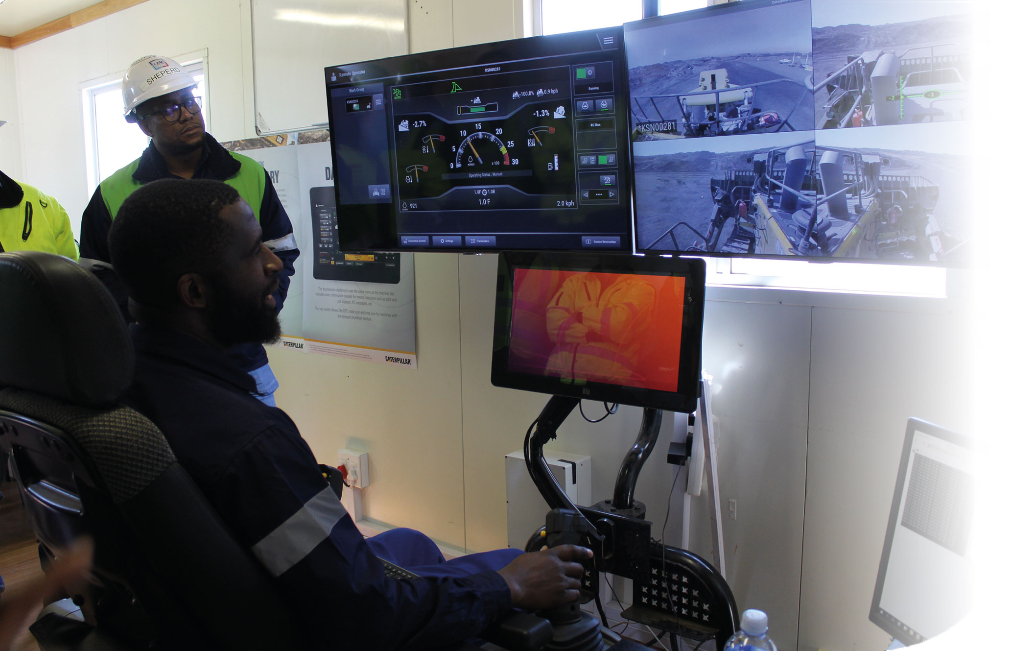
Automated dozing in action at Mafube. From the left: Sheperd Nkadimeng (general manager), Mogodi Mahapa (mining manager) and seated Ernest Sibanyoni (training officer)